

-
 (Photograph by Grant Wylie)
 -
 (Photograph by David Hill)


Myers Park, the premier streetcar suburb of Charlotte, exemplifies the changes of urban living patterns in the early twentieth century. The original Myers Park development comprises 1,200 acres of gently rolling farmland between Providence Road and Sugar Creek, roughly one-and-a-half miles southeast of downtown Charlotte. The land originally belonged to John Springs Myers, whose parents gave him 300 acres in 1869; Myers gradually purchased the rest as he enlarged his cotton farm.
By the 1910s and 1920s, Charlotte had become a booming city and the surrounding Piedmont region was the world’s leading textile-manufacturing hub. Noticing this rapid growth and local prosperity, Myers teamed with his son-in-law, George Stephens, to develop his property as a streetcar suburb conveniently located at the end of the Elizabeth Street line coming south out of downtown. The development was very successful, and many influential people such as J.B. Duke, Cameron Morrison, George Stephens, and members of the Cannon, Springs, and Hanes families, among others, lived in Myers Park. Works of the region’s leading architects, including C.C. Hook, Louis Asbury, and J. M. McMichael, as well as nationally acclaimed designers like Charles Barton Keen from Philadelphia, can be found within the nearly 1,000 houses that make up the neighborhood.
The original neighborhood design, completed in 1911, was by John Nolen, one of America’s most influential early-twentieth-century planners. Nolen studied landscape architecture at Harvard University, and his other works in North Carolina include the Penderlea Homestead outside of Wilmington, the University of North Carolina campus plan, a civic survey and plan for the city of Charlotte, and the Irving Park neighborhood in Greensboro. In 1917, supervision of Myers Park was taken over by Earl Draper, an apprentice in Nolen’s office who had graduated with a degree in landscape architecture from University of Massachusetts in 1915. Myers Park was one of Nolen’s earlier neighborhood plans, and he featured it in his 1927 book, New Towns for Old. The project inspired a generation of similar community plans across the South.
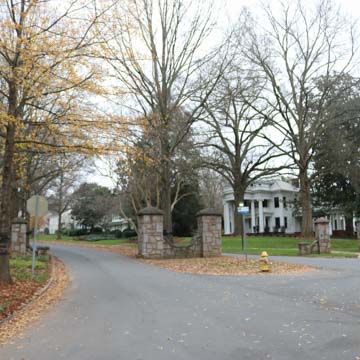
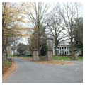
Nolen’s design for Myers Park was intentionally not continuous with the urban grid. Streetcar suburbs were considered a retreat from the increasingly industrialized nineteenth-century city. The original plan included only a few main entrances (guarded by stone gates) that led to a network of winding streets, which deliberately discouraged through traffic. There was a hierarchy of circulation through the neighborhood with the 110-foot-wide Queens Road looping south from the main entrance, functioning as a grand boulevard or “spine” with smaller side streets reaching far corners of the development. The few main entrances and centralized internal circulation allowed Myers Park to function like a large cul-de-sac, independent from the larger urban fabric.
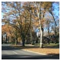
The gently sloping roads, soaring tree canopy, and wide plantings give the impression of a path through a well-manicured forest, despite the fact that this was cleared farmland when Myers and Stephenson began their venture. Nolen provided detailed landscape advice on all aspects of the design. Streets were envisioned as green parkways following the contour of the land with generous sidewalks, planted medians, and shaded by hardwood trees. He provided naturalistic planting plans for public parks integrated throughout the neighborhood and set aside space for an educational facility at the center (now Queens University). Large lots, generous setbacks, and a prohibition of front fences allowed individual gardens to contribute to the overall atmosphere of the larger neighborhood. Supported by Stephens, Nolen even provided individual planting plans for early lots.
Myers Park was developed in three phases. Nolen’s initial design and development lasted from 1911 to 1916, when most streets in the northern half of the neighborhood were built. Houses from this phase were mainly bungalows with single-story or one-and-a-half-story massing. The second phase of development began in 1917 under Draper and lasted until 1926; Draper stayed faithful to most of Nolen’s ideas. In this phase, houses were built in the Colonial Revival style, popularized by the recent restoration and recreation of Colonial Williamsburg, and Tudor Revival also emerged prominently at this time, mixing French and English vernacular architecture and providing opportunity for variety in Myers Park. In mid-1920s, developer George Stephens left the project and the neighborhood entered its third phase of development. Many later streets completed by civil engineers after 1926 lack the attention to detail seen in earlier sections laid out by Nolen and Draper, and a handful of multifamily dwellings catered to middle-income residents.
By 1960 the development of Myers Park was complete, with most subsequent building not on vacant lots but as infill development. Although the landscape is inevitably in a continual state of change, much of the areas laid out by Nolen and Draper remain as initially envisioned.
References
Bishir, Catherine W., and Michael T. Southern. A Guide to the Historic Architecture of Piedmont North Carolina. Chapel Hill: University of North Carolina Press, 2003.
Hanchett, Thomas, “Myers Park Historic District,” Mecklenburg County, North Carolina. National Register of Historic Places Registration Form, 1986. National Park Service, U.S. Department of the Interior, Washington, D.C.