

Plat of Zion
You are here
Salt Lake City
1833 plan, Joseph Smith; 1847 layout; 1859 extension. Downtown Salt Lake City.
-
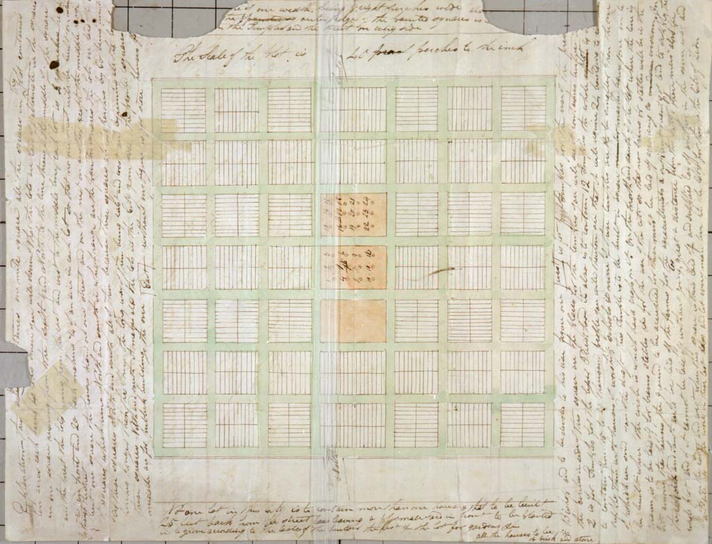
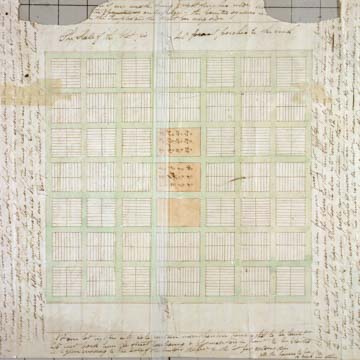 The Plat of Zion with marginal notes, 1833 (Used by permission, Utah State Historical Society)
The plan of Salt Lake City, laid out initially in 1847, is one of the few religiously inspired city plans in North America. It is explicitly based on the “City of Zion,” a plan that had been drawn in 1833 under the direction of Joseph Smith, the founder of the Church of Jesus Christ of Latter-day Saints. Smith’s murder in 1844 precipitated the movement of the Mormons to the American West, an expedition led by Smith’s successor prophet Brigham Young, which eventually resulted in the westward migration of tens of thousands between 1847 and 1890.
Although Smith had located Zion definitively in Missouri by divine revelation, the Latter-day Saints were unable to settle there, and their final destination—Salt Lake City—was a kind of spiritual compromise. The Salt Lake location on the western frontier suited the Mormon’s desire for a “Central Place” to begin their settlement system, which was to be a conquest of nothing less than the entire continent over time. The Mormon belief system called explicitly for a gathering of the faithful into cities to await the second coming. The faithful were called to Zion from around the world, such that believing in the Mormon faith nearly always meant migration to Utah, that is, until 1890, when the church halted the “gathering” as they downplayed the importance of the second coming.
There are several unique aspects of the plan, especially its dimensions. Salt Lake City was laid out in a uniform grid of 660 x 660–foot blocks. Streets, including 20-foot-wide sidewalks, span 132 feet wide. Each block was initially subdivided into 8 equal lots, and each lot was a generous 1.25 acres. There has been much speculation on the intentions of such large lot sizes, but it is clear that self-sufficiency was a motivation: vegetable gardens and fruit trees were expected to be sown and this was largely carried out on these lots in the early years, although unlike an agricultural village, barns and animal holding areas were discouraged in town. In the ideal plan, the lots were to contain a single house set back 20 feet from the street.
In the Plat of Zion, the Temple was to be located at the center of the plan. In Salt Lake City, it appears on the northern edge of the plat, likely due to topographical conditions. All the streets of Salt Lake City, and even its region, are numbered from the southeast corner of Temple Square, making Main Street the clear axis mundi of the Mormon territory. Decades later, when the U.S. Public Land Survey reached Salt Lake City, it acquiesced to this religious regulation by making Main Street the prime meridian of the region and South Temple the base line.
Another remarkable characteristic of the plan is the orientation of the lots. Just as in the original City of Zion plan, the lots were oriented in different directions on every block, creating a basket weave pattern. The intention was privacy for the inhabitants, so that houses would not face each other across the street, but would instead face the sideyards of neighbors—yards that would presumably be planted with gardens.
The Plat of Zion anticipated a quasi-communal economic and spiritual life. It supported polygamy by intertwining families and lessening the influence of the monogamous nuclear family vis-a-vis the church authority. When lots were initially distributed to the first Mormons, the men who had large numbers of wives obtained many more lots, an economic advantage that was to rebound to certain families for many generations. These lots were not usually abutting, suggesting a certain isolation and independence for plural wives and a peripatetic lifestyle for the husband.
After the initial 135 blocks were laid off and distributed, rapid migration resulted in the development of two more large plats in the same pattern and, likewise, these were rapidly allotted to settlers. In addition to the town lots, several lots to the south and east of the town were also laid out, as directed in the Plat of Zion. The “big field” of these outer lots consisted of five-acre parcels grouped in 20 to make one large block. As the city has grown, these fields on the outskirts have been incorporated into the city limits, constituting the blocks between 9th South and 21st South streets in present-day Salt Lake City.
The city grew very rapidly, but most immigrants who arrived were “called” to settle other towns in accordance with the plan to expand Mormonism across the Territory. Brigham Young is said to have founded 360 towns and cities between 1848 and his death in 1877, some as distant as California. The population of Salt Lake City was thus artificially limited, at least until the 1870s, when the church’s grip on the city’s destiny was weakened by the westward creeping of American civilization in the form of the transcontinental railroad, telegraph communication, and rapid settlement by non-Mormons. Abundant mineral resources in the region also brought outsiders.
Despite the extremely formal and theocratic nature of the ideal plan, the first group of Mormon colonizers do not appear to have adhered to the plan with much rigidity, as befits a struggling frontier community. Although the original plan is widely admired, its dimensions were unsuitable for a rapidly growing city. The large lots were immediately subdivided, creating disorderly patterns, but the wide streets and large blocks continue to make the pedestrian experience difficult today.
The awkwardness of the plan as it was developed was apparently a problem of ideology, in that the pioneers realized this plan even though they had experience with town planning in Nauvoo, Illinois, where the initial platted lots were smaller, as were the blocks. Even these smaller lots were frequently subdivided in the few years that Nauvoo grew into a thriving city under the Mormons. In fact, the Plat of Zion calls for much smaller lots: half-acre as opposed to the 1.25 acres of Salt Lake City, although the same generous street dimensions were noted there, as was the large block size. Thus, Young reenvisioned the Plat of Zion as more of an agricultural village rather than the high-density settlement for which Smith had called. The reason for the unusually wide streets is unknown, although it is not likely that it was envisioned around the needs of a team of oxen to turn around, as is popularly believed.
By 1859, a new plat was introduced in northeastern part of the city (a district now called the Avenues). The scale of blocks and streets of the Avenues was half the dimensions of the earlier urban blocks. The reasons for this shift in size were not recorded but surely the abandonment of an agricultural village ideal played a role.
It was necessary from the beginning to adapt the configuration of the lots. The first adaptation was the subdivision of the outside four lots into many smaller lots, defeating the intended opposite orientation for the Mormon plat. This makes great economic sense, as these smaller lots are far closer to standard city lots of the era, even when developed as single-family residences, which nearly all were. The lots subdivided in this manner have greatly varying widths and sizes and the houses built on them (nearly all houses at first) were erected at different times as the lot was divided. Despite clear regulation, uniform setbacks were not observed. The inner four blocks were also subdivided into long, narrow lots that were obviously maladaptive as they left much land unusable for intense development in the inside of the block. In subsequent decades, beginning no later than 1898, this problem was handily solved by creating “mews”—short, dead-end streets with small houses on either side, all fitting into a single original lot. There are countless examples of these mews, almost all of them surviving into the late twentieth century and many still extant.
Late-twentieth- and early-twenty-first-century downtown development has taken advantage of the large blocks and streets, with large footprint towers and interior parking garages being a common pattern. Conversely, the less densely developed “Mormon” blocks are particularly problematic in the present-day city structure. Nineteenth-century houses sit next to modern high-rise hospitals, and expansive schools are next to apartment buildings. The blocks are characterized by multiple land uses, and a disorderly variety of building types, ages, and sizes. The blocks are undifferentiated in size and all the streets are the same thoroughfare-dimensioned width, with no hierarchy. The blocks do not organize into identifiable districts, and this part of the original plat has no edges and no monuments within it, not even a park or a square for orientation.
References
Writing Credits
Coordinator:
Shundana Yusaf
If SAH Archipedia has been useful to you, please consider supporting it.
SAH Archipedia tells the story of the United States through its buildings, landscapes, and cities. This freely available resource empowers the public with authoritative knowledge that deepens their understanding and appreciation of the built environment. But the Society of Architectural Historians, which created SAH Archipedia with University of Virginia Press, needs your support to maintain the high-caliber research, writing, photography, cartography, editing, design, and programming that make SAH Archipedia a trusted online resource available to all who value the history of place, heritage tourism, and learning.