

Moon House
You are here
Moon House Ruin
1225–1290, Ancestral Puebloan. UT 261 approximately 4 miles south of UT 95.
-
 (Photograph by Shundana Yusaf)
 -
 (Photograph by Shundana Yusaf)
 -
 (Photograph by Shundana Yusaf)
 -
 (Photograph by Shundana Yusaf)
 -
 (Photograph by Shundana Yusaf)
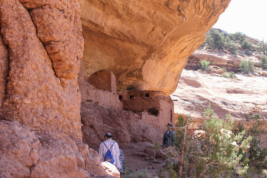
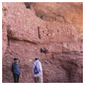
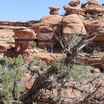
Moon House consists of three late-thirteenth-century Anasazi cliff dwellings built on Cedar Mesa between 1225 and 1290. Located in McLoyd Canyon, just south of the Kane Gulch Ranger Station, it was the largest cliff dwelling complex of its time and provides valuable information about Anasazi strategies for ensuring food security.
The building complex sprawls over half a kilometer, and consists predominantly of storage rooms and granaries. Following a mass influx of people to the area following the decline of Chacoan culture in 1150, the stress of migration was exacerbated by an increase of poor harvests. Between the years 200 and 1300, Anasazi abandoned the Cedar Mesa uplands when soil buffering systems could not sustain crops, and they returned only when agricultural production and water supplies were able to support the population. It seems that the Moon House site was built and rebuilt over several centuries and during the last occupation around 1264, it was used as one integrated complex. The area was first partially recorded in 1964 with extended documentation occurring in 1989.
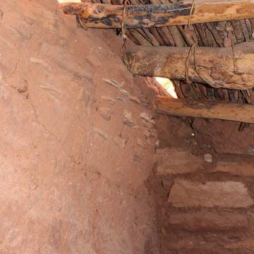
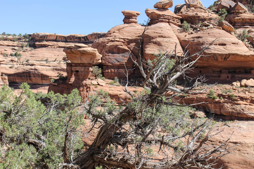
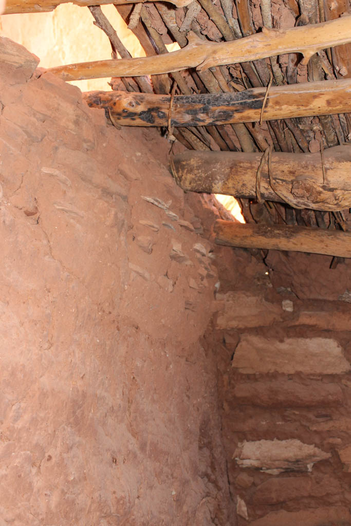
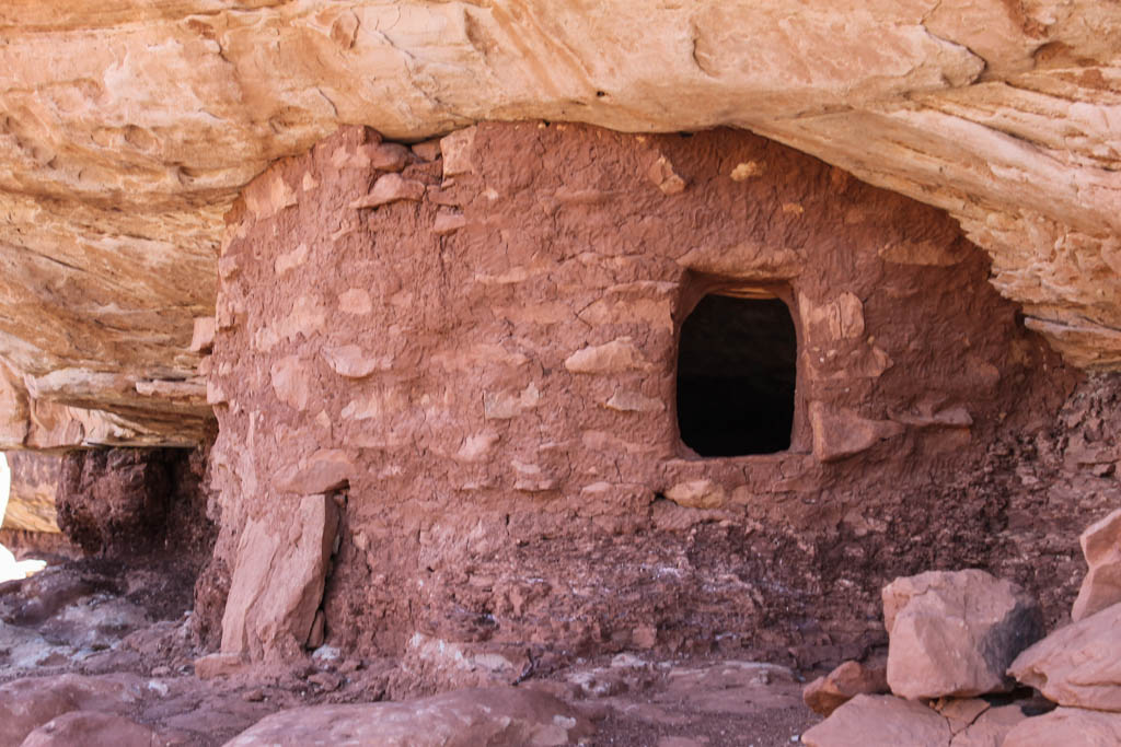
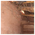
The upper reaches of McLoyd’s Canyon are relatively shallow, dropping down to an approximate depth of 160 feet at its eastern extent. The canyon walls range from short, vertical drops to sloping talus deposits. Horizontal ledges terrace the canyon sides, but they are small and not often sheltered. There are few cliff dwellings in the upper reaches of the canyon, and these contain the ruins of small masonry habitations and storage rooms. Archaeological finds at Moon House include ceramic shards (white, red, and gray ware), projectile points, different chipped stone tools, chipped stone debitage, cores, manos, bones, and other organic materials (including botanical materials and cordage). Beams and sticks were exclusively juniper, pinyon, and conifer. Springs and seeps provided water, probably throughout the summer, and there is pedestrian access in and out of the canyon.
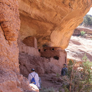
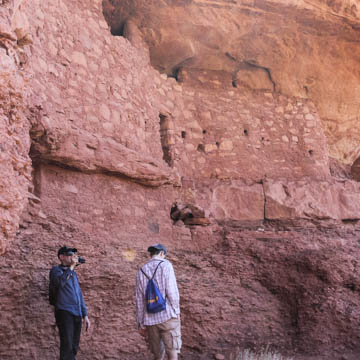
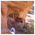
Ancestral Puebloan granaries, cliff dwellings, campsites, great houses, roads, petroglyphs, and natural observatories reveal these people to be astute students of landscape. It is therefore little surprise that they spread the three dwellings in well-suited crevices of McLoyd's Canyon. A walkable ledge, high above the canyon floor, connected the structures to one another. Broadening in places and adventurously narrowing in others, the ledge also went up and down unevenly. There are forty-nine rooms in total at the site, thirty-two of which are well preserved.
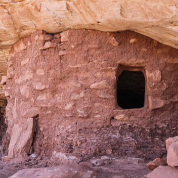
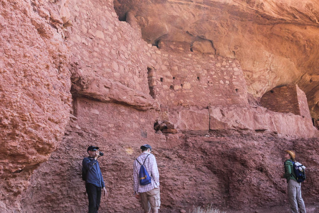
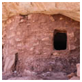
Although the three structures are called “dwellings,” only the middle structure has habitable rooms—five in total. The rest of the structure contains nine granaries, a general storage room, two rooms of unknown function, and one kiva, which is in a ruinous state. The dwelling to the east is a block of six granaries. Ruins of possibly two earlier habitation rooms and two or three earlier storage rooms are also evident within the same shelter. The distance between this storage house and the central dwelling is spanned by three other well-preserved individual granaries and the ruins of at least seven earlier storage structures. The cliff dwelling on the west side, in turn, is composed of an aboveground kiva with three storage rooms, one large room of undetermined function, and the ruins of another contemporaneous room of unknown function. The size of the storage rooms seems to have been governed by the ease of access and the need to separate goods and food items in different spaces. Kivas suggest ceremonial rituals possibly associated with storage.
The fact that only five out of forty-nine known rooms were meant for habitation tells us something important about this period. Moon House had the potential to store approximately twice as much corn as any other cliff dwelling in the area and could feed a population of 147 people for a whole year. Thus, it marks a departure from traditional land use patterns. Archaeologist William D. Lipe, who has studied Moon House and settlement patterns in Cedar Mesa, hypothesizes that Moon House could have been a food and agricultural distributional center serving a population larger than the one that could have lived in the complex. The greater population would have been drawn from eastern Cedar Mesa or Comb Wash. The Moon House suggests cooperation among many households functioning as a communal socio-economic unit.
The architecture of Moon House also suggests that food security not only required the provision of space but also of defense. Developments on high ledges with limited access are characteristic of the Anasazi. In addition, the main dwelling in the center places its block of habitable rooms behind a defensive wall with restricted access and loopholes (small openings that allow observation but not passage). The rooms were entered through an enclosed corridor—an anomaly in Anasazi pueblos. Loopholes are common not only in Cedar Mesa but also throughout the northern Colorado Plateau. Yet, instead of surveying probable attack routes, for an unknown reason some of the observation ports in Moon House look down directly on the main shelf on which the structure stands.
Moon House was the largest but not the only storage site in the area. These other storage areas were strategically dispersed throughout the canyons to take advantage of the marginal Cedar Mesa resources and to maximize agricultural potential. Fields were probably planted in a variety of physiographic locations to minimize against catastrophic crop loss. The dispersed fields were tended and protected by people living at the small, dispersed habitation sites, or episodically at the field “stations.” There is a prevalence of both isolated storage structures and those associated with habitation sites. After a thousand years of cyclic occupation and abandonment, storage systems were developed by the Anasazi to provide food during short-term dry periods. Dry conditions in the mid-thirteenth century seems to have put increasing demands on food storage before leading to the final abandonment of Cedar Mesa by the Anasazi in the late thirteenth century.
The Bureau of Land Management currently manages the site.
References
Bloomer, William W. “Moon House: A Pueblo III Period Cliff Dwelling Complex in Southeastern Utah.” Master’s thesis, Washington State University, 1986.
Eggan, Fred. Social Organization of the Western Pueblos. Chicago: University of Chicago Press, 1950.
Euler, Robert, and George J. Gumerman, eds. “Settlement Patterns on Cedar Mesa: Boom or Bust on the Northern Periphery.” In Investigations of the Southwestern Anthropological Research Group: The Proceedings of the 1976 Conference, 1-12. Flagstaff: Museum of Northern Arizona, 1978.
Lindsay, La Mar W. “Big Westwater Ruin.” In Excavation of Two Anasazi Sites in Southern Utah, edited by Richard E. Fike and David B. Madsen, 1-237. Moab, UT: Bureau of Land Management, 1981.
Lipe, William D. “Centralized Storage at Moon House, A Pueblo III Cliff Dwelling in SE. Utah.” Paper presented at the 43rd Annual Meeting of the Society for American Archaeology, Tucson, 1978.
Lipe, William D., and R.G. Matson. “Human Settlement and Resources in the Cedar Mesa Area, Southwestern Utah.” In The Distribution of Prehistoric Population Aggregates, edited by George Gumerman, 126-151. Prescott, AZ: Prescott College Anthropological Reports, 1971.
Writing Credits
Coordinator:
Shundana Yusaf
If SAH Archipedia has been useful to you, please consider supporting it.
SAH Archipedia tells the story of the United States through its buildings, landscapes, and cities. This freely available resource empowers the public with authoritative knowledge that deepens their understanding and appreciation of the built environment. But the Society of Architectural Historians, which created SAH Archipedia with University of Virginia Press, needs your support to maintain the high-caliber research, writing, photography, cartography, editing, design, and programming that make SAH Archipedia a trusted online resource available to all who value the history of place, heritage tourism, and learning.