

-
 (Virginia Department of Historic Resources)

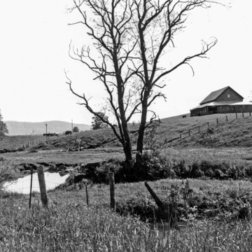
This National and Virginia Rural Historic District is a natural oval-shaped basin, ten miles in diameter, bounded by the high walls of Garden Mountain. At approximately three thousand feet above sea level, it is the highest mountain valley in Virginia. In its isolated position, the scenic bowl has maintained a rural nineteenth-century character with few modern intrusions. The lush limestone soil of the Garden produces bright-green pastures ideal for raising cattle. Here and there, limestone sinkholes, some forming ponds, crater the landscape. Farm buildings cluster around houses that are generally two-story three-bay frame structures, often with a central front gable and interior corbeled chimneys and usually with a one-story front porch. An occasional brick or stone structure embellishes the landscape and even a few Queen Anne houses break with the local traditions of plain construction.
Although the area was surveyed in the 1740s by James Burke and his team, it was not settled until c. 1800. A number of its early settlers were Germans, making it one of the farthest outreaches of German settlement in Southwest Virginia. As early as the 1820s, German Lutherans were worshiping at a Union church on the site of the present Burke's Garden Central Church and Cemetery (1875; Center Road). This small, rectangular frame church has a gable-end central entrance flanked by two small windows, much like its mother church, St. John's Lutheran Church (WY18) in Wytheville. It also has some remarkable gravestones ornamented with such traditional German motifs as sunflowers, vines, stars, pinwheels, and hearts. These stones are thicker than the graveyard's other markers, are sometimes reeded on the edges, and often have inscriptions on both sides. Except for a store or two, Burke's Garden is a scenic agricultural haven where two or three automobiles constitute a traffic jam.