

Freeway Park; Seattle Freeway Park
You are here
Jim Ellis Freeway Park
1970–1976, Lawrence Halprin and Associates; 1984 Piggott Memorial Corridor, NBBJ, architects; Danadjieva and Koenig Associates, architects and urban designers; 2005 planting renovation, Ian Robertson and Ted Holden, landscape architects; 2007 James R. and Mary Lou Ellis Plaza, Danadjieva and Koenig Associates. Above I-5 between Pike and Spring sts.
-
 Aerial view at night (Photograph by Dllu, CC BY-SA 4.0)
 -
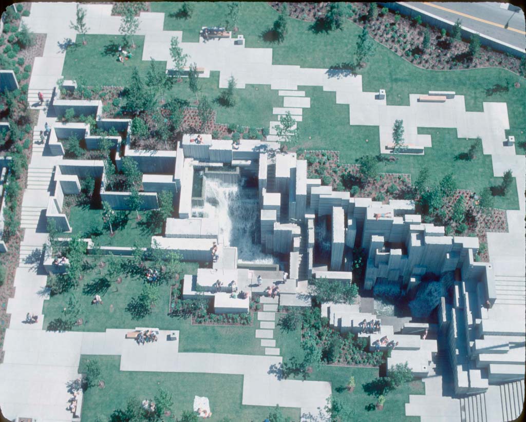
 Aerial view, 1970s (Courtesy Seattle Municipal Archives, CC BY 2.0)
 -
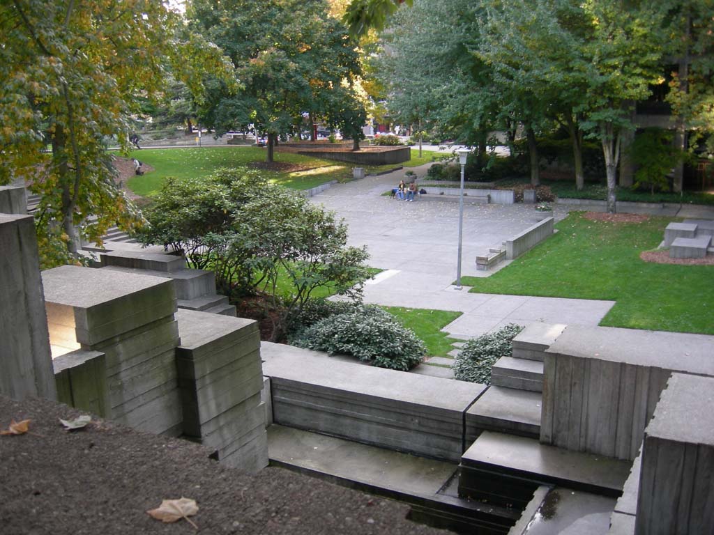
 (Photograph by Joe Mabel, CC BY SA-3.0)
 -
 (Photograph by Brianc333a, CC BY-SA 4.0)


Seattle’s Freeway Park was the first park in the United States to be built atop a highway to reconnect the neighborhoods the highway had torn asunder. In 1966, I-5 was cut through the edge of Seattle; running north-south, it divided downtown from neighborhoods to the east. When Freeway Park opened in 1976, it became a model for other cities seeking to heal the divisions that postwar highway construction had caused. Designed by Lawrence Halprin and Associates, the park also became an icon of modern landscape architecture, with stylized concrete canyons that are the tallest and most extensive the firm ever executed.
Freeway Park was not the first public landscape built on top of a highway; that distinction belongs to Carl Schurz Park in New York City, which opened in 1940 over the East River Drive and was followed by the Brooklyn Heights Promenade, which opened in 1950 over the Brooklyn Queens Expressway. Freeway Park is distinctive in that it was neither planned nor constructed at the same time as the highway running beneath it. In addition, Freeway Park celebrates, rather than ignores, its position atop a highway, which is something the previous projects do not.
The idea of covering a portion of I-5 with a public park was first proposed in 1961 by the architect Paul Thiry. Highway planners rejected this proposal outright, and the 12-lane interstate was designed and built with no consideration of a future retrofit with a lid-cum-park. The idea was revived in the years after the 1966 publication of Lawrence Halprin’s book Freeways, which argued that freeways had the potential to be “a new form of urban sculpture for motion,” but only if they were planned with an understanding of their sociological and physical impacts. Throughout his book, Halprin offered numerous strategies for integrating freeways with the urban fabric through parks, buildings, and open spaces.
Prior to the construction of Freeway Park, a small plaza occupied a portion of the site. Constructed in 1967, this modestly scaled plaza included a fountain with a sculpture by George Tsutakawa. Dwarfed by the freeway beside it, the plaza represented a missed opportunity to local officials and architects. Those who had read Halprin’s book argued that more dramatic action was necessary along the interstate to better integrate it into the city. The civic-minded attorney James Ellis, who was the driving force behind a bond program for new parks, rallied political support for a park bridging the freeway. Halprin’s own work with the U.S. Department of Transportation (he had co-authored an important report for the department in 1968) helped pave the way for federal funds that covered much of the park’s construction costs.
Lawrence Halprin and Associates was hired to lead the Freeway Park project in 1970, shortly after the firm’s Auditorium Forecourt Fountain opened in Portland. Angela Danadjieva, project designer for the fountain, served in the same capacity for Freeway Park. As she developed both of these projects, Danadjieva sculpted clay models to test scale and shadow and her collaborator Byron McCulley credits her with introducing this approach to Halprin’s firm, which more typically used layered cardboard models like the one Halprin and architect Charles Moore had used when designing Lovejoy Plaza. This wasn’t just about representation; it was also associated with a different aesthetic.
Freeway Park’s design was a direct response to the highway below with distinct aspects seeking to reveal its presence, mitigate its effects, and confront the challenges prompted by erecting a landscape on transportation infrastructure. Dramatic overlooks over the freeway and a translucent panel behind one of the park’s waterfalls encouraged visitors’ awareness of the freeway. For the most part, however, the designers blocked out highway noise and pollution, using plantings, walls, and the sound of water flowing down blocky concrete cascades, which were intended not only to be viewed but also to be entered. They provided places for people to play and cool off. Plants such as cotoneaster and English ivy, rooted in lightweight soil mixes, grow in drapes across the board-formed concrete walls found throughout the park. Similar concrete boxes, also draped with greenery, announce the park from the freeway below and were scaled to be perceptible to motorists passing by at high speeds. In contrast, the landscape elements within the park were scaled to the perception of slower-moving park visitors.
The park opened on Independence Day in the Bicentennial Year of 1976, and has since seen a number of additions. Since 1984, a series of ramps known as the Piggott Memorial Corridor have provided universal access to the park from nearby senior housing. Four years later, a convention center that borrowed from the park’s aesthetics rose over the freeway. Danadjieva and Koenig Associates, founded after Halprin’s firm was sold, played a leading role in these additions.
In recent years, the park has been at the center of local and national debates focused on crime, homelessness, and public urban space. Seattle-based writer Paul Roberts has argued that the parks’ many nooks and alcoves were difficult to surveil, making them ideal as sleeping niches for the homeless or as sites for a range of illicit activities. Though a few high-profile incidents involving criminals and homeless people kept Freeway Park’s safety issues in the news over the next two decades, reporters who actually looked at the figures found that the crime rate in Freeway Park was among the lowest in Seattle.
In the mid-2000s, the Project for Public Spaces presented a controversial and so-far-unrealized proposal to remove part of the park’s cascades and open up sight lines. More modest executed changes include widening a narrow tunnel under the Eighth Avenue overpass where robberies had occurred. The city replaced the park’s 100-foot-tall light standards with lights on shorter posts, which users considered less “spooky” than the originals; and it placed wood boards across benches to keep people from reclining on them. Landscape architects Iain Robertson and Ted Holden redesigned the park’s plantings beginning in 2005, thinning out many areas. Bright red movable furniture was also added around this time, and more events were organized to enliven the park.
Today, the park attracts a diverse mix of users, including office workers and retired people, along with residents of high-end condos and transients. It is also frequented by practitioners of parkour who make athletic use of walls, benches, and boxes.
References
“Cold Wind Scorned by Mayor on Tour; Carl Schurz Park, improved and enlarged, is reopened.” New York Times, December 11, 1940.
Danadjieva, Angela. “Danadjieva on the Creative Process.” Landscape Architecture, September 1977.
Dandadjieva and Koenig Associates. “The Select Portfolio of Danadjieva and Koenig Associates.” Accessed June 30, 2015. http://dkassociates.com.
Halprin, Lawrence. Freeways. New York: Reinhold Publishing Corporation, 1966.
Harnik, Peter and Ben Welle. “Nature Over Traffic: If you thought Seattle’s Freeway Park was the only example of a park built over a freeway, think again.” Landscape Architecture, February 2008.
Hines, Susan. “Contested Terrain: This month’s LA Forum visits to ailing Seattle parks to ponder the question: To what extent should these icons be preserved.” Landscape Architecture, May 2005.
Hinshaw, Mark. “Two Urban Parks: Portland and Seattle offer lessons in building parks that respond to freeways.” Landscape Architecture, October 1999.
Hirsch, Alison. “Three: Seattle Freeway Park, Seattle, Washington.” Studies in the History of Gardens and Designed Landscapes: An International Quarterly26, no. 1 (2006): 57-87.
Marshall, Margaret. “How the Impossible Came to Be.” Landscape Architecture, September 1977.
McCulley, E. Byron. Interview by Daniel Jost, August 2012.
Mudede, Charles. “Topography of Terror: Seattle's Freeway Park is a garden of earthly delights—for the city's crazed murderers and inhuman rapists!” The Stranger, August 22, 2002. Ac
Mudede, Charles. “A Woman, A Sculpture, A Park: Angela Danadjieva knows more about I-5 than anyone else.” The Stranger, May 17, 2007.
Rapuano, Michael, Lawrence Halprin, L. Kavanagh, H. R. Powell, K. Roche, M. L. Rockwell, J. O. Simonds, and M. R. Springer. The Freeway in the City. Washington, DC: US Government Print Office, 1968.
Roberts, Paul. “Freeway Park: Still an Icon, But a Few Glitches at 25.” Landscape Architecture, February 1993.
Robertson, Iain M. "Replanting Freeway Park: Preserving a Masterpiece." Landscape Journal31, no. 1 (2012): 77-99.
“Seattle’s ‘Urban Sculpture for Motion.’” American Institute of Architects Journal56, no. 3 (September 1971): 53-54.
Woodbridge, Sally. “Green Lid for I-5.” Progressive Architecture, June 1977.
Writing Credits
Coordinator:
Thaïsa Way
If SAH Archipedia has been useful to you, please consider supporting it.
SAH Archipedia tells the story of the United States through its buildings, landscapes, and cities. This freely available resource empowers the public with authoritative knowledge that deepens their understanding and appreciation of the built environment. But the Society of Architectural Historians, which created SAH Archipedia with University of Virginia Press, needs your support to maintain the high-caliber research, writing, photography, cartography, editing, design, and programming that make SAH Archipedia a trusted online resource available to all who value the history of place, heritage tourism, and learning.