

-
 (Photograph by Robert R. Franklin)
 -
 (Photograph by Robert R. Franklin)
 -
 (Photograph by J. Philip Gruen)
 -
 (Photograph by J. Philip Gruen)
 -
 (Photograph by J. Philip Gruen)
 -
 (Photograph by J. Philip Gruen)
 -
 (Photograph by J. Philip Gruen)
 -
 View towards Columbia Bar (Photograph by J. Philip Gruen)


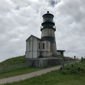
Cape Disappointment Light beams above the entrance of Cape Disappointment and the mouth of the Columbia River, the major transportation and economic waterway in the Pacific Northwest and the fourth largest river, by volume, in the United States. The light also warns mariners of the Columbia Bar—the “Graveyard of Ships”—a shifting sandbar at the mouth of the Columbia River that is one of the most difficult to navigate in the world. Built in 1854 by an Act of Congress that authorized the construction of the first eight lighthouses on the West Coast (the others were in California), it is the oldest operating lighthouse in the Pacific Northwest.
Indigenous peoples have inhabited the area around the mouth of the Columbia River drainage for over 15,000 years and have many names for it, but none are known specifically for the region around Cape Disappointment. The cape was one of the first geographic points in Washington to bear a European name, the “San Rogue” (or Cape Rogue), given by Spanish explorer Bruno Heceta for both the cape and the river in 1775. In 1788, the fur trader John Mears unsuccessfully attempted to take respite from the high seas in Cape Rogue, noting in his journal “Disappointment continued to accompany us…we can safely exert that no river San Rogue exists.” Mears renamed Cape Rogue as “Cape Disappointment” to match his feelings at the time, and despite a later attempt to rename the lighthouse as Cape Hancock, the name of “disappointment” stuck.
Travel to and through the cape increased in the nineteenth century as English and American political and economic ambitions grew in the Pacific Northwest. In 1805–1806, the Lewis and Clark Expedition overwintered in modern day Astoria, Oregon, across the cape from the modern-day lighthouse. Britain claimed the cape and Fort Astoria during the War of 1812, but the Treaty of Ghent gave the territory back to the Americans. Control over the area remained in flux because neither England nor America had enough of a presence in the Pacific Northwest to securely claim the area. Both nations claimed the territory through ceremonies in 1818, whereby a ship from each nation entered the Columbia River and landed a party ashore, which then hiked the bluff, nailed a claimant tablet to a tree, turned a shovelful of earth, and saluted the flag of its respective nation. The 1846 Oregon Treaty ceded all lands below the forty-ninth parallel to America and effectively settled the matter.
Shortly after the negotiation of the Oregon Treaty, Lieutenant Hartman Bache of the Army Topographical Engineers surveyed the entire west coast and selected eight lighthouse sites, seven in California and one in the newly named “Washington Territory.” On March 3, 1851, a $53,000 contract was awarded to Gibbons and Kelly of Baltimore, Maryland, for the design and construction of all the lighthouses. In early 1853, after depositing construction materials for the seven California lighthouses, the ship Oriole set out for Cape Disappointment but ran aground on the mouth of the Columbia and was washed out to sea. The crew was spared, but the materials were lost with the ship.
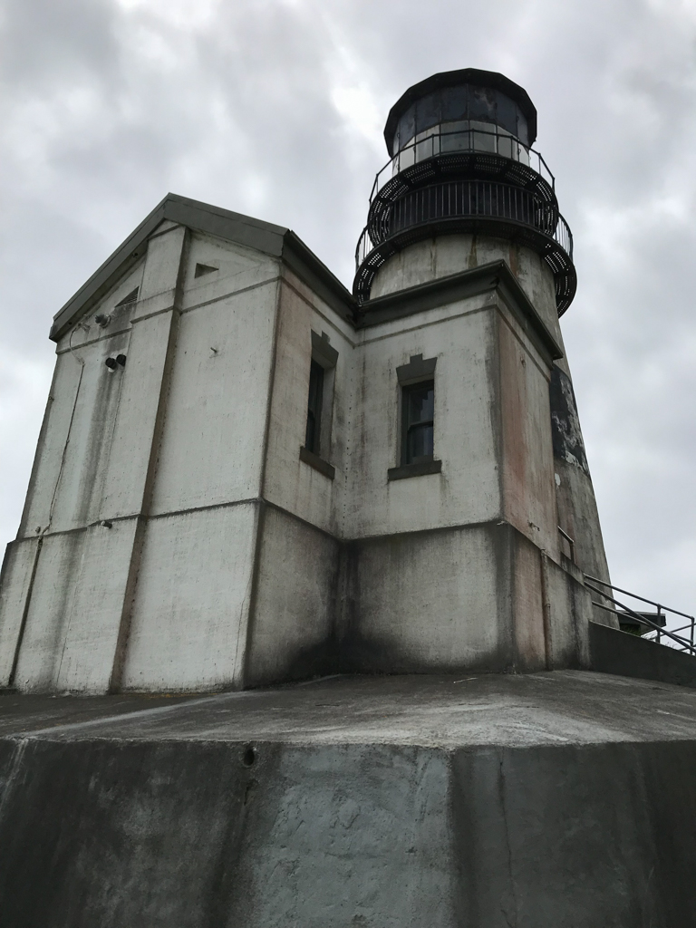
A second shipment of supplies arrived in 1854 and the construction of the lighthouse began, albeit with one major change. A new lighthouse board decided in the same year to replace the refractor system called for in the original designs with a French Fresnel lens. To accommodate the enormous 8-foot-tall, 6-foot-diameter, and 6-ton lens, however, original plans for the lighthouse, which had included rooms and living spaces for the light keeper, required alteration. As a result, the light keeper’s house was constructed as a separate building.
The Cape Disappointment Light is 53 feet tall with a focal plane of 220 feet above the sea, and tapers from 14 feet and 4 inches at the base to 10 feet and 6 inches at the lantern room. The tower and adjacent oil room rest on a concrete base and are constructed of brick with a stucco exterior. The brick for the tower is 5 feet thick at the base and 2.5 feet thick below the lantern room. A 1,600-pound fog bell, originally adjacent to the oil house, was later removed because it was inaudible at a distance over the roar of the surf.
Construction was complete in 1854, but operations did not commence until the Fresnel lens was installed on October 1, 1856. What was called the “most sorely needed light tower in the continental United States” became operational and threw its light 24 miles out to sea, using 170 gallons of oil a day to do so. Surrounding structures for the lighthouse were developed first during the Civil War with the addition of fortifications. A lifesaving station was established in 1871 due to the efforts of the second head keeper, Captain J.W. “Joel” Manson, who refurbished a lifeboat found on the beach and succeeded in petitioning for construction of a boathouse.
Life for the early keepers was tough at this isolated site, which lacked a regular connection to Astoria until ferry service was established in 1926 approximately 12 miles away. The first head keeper, John Boyd, kept watch in the tower without a stove during the unpleasant fall and winter weather. Surviving letters to his superiors in San Francisco detail the hardships, including pervasive flooding in the keepers’ quarters (located a quarter-mile from the tower), the lack of basic supplies, and only intermittent payment. A new double dwelling for keepers was built in 1871 and alleviated many of the problems with the original residence, but nothing could be done about the remote location.
Shortly after completion of the light, mariners lodged complaints with the Lighthouse Board in San Francisco about difficulty spotting the Cape Disappointment Light from the north. In 1893, the board funded the construction of North Head Light, two miles to the north, and moved the first-order Fresnel lens to the new lighthouse, demoting the Cape Disappointment Light to a fourth-order Fresnel lens. The original first-order lens was later removed from North Head Light and currently resides in the Lewis and Clark Interpretive Center at Cape Disappointment State Park. The distinctive black band around the tower was added in 1930 to distinguish Cape Disappointment Light from North Head Light. A Class C radio beacon was added in 1936 and the light was electrified in 1937.
The U.S. Coast Guard planned to discontinue the light in 1965, but protests led by the Columbia River Bar Pilots kept the light in service, and it was automated in 1973. The Cape Disappointment Historic District, including the Cape Disappointment Light as well as the surrounding fortifications and the North Head Light, was added to the National Register of Historic Places in 1975. Today, the area is a state park and is open year round.
References
“Cape Disappointment, WA.” Lighthouse Friends. Accessed May 22, 2017. www.lighthousefriends.com.
Hanable, William S. “Lighthouses on Cape Disappointment.” Essay 5622. HistoryLink.org: The Free Online Encyclopedia of Washington State History, December 6, 2003. Accessed June 30, 2017. www.historylink.org.
Hansen, David M., “Cape Disappointment Historic District,” Pacific County, Washington. National Register of Historic Places Inventory-Nomination Form, 1972. National Park Service. U.S. Department of the Interior, Washington, D.C.
Wheeler, Wayne. “Cape Disappointment Light Station.” The Keeper’s Log. Spring 2005.