

Old Scituate Light
You are here
Scituate Light
1811, Charles Gill, Nathel Gill, Jr., and Joseph Hammond, Jr.; 1827 expansion. 100 Lighthouse Rd.
-
 (Photograph by C. Ian Stevenson)
 -
 (Photograph by C. Ian Stevenson)
 -
 (Photograph by C. Ian Stevenson)
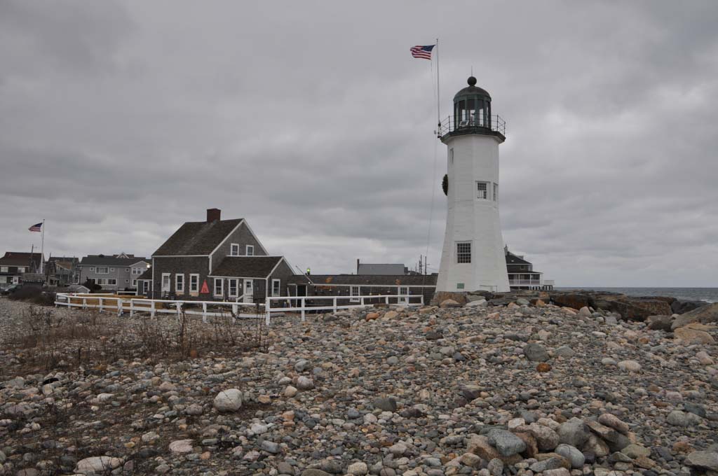
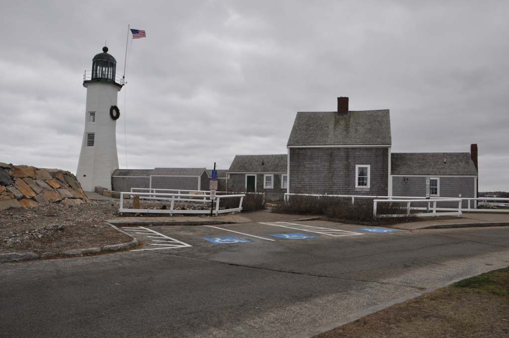

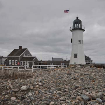
Lighthouses are among the most iconic structures of Massachusetts. Old Scituate Light, built in 1811, is one of the oldest in the state, the eleventh oldest in the nation, and guards the best harbor of refuge (due to the reach of natural land barriers around a large water basin) along the state’s eastern shore from Marblehead to the Cape Cod Canal. Despite a relatively short period of active use in the first half of the nineteenth century, the Scituate Light represents a building typology of enormous economic and social importance that today supports a robust tourist economy. Scituate Light is also significant for its role in the War of 1812 and the “The American Army of Two” incident that occurred when two daughters of the keeper purportedly scared away an invading British landing party by playing a fife and drum to trick them into thinking that a militia was approaching.
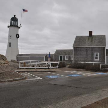
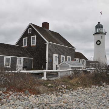
Scituate Light sits at the end of Cedar Point, a small, narrow peninsula that forms one side of Scituate Harbor and is part of the approach to Boston Harbor. Its immediate surroundings are cleared land that facilitates the lighthouse’s visibility from sea. Its only proximate neighbor is an adjacent keeper’s house, built in 1811, that connects to Scituate Light through the kitchen ell by an enclosed walkway, which allowed for service of the light during all weather conditions; a later ell was added to the opposite side of the keeper’s house in 1847.
During the eighteenth century, Scituate was a major fishing port, but entering its harbor was treacherous due to mud flats and shallow water, which led the town to petition the federal government in 1810 for funds to build a lighthouse at the harbor entrance. In 1811, the United States Government purchased by eminent domain the land at the end of the peninsula and appropriated funds for the lighthouse. Constructed by local builders Charles Gill, Nathel Gill Jr., and Joseph Hammond Jr., and activated that year, the initial Scituate Light was a 25-foot-tall masonry tower of split granite blocks in an unusual splayed octagonal form. In 1827, the federal government added fifteen feet, in brick, to the tower and replaced the lantern to increase its visibility from the open sea. This renovation led to the display of a fixed white light from the lantern and a red light from the lower windows, all amplified by reflectors. The white-over-red configuration aimed to distinguish Scituate Light from Boston Light a few miles up the coast. It proved insufficient at greater distances, and in 1841, a new lighting apparatus and a lantern were installed. Six years later, the never-optimal Scituate Light, then showing only a fixed red light, shared duty in the harbor with Minot’s Light, situated a mile offshore on a rock outcrop. Scituate Light regained importance in 1851 when a storm destroyed Minot’s Light, but a replacement of that lighthouse in 1860 completely obviated the need for Scituate Light and led to its deactivation that year. In the succeeding decades it fell into disrepair.
In 1907, members of the Daughters of the American Revolution petitioned for Scituate Light’s restoration, but in 1912 the federal government planned to auction the property. A financial pledge by the Town of Scituate halted the proceedings, and in 1917 the Town purchased Scituate Light with a deed specifying its maintenance of the property as a historic site. In 1930, the Town installed a replica light (the original long since removed), but by the 1960s it had fallen again into disrepair and was subjected to vandalism. In 1968, the Town made an agreement with the Scituate Historical Society for its upkeep. In the 1990s, the Scituate Historical Society installed newly functional lights for private navigational aid and in 2001 converted the walkway between the building and the keeper’s house into an exhibition space. Subsequent minor renovations have made the buildings more livable and safer and better suited to being occasionally open to the public for interpretation. The Town of Scituate still owns both the lighthouse and the keeper’s house, continuing to lease them to the Scituate Historical Society, which rents them for income. Thus, a structure once showcasing the federal government’s authority, has become to an object of pride for the local municipality and operated through a public-private collaboration. Today the lighthouse and keeper’s house remain centerpieces of the town’s history.
References
“History of Scituate Light, Massachusetts.” New England Lighthouses. Accessed May 14, 2019. http://www.newenglandlighthouses.net/.
Melhuish, Geoffrey E. “Form A – Area: Cedar Point, Scituate, MA (SCI.V).” Boston: Massachusetts Historical Commission, September 2002.
Miller, Allen S. “‘The Lighthouse Top I See’: Lighthouses as Instruments and Manifestations of State Building in the Early Republic,” Buildings & Landscapes: Journal of the Vernacular Architecture Forum17, no. 1 (Spring 2010): 13-34.
Salzman, N. “Form A – Area: Scituate Light, Scituate, MA (SCI.K).” Boston: Massachusetts Historical Commission, July 1981.
“Scituate Lighthouse.” Scituate Historical Society. Accessed May 14, 2019. http://scituatehistoricalsociety.org/.
Vollmer, Carol. “Form B – Building: 100 Lighthouse Road, ‘Scituate Lighthouse,’ Scituate, MA (SCI.908).” Boston: Massachusetts Historical Commission, 1972.
Zimmerman, Sarah J. et al., “Lighthouses of Massachusetts (Thematic Group Nomination),” Barnstable, Bristol, Dukes, Essex, Nantucket, Norfolk, Plymouth, and Suffolk Counties, Massachusetts. National Register of Historic Places Inventory-Nomination Form, 1986. National Park Service, U.S. Department of the Interior, Washington, D.C.
Writing Credits
Coordinator:
Daniel Bluestone
If SAH Archipedia has been useful to you, please consider supporting it.
SAH Archipedia tells the story of the United States through its buildings, landscapes, and cities. This freely available resource empowers the public with authoritative knowledge that deepens their understanding and appreciation of the built environment. But the Society of Architectural Historians, which created SAH Archipedia with University of Virginia Press, needs your support to maintain the high-caliber research, writing, photography, cartography, editing, design, and programming that make SAH Archipedia a trusted online resource available to all who value the history of place, heritage tourism, and learning.