


The federal government’s Depression-era socioeconomic initiatives of the 1930s impacted Alabama in numerous ways, from the great dams of the Tennessee Valley Authority to the preparation of the first statewide guidebook under the auspices of the Federal Writers Project. Architecturally, tangible evidence still exists in dozens of civic and recreational structures scattered about the state: post offices, courthouses, a few surviving public housing projects, swimming pools, picnic pavilions, and park and recreational facilities. This was the decade that really marked the beginning of the Alabama state park system as it is popularly perceived today: with rustic log cabins, picnic shelters, man-made lakes for swimming and fishing, and leafy hiking trails.
Cheaha State Park, established in 1933 astride the Appalachian ridges that spill into northeastern Alabama from Georgia and Tennessee, preserves the state’s best concentration of recreational architecture that grew out of the Works Projects Administration (WPA). Here, on and around the 2,411-foot Mount Cheaha (the highest point in the state), are some twenty structures from the period, scattered amid nearly 3,000 acres of rugged wooded terrain. In the early twentieth century this was one of the most remote, albeit scenic, regions of the state, a place of dense forests and stony crags, rippling brooks, and scattered, isolated mountain homesteads. Its inhabitants were also poor for the most part, and likely beneficiaries of a broadly conceived improvement program.
Work at the site began in 1934, with construction of a hand-dug, 250,000-gallon reservoir to supply water for the park buildings through a gravity-fed distribution system. With labor furnished by scores of young men who were enrolled in the newly created Civilian Conservation Corps, the park and its initial infrastructure were developed over a nine-year period that ended only in 1942, following the outbreak of World War II. Part of the infrastructure included cutting public access roads to the park from the nearby towns of Munford and Talladega. The early years of construction saw the development of a primitive campground; the completion of an earthen dam that created a six-acre recreational lake for boating, fishing and swimming; and the erection of a bathhouse, picnic pavilions, overnight cabins, an observation tower, a pair of four-room caretakers cottages (one with a two-car garage), and two stone bridges arching over Hillabee and Dry Creeks at the foot of Mount Cheaha.
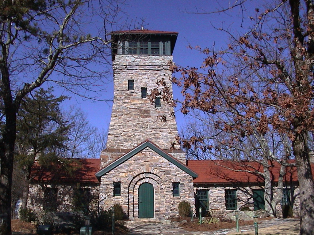
Bunker Tower, the observation tower named for state forester Colonel Page S. Bunker, doubled as a fire observation post and public lookout. Built of native stone, with base walls over a yard thick, the tower rose seventy-five feet from the crest of Mount Cheaha. Entering an embrasured doorway at the tower’s base, visitors climbed a twisting flight of steps to reach an observatory that offered a sweeping panorama of surrounding mountains. Low, gabled pavilions flanking the tower housed park administrative offices. Though the building’s architect remains a mystery, its sophisticated design suggests a professional hand—either one of the private firms occasionally contracted for WPA work or the national office itself.
Like Bunker Tower, all original Cheaha structures were constructed of local stone, with CCC laborers receiving on-the-job training as they laid the masonry walls. Ten rustic, tile-roofed cabins, completed in 1935–1936, each had a combination living room/kitchen with fireplace, as well as a bedroom and bath. There was also a “Dutch oven,” a pantry with sink, and a septic tank to serve each cabin. At first, lighting was only by kerosene lamps. Two picnic pavilions and a lakeside bath house, completed in 1937, were followed by Bald Rock Lodge, a combination restaurant and hotel. Vigorously advocated by area chambers of commerce, the lodge was finished after the beginning of World War II and was the last and largest building in the original complex.
Echoing the spirit of much New Deal recreational and park architecture from coast to coast, Cheaha’s structures were calculated to “echo the pioneer theme in their outward appearance, whether constructed of logs, shakes, or native stone.” In the words of architectural consultant Albert Houghton Good, tapped to push forward the national effort from his Washington office, the buildings sought “to jar us least with any feeling that they are unwelcome.”
With expansion of Cheaha’s facilities during the 1970s, and the introduction of a “rustic modern” architectural theme, some older park buildings began to be seen as obsolete and were allowed to fall into neglect. A 1994 listing of Bald Rock Lodge on Alabama’s first annual “Places In Peril” roster drew statewide attention to Cheaha’s significance and subsequently spurred efforts to appropriately refurbish and maintain the older structures, even as new facilities were added. Today a small museum recounting Cheaha’s WPA history is housed in Bunker Tower, while a self-guided tour allows visitors to encounter the park’s original surviving structures.
References
Good, Albert H. Park and Recreation Structures. Published by the U.S. Department of the Interior, National Park Service. Washington, D.C.: Government Printing Office, 1938.
Pasquill, Robert. A Great and Lasting Good: The Civilian Conservation Corps in Alabama. 1933–1942. Tuscaloosa: University of Alabama Press, 2008.
“Self-Guided Tour of CCC Buildings and More, Cheaha State Park.” Alabama Department of Natural Resources, n.d.