


In the middle of the western Navajo Reservation are three cliff dwellings that Ancestral Puebloans (formerly known as the Kayenta Anasazi) built within natural alcoves on red sandstone canyon walls between 1250 and 1300 CE: Keet Seel (also Kiet Siel) in the northeast, considered one of the best-preserved prehistoric ruins in the region; Betatakin in the southeast; and Inscription House in the southwest. In 1909, President William Howard Taft established a square, 360-acre archaeological preserve for the sole purpose of protecting the three sites and their surroundings, including 160 acres each at Betatakin and Keet Seel and 40 acres at Inscription House.
Richard and John Wetherill, ranchers and explorers from Colorado, first encountered Keet Seel in 1895. Though they soon organized tourist expeditions to the site, the area’s isolation, the roughness of the terrain, and the poor condition of the few trails that existed, discouraged all but the most intrepid visitors. After the formation of Navajo National Monument, John became volunteer custodian for the site, a position he retained until retiring in 1938. One of his first acts at the monument was to establish a crude camp at Keet Seel to provide a base for visitors.
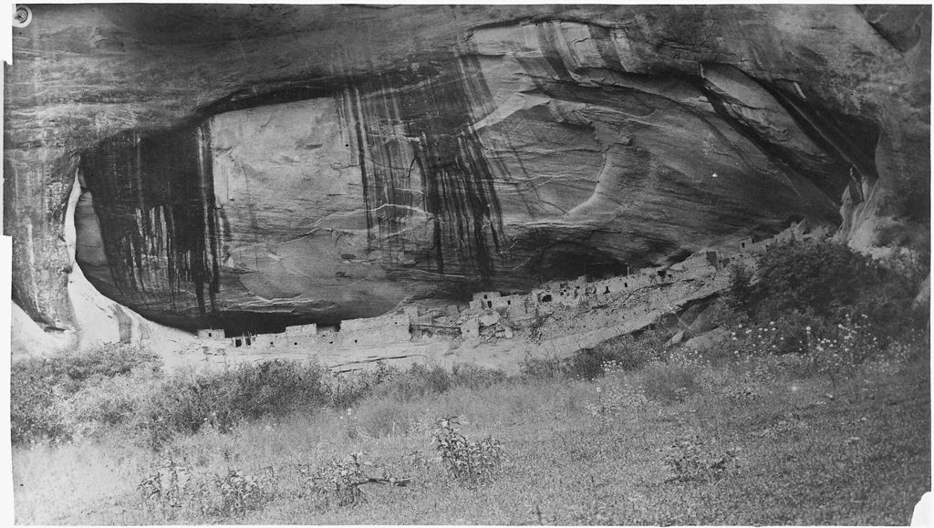
Situated within a natural shelter, high in a sheer cliff wall in Tsegi Canyon, Keet Seel (which means “Broken House” in Navajo) is an assemblage of 155 rooms built additively between the late 1240s and 1286, and abandoned by 1300 CE. The arc-shaped pueblo conforms to the curve of the cave in which it was built, as its one- to two-story height and terraced appearance is due to the natural slope of the cave floor. At peak population, there were as many as 150 people dwelling within the pueblo’s sandstone masonry and jacal walls. The rooms were built as clusters, with one dwelling space and one to six storage spaces per family, adjacent to a courtyard. These dwelling blocks sometimes included mealing rooms, in which grain was prepared. Circular kivas were used as ceremonial spaces; Keet Seel had five originally, situated in the center, near the rim, with a sixth kiva was erected on the canyon floor below. The pueblo also had a multistory, circular tower that rose from the canyon floor, and six semi-enclosed courtyards. The eastern half of the pueblo was built (c. 1275 CE) atop an artificial terrace composed of fill and buttressed by a massive retaining wall that is 180 feet long and as much as ten feet high in some places.
Located six miles from Keet Seel, Betatakin (meaning “House Built on a Ledge” in Navajo) is a cliff dwelling situated in an enormous alcove (measuring 452 feet high and 370 feet wide) located approximately 55-65 feet up the canyon wall. Here, the room blocks are enclosed by walls of rough-hewn sandstone adhered with clay mortar and sometimes coated with plaster. Many interior walls were made of jacal, a technique in which upright posts measuring five to ten centimeters in diameter are evenly positioned, the interstitial spaces are filled with smaller sticks and reeds, and the whole is heavily covered with mud, the surface of which is then smoothed. Roof beams were hewn from timber. With 135 rooms, Betatakin held as many as 100 people. Dendrochronological analysis has shown that three room clusters were built in 1267 CE, while a fourth was built the following year. Ten additional room blocks and one or two kivas were built between 1275 and 1277 with beams that had been cut in standard sizes and stored between 1269 and 1272, which suggests that the occupants were preparing for a population surge. This double building campaign gives Betatakin a more cohesive, ordered appearance than the heterogenous construction at Keet Seel, which was built in multiple stages. As at Keet Seel, however, construction ceased at Betatakin in 1286 CE and the pueblo was abandoned by 1300 CE. Inscription House, with 77 rooms, follows the same pattern.
The administration of Navajo National Monument was transferred to the National Park Service (NPS) soon after its founding in 1916, but the monument was neither funded nor promoted by the NPS until the early 1930s and even then, it was eclipsed by other monuments and parks in the Four Corners area. In 1933–1934, a Civil Works Administration labor crew stabilized rooms at Keet Seel. In 1939, Civilian Conservation Corps laborers, mostly drawn from the local Navajo population, built a rustic, two-room cabin as an office and visitor kiosk. Significant development projects did not begin at Navajo National Monument until the post–World War II era, when newly constructed roads brought automotive vehicles closer to the isolated canyon sites.
Until 1957, the park lacked even basic visitor facilities. But with the initiation of the NPS Mission 66 program, a new visitors’ center was proposed at Betatakin, which, following the construction of a nine-mile, paved approach road, now replaced Keet Seel as the main tourist entrance. Designed by the NPS Western Office of Design and Construction, the Betatakin Visitor Center was built between 1963 and 1964 on a canyon rim upon Navajo land. The Ganado Construction Company supervised the work. The modernist building, designed to complement the surrounding rocky landscape, includes a museum and Navajo folk-arts gift shop. By 1968, the park service had also completed two campgrounds at Navajo National Monument, along with employee housing, support infrastructure, and an overlook platform built at the end of the Sandal Trail leading to Betatakin.
References
Allaback, Sarah. Mission 66 Visitor Centers: The History of a Building Type. Washington, D.C.: United States Department of Interior National Park Service, 2000.
Ambler, J. Richard. “Navajo National Monument,” Navajo County, Arizona. National Register of Historic Places Registration Form, 1988. National Park Service, U.S. Department of the Interior, Washington, D.C.
Plog, Stephen. Ancient Peoples of the American Southwest. London: Thames and Hudson, 1997.
Rothman, Hal K. “Navajo National Monument: A Place and Its People. Administrative History” Washington, D.C.: National Park Service, 1991.