

Mule Canyon Towers
You are here
Cave Towers
1150–1350, Ancestral Puebloan. UT 95, 0.3 miles west of mile marker 103.
-
 (Photograph by Shundana Yusaf)
 -
 (Photograph by Shundana Yusaf)
 -
 (Photograph by Shundana Yusaf)
 -
 (Photograph by Shundana Yusaf)
 -
 (Photograph by Shundana Yusaf)
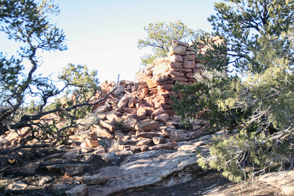
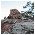
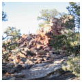
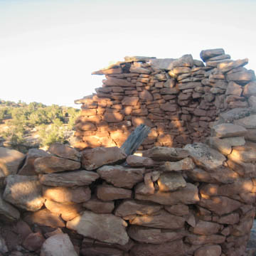
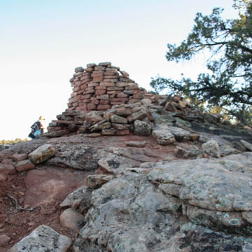
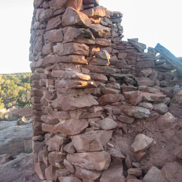
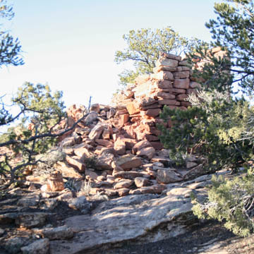
Cave Towers is one of the most substantial tower complexes in Utah after Hovenweep National Monument. It consists of five towers clustered around a permanent spring just below the rim of Mule Canyon. These towers are accompanied by a series of alcove room blocks, isolated rooms, two kivas, and a midden. Remains of possibly two additional kivas and two rectangular rock alignments suggest there were also rooms along the rim.
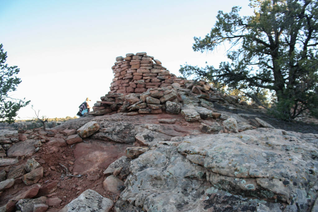
Four out of the five towers are circular detached towers with multiple courses of intact masonry, while the rubble of the fifth suggests it had a square plan. Tower 1 is located along the east rim of the western finger of Mule Canyon, while Tower 2 overlooks the finger of Mule Canyon approximately 30 meters downslope towards the north of Tower 1. Tower 3, in turn, stands at the head of the side canyon where the spring is located. Tower 4, the only square structure in the group and the only one in a state of near total ruin, would have risen across from Towers 1 and 2 on the other side of the canyon toward the southwest. Lastly, Tower 5 is found on an uplifted bedrock outcrop set back 12 meters from the eastern rim of the canyon and is situated east of an aboveground kiva structure. It is visible from across the canyon.
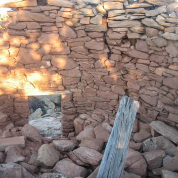
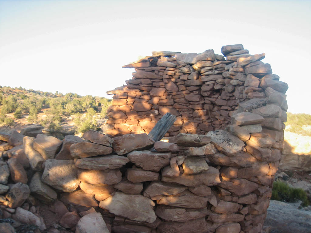
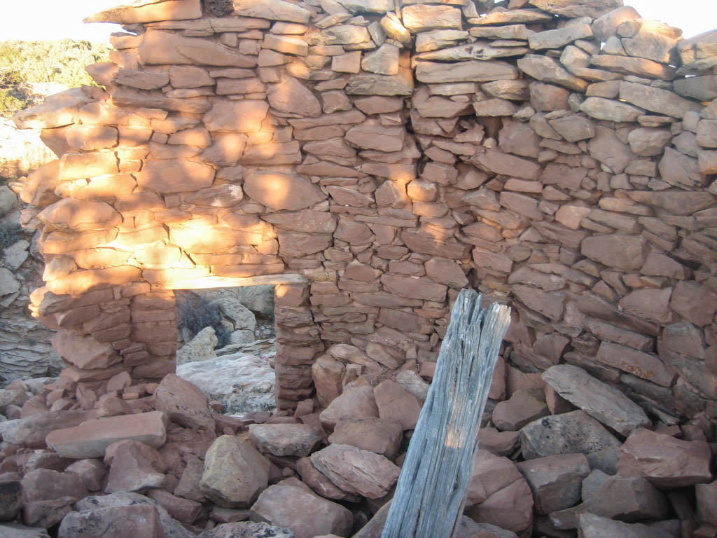
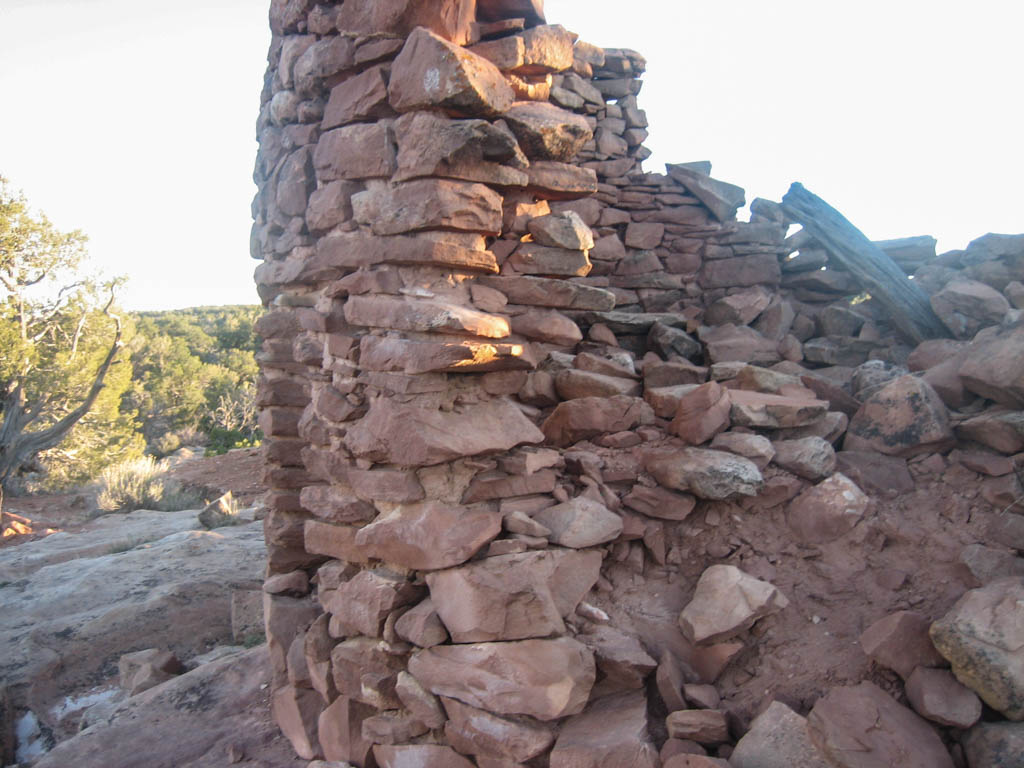
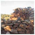
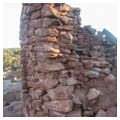
The structures rise straight from the bedrock and the walls were built from shaped and unshaped sandstone blocks and slabs. All the extant walls have wet-laid core and veneer masonry. Towers 2, 3, and 5 supplement this technique with sandstone spall and chinking stones in the mortar. The average thickness of the walls varies between 50 and 70 centimeters.
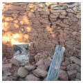
The doorway of Tower I is intact and faces southeast along the rim. Measuring 65 centimeters wide and 1.3 meters tall, the base of the doorway is 50 centimeters above the foundation. Seven wooden lintel beams are still in place. There is no remaining evidence of entryways at Towers 2, 4, and 5. A possible entryway is located on the east side of Tower 3, but is obscured by rubble with remains of lower left and right jambs. Although the lower portion of the entryway is missing, it is estimated that the opening width was 60 centimeters.
The height and the width of the towers vary. The interior diameter of Tower I is 2.5 meters while that of Towers 2 and 3 is 3.5 and 4.5 meters, respectively. It is difficult to provide an estimate for the last two structures. In terms of height, it is estimated that the first of the five towers originally stood at four meters, the second and third at two meters, and the fourth between two and three meters high. The three-meter-tall standing masonry of the last tower along the west arc suggests that it could not have been higher than this.
Tower I is filled with over a meter of fallen wall. Its southeast side stands four meters high while the northern side has collapsed, with rubble crumbling downslope into the canyon. Since there are no visible sockets for supporting logs in any of the standing walls, it seems to have been a single-story structure. The rubble inside the tower suggests that it probably had a roof made out of beam sticks. In the other four towers, there is no evidence of roofing. A low, arced wing wall that opens toward the canyon rim on the east abuts the tower on the southern side. Built on bedrock, the foundation of this wall is intact although disturbances have dislodged all of the coursed masonry. There appears to be no preparation of the stones used in construction. Since there is no intact masonry, the width of the original wall is unclear, as is the masonry technique utilized. The wall extends off the western arc of the tower and continues 2.5 meters before turning north. The north wall arcs and abuts the north wall of Tower 1. The interior diameter measures 2.5 x 3.5 meters. In 1968, Weber State College cleared around the base of Tower 1 and piled up the rubble and wall fall into a berm to the south, west, and east of the tower.
Tower 2 displays three courses of an intact wall along the north arc of the structure. Scant rubble suggests that the structure was low to the ground. Tower 3 is predominantly a rubble mound yet intact coursing is present and exposed along portions of the northern arc of the structure. Rubble has been cleared from the northeast exterior of the structure, exposing 13 to 15 intact courses that stand two meters in height. Tower 3 is abutted to the west by a low wing wall. No intact masonry remains, but the wall alignment extends approximately two meters to the west. The present-day remains of Tower 4 include wall fall, temporary stone alignments, and two visible 50-centimeter portions of coursed stone alignments. An L-shaped retaining wall connects Tower 5 with an aboveground kiva. The latter is four meters downslope to the west and abuts another aboveground kiva structure, 1.3 meters to the south.
All five towers have a similar view stretching primarily to the south, looking directly down the canyon. The Chuska Mountains can be seen from many of the towers and it is likely that, at their original height and without the present day vegetation, one could see the Sleeping Ute Mountain in the distance. All five are in view of one another. Almost all of them have a direct view into the spring. It is possible that at times these towers served as a marker or monitor for the water source, perhaps reinforcing water claims and limiting access to the spring. To access the spring, one must pass through the cluster of towers at the canyon rim or be watched from above while at the spring location.
Despite their relatively isolated location, in recent years the Cave Towers have become a popular destination for campers and hikers drawn to their powerful sentry-like forms. Out of concern for the stability and archaeological integrity of the Cave Towers, the Utah School and Institutional Trust Lands Administration, which manages the site, has installed boundary markers and interpretive signs.
References
Bradley, Richard. The Significance of Monuments: On the Shaping of Human Experience in Neolithic and Bronze Age Europe. New York: Routledge, 1998.
Bredthauer, Alison Vanessa. “A Towering Enigma: An Examination of Late Pueblo II and Pueblo III Towers in the Northern San Juan Region.” Master’s thesis, University of Colorado, 2010.
Churchill, Melissa, Kristin Kuckelman, and Mark Varien. “Public Architecture in the Mesa Verde Region.” Paper presented at the 63rd Annual Meeting of the Society for American Archaeology, Seattle, Washington, 1998.
Green, Dee. Archaeological Survey on Cedar Mesa, Southeastern Utah 1968. Weber, UT: Weber State College, 1969.
Smith, Earl. “AR-43-06-33: Archaeological Site Inventory.” San Juan County, Bureau of Land Management Office, Monticello, Utah, 1964.
Smith, Earl. “42SA5024: Archaeological Site Inventory.” San Juan County, Bureau of Land Management Office, Monticello, Utah, 1968.
Van Dyke, Ruth M., and Anthony G. King. “Connecting Worlds: Pueblo III Towers in the Northern San Juan.” Kiva 75, no. 3 (2010): 349-372.
Van Dyke, Ruth M. “Chaco Reloaded: Discursive Social Memory on the Post-Chacoan Landscape.” Journal of Social Archaeology 9, no. 2 (2009): 220-248.
Writing Credits
Coordinator:
Shundana Yusaf
If SAH Archipedia has been useful to you, please consider supporting it.
SAH Archipedia tells the story of the United States through its buildings, landscapes, and cities. This freely available resource empowers the public with authoritative knowledge that deepens their understanding and appreciation of the built environment. But the Society of Architectural Historians, which created SAH Archipedia with University of Virginia Press, needs your support to maintain the high-caliber research, writing, photography, cartography, editing, design, and programming that make SAH Archipedia a trusted online resource available to all who value the history of place, heritage tourism, and learning.