

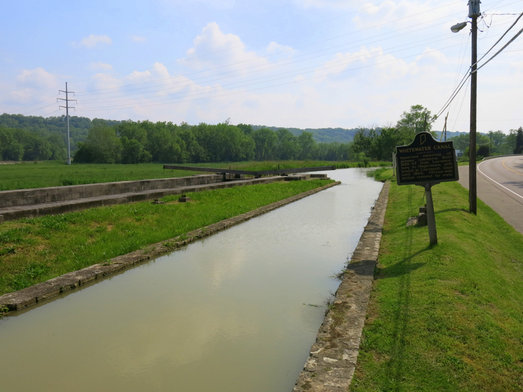
Whitewater Canal
You are here
Whitewater Canal State Historic Site


1836–1847; c. 1945–1950, restoration. Metamora vicinity.


The remaining fragments of the Whitewater Canal are significant as intact examples of nineteenth-century canal engineering and hydraulic power systems. The canal represents Indiana’s Internal Improvement Era, which helped to increase the population and economy of the Whitewater Valley, transforming it from a pioneer society to one based on industry with connections to other regions in Indiana and Ohio. It was constructed via a public-private partnership, which became the model followed for the construction of railroads and other public infrastructure in the state.
The design of the canal and its locks, feeder dams, and aqueducts was not unique; it followed precedents set by canal projects in the eastern United States, particularly the Erie Canal (1817–1825), which, in turn, followed precedents set by the ancient construction of artificial waterways that can be found on almost every continent. The completion of the Erie Canal gave other regions in the country the confidence that such improvement projects could be successfully completed. In Indiana’s Whitewater Valley, residents began discussions about a canal that would connect them to Cincinnati, as moving goods and agricultural products along the Ohio River was dangerous and expensive and road conditions were generally poor. The idea was first formally presented in 1822, when Brookville attorney and Indiana Senator James Brown Ray proposed that the State of Indiana build a canal parallel to the Whitewater River (which was difficult to navigate) from Brookville to the Ohio River near Lawrenceburg. The idea was well received, but funding was not available.
In 1825, representatives from Dearborn, Fayette, Franklin, Randolph, Union, and Wayne counties met in Harrison, Ohio, to discuss the feasibility of a canal that would stretch from the Ohio River to Hagerstown, Indiana, considerably farther than originally proposed by Senator Ray. The representatives understood that, with the lack of federal or state funds, the project would not be possible without a public-private partnership. The Indiana General Assembly of 1825–1826 granted a charter for the Whitewater Canal Company and called for the sale of 40,000 shares of stock at $25 a share. The charter gave the company the ability to receive state and federal funding, but it was also able to raise private funds.
Survey work on the potential canal route started in 1829. Seventy-six miles were surveyed between Nettle Creek in Wayne County and Lawrenceburg, Indiana. The survey revealed that the route would fall 491 feet in just 76 miles, a change in altitude that is less than ideal for canals. The route would require 56 locks, 7 feeder dams, and 12 aqueducts to carry the canal over streams. The estimated cost of construction was between $1.1 million and $1.4 million. The canal’s construction was divided into over 100 sections, with different contractors responsible for each and dozens of engineers and over a thousand laborers needed. Construction contracts were first signed in 1836. Progress stopped and started several times due to lack of funds and flooding, but was finally finished by about 1847.
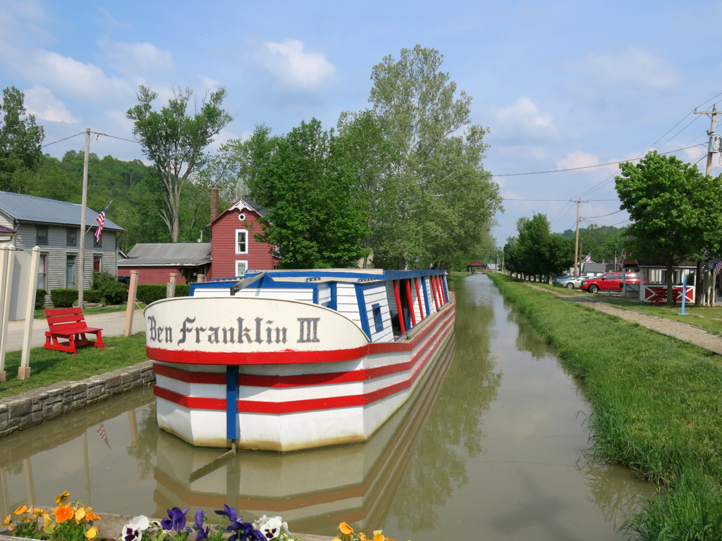
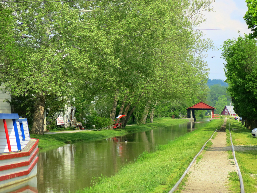
The canal generally parallels the course of the Whitewater River, which is located west of the canal and flows in a southeasterly direction. It originally included a channel and a towpath. (Part of the towpath was later used as a railroad bed.) Although it resembles a small stream in most locations today, the channel was originally 40 feet wide at the water line, 26 feet wide at the bottom (the channel’s sides were slanted), and had a depth of 4 feet. Boats in the channel were pulled by horses dragging the boats from the towpath. Travel along the canal was slow, especially because of the high number of locks (56) located along its length.
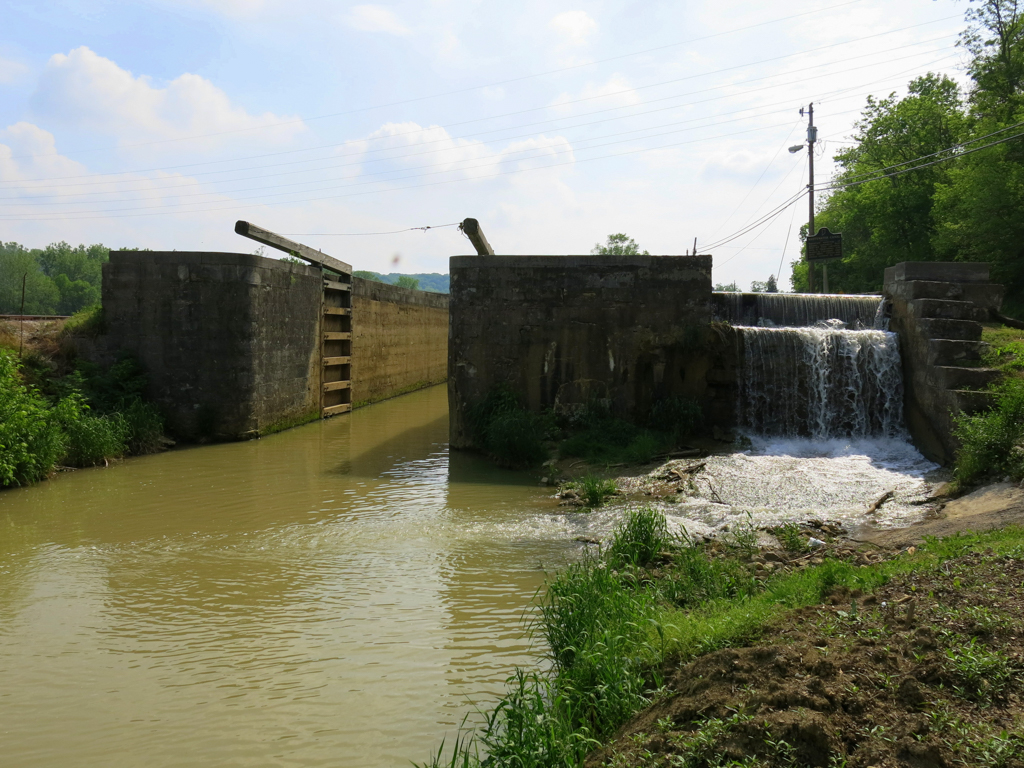
Designs for the locks were standard, with some subtle variations in construction depending on the judgment of the independent contractors. All of the locks along the Whitewater Canal were made from limestone. Some of the internal chambers were lined with wood planks to help protect the stone blocks. This “composite lock” construction was used when the local stone was of slightly worse quality than desired.
The operation of the locks was simple. They featured an internal chamber about 15 feet long with a gate at either end. Each gate included levers below the water that could be opened or closed to let water in or out of the chamber. As an example, if a boat was traveling downstream, the boat would enter the chamber through the upstream gate with the downstream gate already closed. The upstream gate would be closed, the downstream gate levers would be opened, the water level inside the chamber would go down and the downstream gate would be completely opened, and the boat would proceed downstream. The process was reversed for upstream travelers. At the busier locks, lock tenders or managers were responsible for helping boats “lock through.” These individuals, who sometimes lived near their locks, were also responsible for collecting tolls. In rural areas, however, boat crews were responsible for locking themselves through.
Floods continued to plague the canal. Throughout the 1850s, the canal was shut down about as often as it was open. The resulting maintenance and repair costs forced the canal company to levy excessively high tolls. As a result, roads continued to be the preferred method for moving crops and other goods to market. By the 1860s, the canal era was supplanted by railroads; no boats were traveling along the channel by around 1865. The Indianapolis and Cincinnati Railroad purchased the canal in 1863. The state legislature gave permission to build a railroad over the towpath with the stipulation that the channel had to remain available for hydraulic power, since numerous mills along the canal’s length relied upon it.
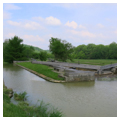
Although the canal was no longer used for transportation purposes, the locks continued to be the focal point for community life in the Whitewater Valley. Small towns developed near several of the locks, including Metamora at Lock 24. The locks created centers for milling, manufacturing, and trade. When water transportation on the canal ceased, the channel and its locks fell into disrepair. The hydraulic company that maintained the channel from 1866 to the late 1930s completed only the most basic repairs. As the middle years of the twentieth century approached, the Whitewater Canal seemed destined for ruin. That fate had already occurred to several canals that had been constructed in Indiana during the canal era. Dams, aqueducts, and locks crumbled and the channels deteriorated.
Residents of the Whitewater Valley began to take interest in the restoration of the canal because of its potential economic benefits from heritage tourism. The Whitewater Canal Association was formed and successfully lobbied for the creation of a state historic site along the remaining portion of the canal near Metamora. Between 1944 and 1946, the State acquired titles to 14 miles of the former canal. However, most of the channel was but a small stream, the Laurel Feeder Dam was broken, and the locks north of Lock 25 were in ruins. The Indiana Department of Conservation (now the Department of Natural Resources) set about restoring the Laurel Feeder Dam, the Duck Creek Aqueduct, Locks 24 and 25, and a short section of the canal’s channel south of Lock 24.
Today, the Whitewater Canal State Historic Site interprets several canal-related resources that are open to the public. The Metamora Mill, located at the restored Lock 24, is operated via hydraulic power from a reconstructed water wheel inside the lock chamber. Lock 25 and the Duck Creek Aqueduct (a National Historic Civil Engineering Landmark) have both been restored. Visitors can also take a peaceful canal boat ride between Locks 24 and 25 to gain a sense of what canal transportation was like in the nineteenth century.
The remains of the Whitewater Canal between the Laurel Feeder Dam and Metamora offer a valuable opportunity to study the history of American engineering, transportation, agriculture, commerce, and manufacturing within a relatively short expanse. Influenced by the Industrial Revolution, canals such as the Whitewater Canal drove the American economy, shaping the country’s culture and strengthening its position within the global economy. Few other canal sites in the Midwest offer the array of historic materials within their original context and setting that the Whitewater Canal presents.
References
Center for Historic Preservation, Ball State University for the Divisions of State Museum and Historic Sites and Historic Preservation and Archaeology, Indiana Department of Natural Resources. Interim Historic Structure Report for the Whitewater Canal between the Laurel Feeder Dam and Metamora, Indiana. 2006. Available in the Drawings and Documents Archive, Ball State University, Muncie, Indiana.
Writing Credits
Coordinator:
Benjamin L. Ross
If SAH Archipedia has been useful to you, please consider supporting it.
SAH Archipedia tells the story of the United States through its buildings, landscapes, and cities. This freely available resource empowers the public with authoritative knowledge that deepens their understanding and appreciation of the built environment. But the Society of Architectural Historians, which created SAH Archipedia with University of Virginia Press, needs your support to maintain the high-caliber research, writing, photography, cartography, editing, design, and programming that make SAH Archipedia a trusted online resource available to all who value the history of place, heritage tourism, and learning.