


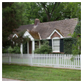


The fact that Mooresville’s self-conscious “quaintness” may, in a sense, be more apparent than real is actually one of the remarkable qualities of this tiny village, population 53 according to the 2010 census. Against daunting odds—it is located near two busy interstate corridors and faces urban encroachment as the vast surrounding cotton fields disappear—Mooresville’s residents have worked vigorously to maintain the languid, leafy charm of another age. The town’s picket fences and quiet lanes were, in fact, seductive enough for Disney Productions to use it as the setting for a 1995 television remake of the classic Tom Sawyer, with Mooresville doubling as Tom’s Missouri hometown and the nearby Tennessee River as the Mississippi.
Until the 1950s, time did indeed seem to stand still in Mooresville. Two-lane State Highway 20 from Decatur brushed by the village and then dog-legged unhurriedly around spreading fields of cotton on through the neighboring hamlets of Belle Mina, Greenbrier, and Madison, before heading a few miles northeast to Huntsville, then a small city of some 20,000 people. But things changed quickly with the coming of Huntsville’s space industry. As the city mushroomed, State Highway 20 was widened and realigned as a razor-straight, four-lane connector between Huntsville and nearby Decatur. A few years later came the construction of I-65, bringing with it a major interchange less than a mile west of the village. Development has intensified in the years since, with master planning tilted more toward industrial development and tract housing than landscape conservation. Nevertheless, Mooresville, buffered on the south by the large Wheeler Federal Wildlife Refuge, has maintained its physical presence as a place of singular character in the state, with narrow tree-lined streets as well as an instructive palette of mostly domestic architecture from the early 1800s to the late twentieth century.
Though official federal land sales did not get underway until 1818, the two brothers for whom Mooresville is named had “squatted” here (the frontier term for unauthorized possession of government lands) as early as 1808. Close to the Tennessee River, with natural springs and fertile land all about, it was a promising locale. A settlement took root, with incoming Tennesseans, Virginians, Georgians, and Carolinians; a tiny grid of streets was platted; and in October 1818, forty residents petitioned the legislature of the Alabama Territory for incorporation as a town—a measure approved a month later. In the two centuries since, the grid and the boundaries have remained unchanged. Today, some half a dozen structures survive from the first two decade or so of the town’s existence.
Mooresville’s population peaked at about 200 souls in the late 1800s. It was a close-knit community made up of large landowners who cultivated the surrounding fields; a few storekeepers and craftsmen; a handful of professionals, including doctors, teachers, ministers; and the African American household domestics who helped sustain daily life in a southern town. The village had a wagon maker and a blacksmith shop, two brick stores, and two churches. Until its building was cannibalized for construction materials by Union troops encamped around the village during the Civil War, Mooresville also boasted a “female academy.”
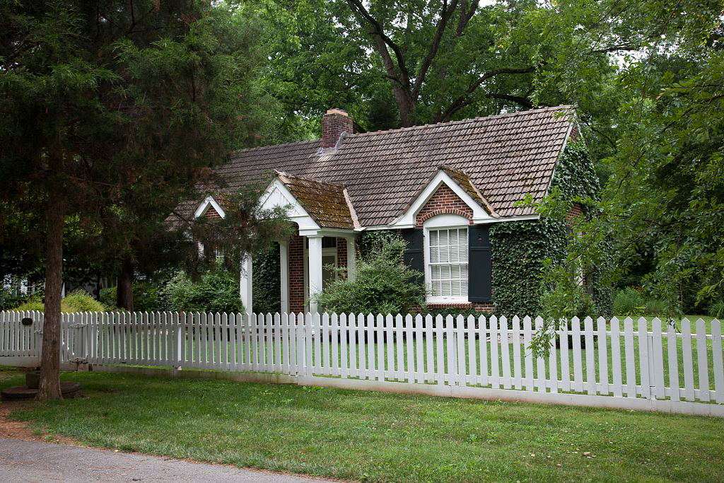
During the 1930s, inspired by the restoration work underway at Colonial Williamsburg and local documentary efforts by the Historic American Buildings Survey (HABS), Mooresville residents began to take note of their own village’s special character. No doubt this is due in large part to Carolyn Cortner Smith, allegedly Alabama’s first woman architect. With WPA funding, she oversaw the restoration of Decatur’s 1836 State Bank Building. And with strong family ties to Mooresville, she designed its largest residence in a simple “period” manner, with pillars and a graceful fanlight doorway. Smith’s guiding hand also seems evident in other tasteful renovations and improvements that occurred in Mooresville during the 1930s and 1940s. Especially noteworthy is the circa 1940 Zeitler Museum, erected on the grounds of the early-nineteenth-century McCrary-Peebles House to contain the collection of avid local historian Henry Zeitler.
In 1972 Mooresville became the first Alabama historic district to be listed on the National Register of Historic Places. Unfortunately, the later twentieth century saw attrition as well, particularly the loss in 1970 of the singular Minor-Hundley House, a rare Deep South example of a dormered, Virginia-type brick cottage.
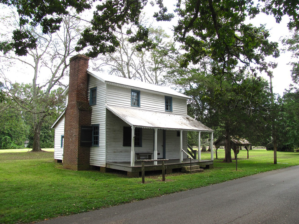
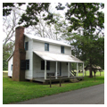
Some of the town’s earliest structures include the circa 1825 Stagecoach Inn and Tavern, measured and photographed by HABS in the 1930s and restored in the 1980s, as well as the Peebles Brick Store (circa 1826), adaptively renovated as a residence in 1936. At least three dwellings also survive from the same period, including the Peebles-McCrary and Campbell-Woodroof houses (notable for their well-maintained collection of dependencies, including a brick kitchen and log smokehouse) and the Thomas Thach House, which was heavily refurbished in the 1990s and was the location where future U.S. President Andrew Johnson boarded as an apprentice tailor in the village. A fourth house, the massively chimneyed Scott-Yarbrough Cottage, now lies in ruins—a victim of demolition by neglect after being restored in the 1960s. It is believed to be the oldest house in the village.
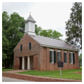
At the brick Union Church (1839) where the village gathered for worship, a recessed portico once accommodated an outside stair leading to the now sealed-off slave gallery. A heaven-pointing wooden hand atop the belfry replicates a lost original and was placed there in 2000. In the meetinghouse built in 1854 by the town’s Disciples of Christ congregation (later the Mooresville Church of Christ), Brigadier General and future President James A. Garfield preached in the spring of 1863 while his Ohio regiment was encamped nearby. Quaker-plain in the beginning, the building was renovated and acquired its present simple bell tower around 1900.
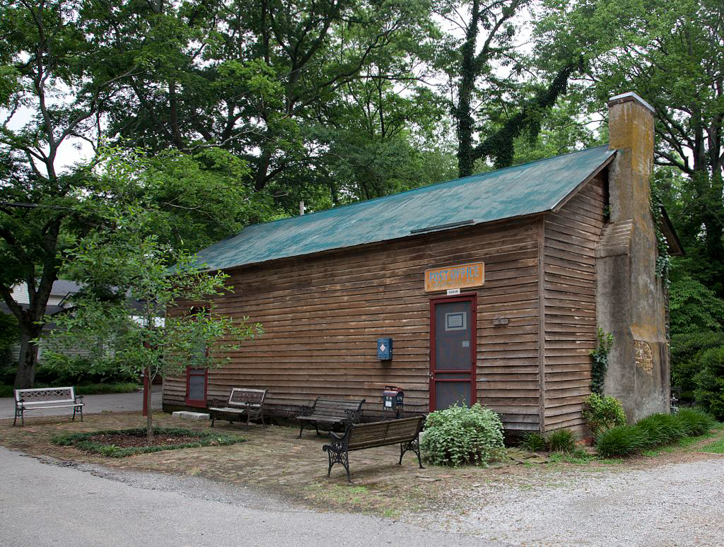
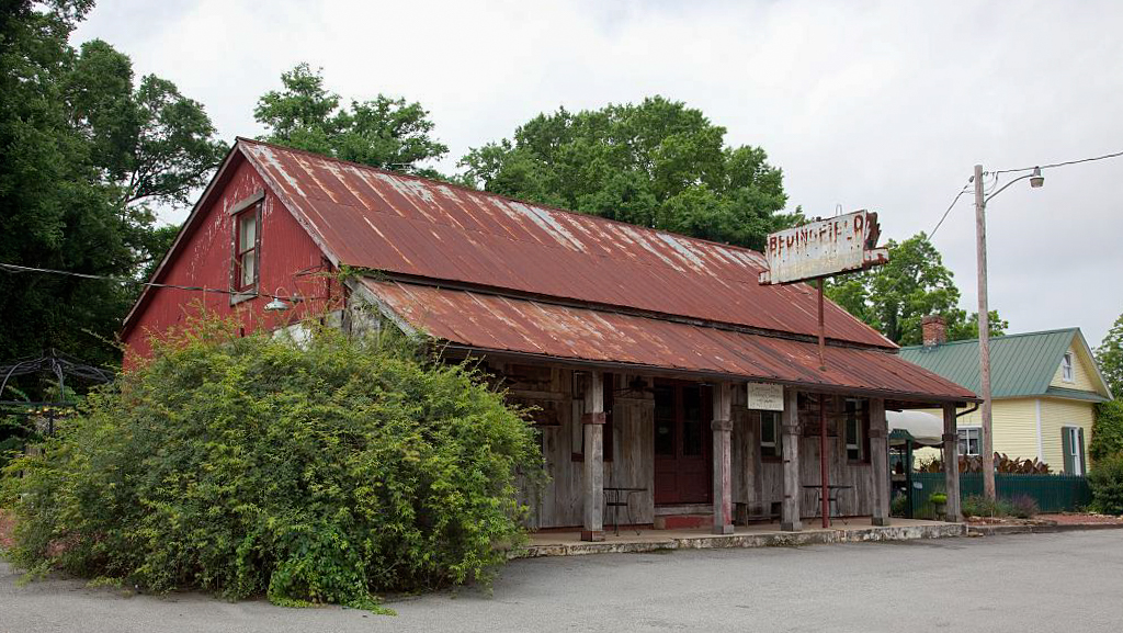
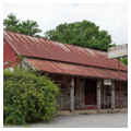
The construction date of Mooresville’s picturesque combination store and post office, a duo often seen in rural early America, has been a subject of dispute, though physical evidence would seem to suggest the mid-nineteenth century. Built in the late nineteenth century was the diminutive Zach Simmons House (circa 1890), erected by an African American carpenter as his own residence. Restored in 2012 as a gift shop, the cottage is distinguished by its trellised front porch and “catslide” roof sloping downward across the rear. Reputedly from about the same time period is the Bedingfield Store (now a popular eatery) with its long front porch.
Additions to the village landscape since the 1980s have veered toward a freewheeling architectural historicism that includes a “Louisiana cottage,” a New England saltbox, and a hipped-roof Italianate house (circa 1870) rescued and relocated from Decatur in the 1970s, then later fitted out with a Charleston-type side entry onto the veranda. Some ventures are more successful than other. Purists may quibble over issues of architectural appropriateness as Mooresville continues to evolve. But the counter argument might be offered that, within the broader bounds of an informed respect for landscape, materials, and scale, this is the sort of dynamic that continues to make one of Alabama’s oldest communities also one of its most intriguing.
References
Axford, Faye Acton, and Chris Edward. Lure and Lore of Limestone County: Alabama Antebellum Houses and Families. Birmingham, AL: Portals Press, 1978.
Gamble, Robert. Alabama Catalog – Historic American Buildings Survey: A Guide to the Early Architecture of the State. Tuscaloosa: University of Alabama Press, 1987. Guide to Mooresville records. Division of Prints and Photographs, Library of Congress, Washington, D.C.
Jones, Virgil Carrington (“Pat”). “Mooresville.” Unpublished compilation of undated articles appearing in the Huntsville Times during the 1930s. Private collection of Robert Gamble.