


Established by presidential decree in 1924, Chiricahua National Monument is a 10,000-acre wilderness reserve located 120 miles southeast of Tucson. Though unique geological formations are what attract visitors to the reserve, the park is also notable for its use of the naturalistic landscape design principles and rustic architectural idioms that federal agencies employed frequently during the interwar decades.
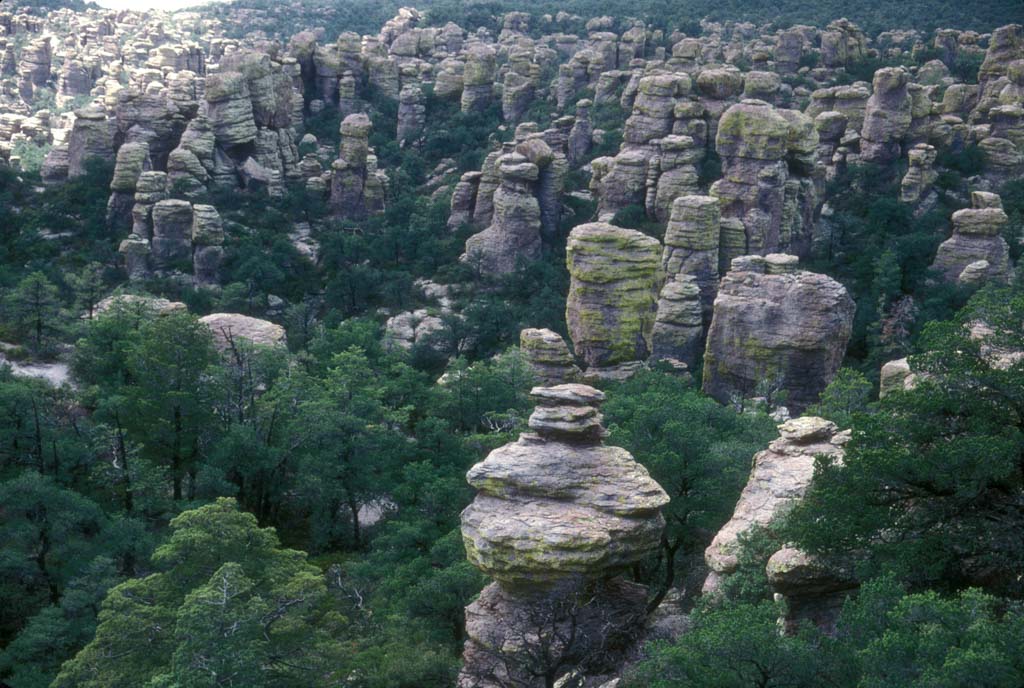
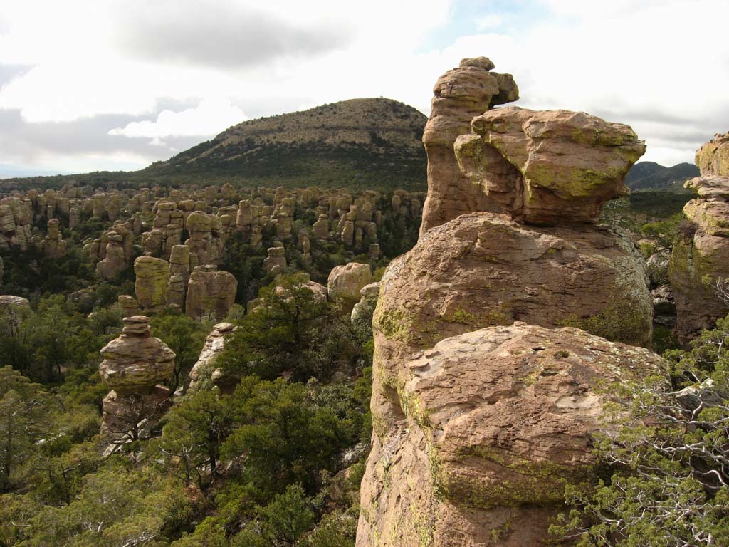
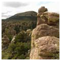
Located in the northwestern Chiricahua Mountains, the landscape marked by shallow caves, faults, and lava flows is a confluence of four ecological regions: the Sonoran and Chihuahuan deserts with the Rocky Mountain and Sierra Madre ranges. Floral and faunal biodiversity thrive in this liminal space, which is densely covered with various pines, firs, spruces, sycamores, oaks, and cypresses as well as yucca, cholla, cacti, and ferns. The reserve is best known for the “Wonderland of Rocks,” a natural assemblage of towering rhyolite columns, the eroded forms of which bear such fanciful names as Organ Pipe, China Boy, and Sea Captain. These precariously balanced pinnacles were formed 27 million years ago by the sequential eruptions of the Turkey Creek Caldera, sited eight miles to the south. According to an eighteenth-century Spanish Jesuit missionary, “Chiricahua” is an Opata native word for “wild turkey,” an allusion to the prevalent game in the area, which served as a seasonal hunting ground for the Chiricahua Apache in the late prehistoric and post-contact eras, until the tribe was forcibly removed in 1886. The Chiricahua Apaches considered the peculiar landscape a sacred site, traveling to the Wonderland of Rocks to converse with deceased ancestors and utilizing the natural gap of Bonita Canyon as an east-west transportation route.
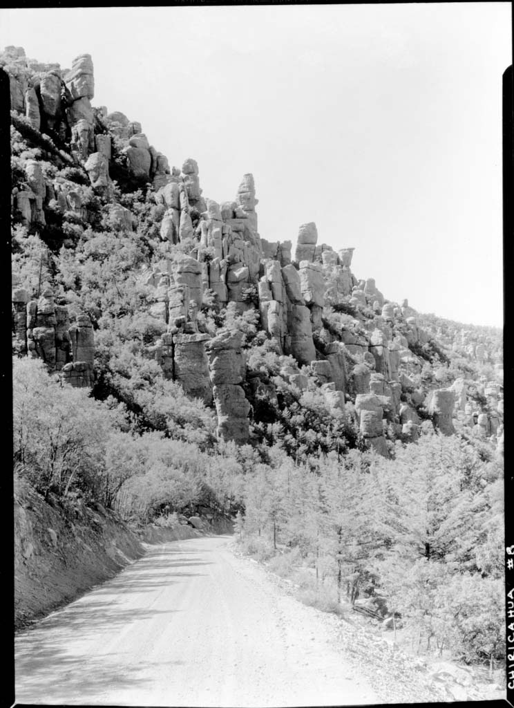
The U.S. Forest Service (USFS) managed the water and timber resources in the Chiricahua Mountains and, later, the national monument after its designation in 1902. In 1933 the monument was transferred to the National Park Service (NPS). Through the mid-twentieth century, the cultural landscape here was developed in three distinct phases beginning with the period 1924–1934, when the USFS established facilities with the assistance of neighboring rancher, Edward M. Riggs (1885–1950). Prior to 1929, Riggs constructed a series of trails and a short road from his Faraway Ranch to a campground within the new park for tourists’ convenience. Between 1932 and 1934, the USFS and the Bureau of Public Roads constructed Bonita Canyon Highway, the park’s main spine, as well as a spur to Massai Point, a slightly rounded plateau measuring 1,200 feet in diameter. Thanks to the elevated, panoramic vista it offers, Massai Point is a primary park destination and it still serves as the main counterpoint to the entrance on the park’s eastern side: all major trails originate at the Point and end at the Visitor Center.
The most significant period of development at Chiricahua occurred between 1934 and 1940, when NPS employees created a park master plan that included circulation routes (vehicular roads and foot trails) placed according to natural drainages and buildings sensitively designed to take advantage of the physical context. Directing these projects were NPS engineers J.H. Tovrea and Robert S. Harris, along with landscape architects Harry Langley, Charles Richey, Richard Sias, and Jerome C. Miller, and architects Robert W. Albers and Cecil J. Doty. Civilian Conservation Corps (CCC) laborers completed the work, upgrading Bonita Canyon Highway, constructing miles of hiking trails, and erecting several buildings for administrative, residential, utility, and visitor use until the CCC camp was disbanded in 1940. While they were active, the CCC used local materials (such as boulders or cut stone quarried on site) as well as poured concrete to construct the 8,500 feet of riprap and revetment, 225 feet of retaining walls, nearly 50 culverts, and other drainage devices. The 12 hiking trails the CCC built are located in the park’s southeastern corner where they encircle the most scenic areas within the reserve. Much CCC labor involved replanting the disturbed construction sites with materials collected from the surrounding landscape, as well as cutting down large trees from slopes to create calculated vistas. Between 1934 and 1935, they cleared the site for the public campground (laid out according to the “Meineke plan”), constructing its one-way loop road for cars, camp units, and two facilities. During the same period, CCC workers built Sugarloaf Lookout, the secondary destination within the park.
Structures and other built features were nestled into the existing landscape using compatible or matching materials, to make them as visually unobtrusive as possible. The original rustic-style Ranger Station, built by CCC labor between 1935 and 1937, was sited on a small ledge at the juncture of Rhyolite and Bonita Creeks; Richey oriented the new parking lot and footpath to the facility on the wide floodplain along Rhyolite Creek’s south bank. For Massai Point, Doty, who headed the NPS’s Southwest Regional office, designed the hexagonal Orientation Station (1939) in a quintessential rustic style using on-site materials so that the building would blend into its environment. The 16-foot-diameter structure features exterior walls of rough-hewn rhyolite blocks and mortar. A rustic amphitheater and platform (known as the Speaker’s Rock), were also built on Massai Point at this time. These facilities were used for events like the Dedication Ceremony that celebrated the opening of Bonita Canyon Highway on September 3, 1934. The amphitheater was formed from a natural depression, a shallow slope that had unobstructed views of the Wonderland of Rocks to the southwest: boulders were cleared from the slope, vegetation mowed, and a series of paths constructed to a rock-walled seating area featuring cut stone seats, steps, and flagstone pavers.
The final phase of development occurred after World War II during the NPS’s Mission 66 project, which updated facilities using contemporary design principles, modernist formal idioms, and modern materials and technologies. Mission 66 favored sleek and streamlined buildings and roads (even when they included naturalistic materials) and an emphasis on landscape views. At Chiricahua, the amphitheater’s seating area was expanded to the north in 1953 and a telescope was added to the lower platform the following year. In 1962–1963, Doty designed the modernist addition to the 1935 Visitor Center, which now includes an assembly of separate units built over a 30-year span. That same year, the wooden guardrails the CCC erected along Bonita Canyon Highway were replaced with metal rails. Between 1967 and 1969, the road itself was paved with asphalt and pullouts were constructed. After neighboring Faraway Ranch and Silver Spur Meadow were purchased in the 1960s and 1970s, trails were constructed to provide access between these historic homesteads and the lower half of the park. In 1976, Congress passed an act preserving 87 percent of the national monument’s land as undevelopable wilderness. Since then, all development has occurred on already disturbed park acreage, such as the new picnic area built at Faraway Ranch in 1990. Because of its multiple and significant layers of development, the historic designed landscape of Chiricahua National Monument was listed in the National Register of Historic Places in 2008.
References
Allaback, Sarah. Mission 66 Visitor Centers: The History of a Building Type. Washington, D.C.: U.S Department of Interior National Park Service, 2000.
Pinto, Robin Lothrop, R. Brooks Jeffery, and Mike Lovato. “Chiricahua National Monument Historic Designed Landscape,” Cochise County, Arizona. National Register of Historic Places Registration Form, 2008. National Park Service, U.S. Department of the Interior, Washington, D.C.