


Wupatki National Monument is an archaeological preserve straddling the southern edge of the flat, arid Colorado Plateau. The 35,422-acre park, some 33 miles northeast of Flagstaff, lies adjacent to Sunset Crater Volcano and Walnut Canyon national monuments, forming a vast and contiguous cultural preserve encompassing upland prairies, canyons, Ponderosa pine forests, the Painted Desert, and a volcanic field, as well as thousands of prehistoric and historic archaeological sites. The land lies at the heart of the ancestral homelands of both Hopis and Navajos, and the larger ruins within the park are some of the region’s best-preserved examples of prehistoric, Ancestral Puebloan architecture. At the same time, Wupatki also includes fine examples of National Park Service (NPS) architecture of the twentieth century, embodying the changing philosophies and styles of the NPS in the decades after it took over the park’s administration in 1934.
The Sunset Crater volcano erupted beginning in 1064 CE and recurring over several decades, covering the surrounding area in an ashy loam that fostered vegetation. In the late eleventh century, three prehistoric, Ancestral Puebloan peoples—the Sinagua, the Cohonina, and the Kayenta Anasazi—began to settle and intensively farm this land, building terraces and bordered gardens to cultivate maize and squash without extensive irrigation. The settlers dwelled in pithouse villages and masonry pueblos in the low-lying areas and in fortified cliff dwellings.
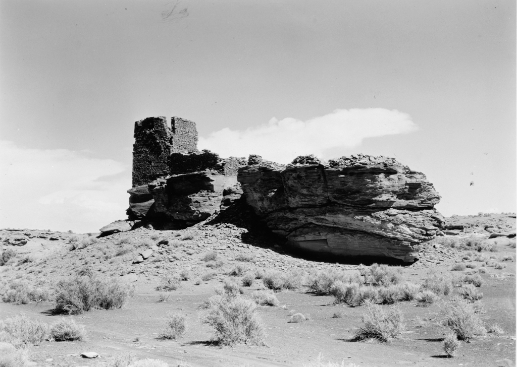
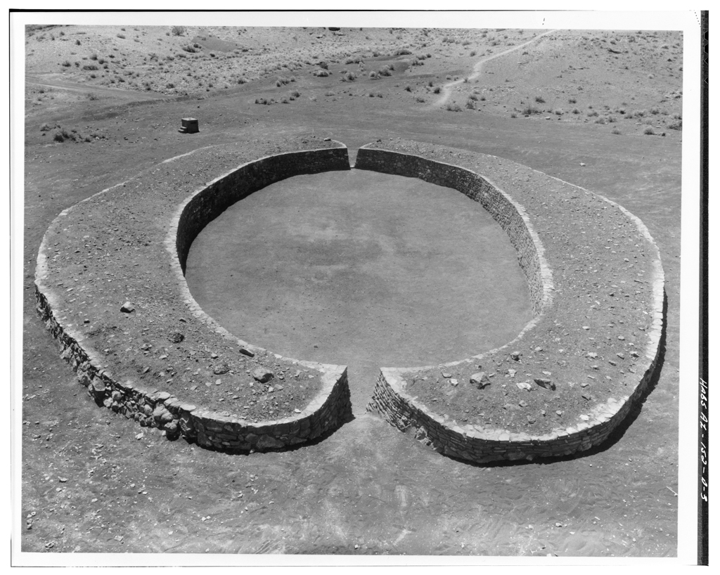
Wupatki has ten large pueblos including Wupatki, the Citadel, Wukoki, Lomaki, Campground Ruin, and Crack-in-Rock. Comprising freestanding walls of thin, local red sandstone blocks, the pueblos were mostly one- and two-story structures. The largest of these pueblos is Wupatki (meaning “Tall House” in the Hopi language), which the Sinagua culture built against a mesa wall between 1100 and 1190 CE. Containing over 100 rooms, Wupatki comprises two multistoried, elongated room blocks connected by a pair of tiered rooms. The pueblo also has a circular, masonry amphitheater; a ball court; and two kivas. At Wupatki’s peak at the turn of the thirteenth century, approximately 85-100 residents dwelled here. The second largest pueblo in the park is the Citadel with more than 50 rooms. Situated atop a mesa, the ruined masonry walls enclose a centralized plaza with a kiva. Despite a century of occupation, these prehistoric settlements were abandoned by the mid-thirteenth century and the pueblos were left to ruin.
Wupatki was first “discovered” by Lorenzo Sitgreave’s military expedition through the Little Colorado River Valley in 1851, although historic occupation of the area began circa 1860, when an extended family of Navajos, all related to Peshlakai Etsidi, resettled the area. Anglo-American ranchers, miners, traders, and shepherds also utilized the area throughout the nineteenth and early twentieth centuries. Archaeological interest in Wupatki began in 1885 when Major John Wesley Powell, founder of the U.S. Bureau of American Ethnology (BAE), visited the area. In 1900, archaeologist Jesse Walter Fewkes mapped and photographed the largest ruins, including Wupatki Pueblo and the Citadel. Two decades later, in 1924, President Calvin Coolidge established Wupatki National Monument on 2,200 acres, helping to protect these valuable ruins.
When the preserve was transferred to the NPS in 1934, the agency immediately began a building program in conjunction with the Mount Elden Camp of the Civilian Conservation Corps (CCC). The CCC developed many of the park’s trails, roads, and early facilities. Designed by NPS landscape architects in a rustic idiom, the infrastructure was planned to blend with the natural landscape: construction materials were quarried on site and flat, sandstone slabs—like those employed in the ancient pueblos—were the primary building blocks. In the early 1940s, NPS architect Cecil Doty designed a small administration building that was attached to the CCC-built ranger’s house, completed circa 1941. The building is nestled against a rock formation in order to be as unobtrusive in the landscape as possible.
Early conservation efforts included the excavation, stabilization, and partial restoration of Wupatki Pueblo in 1934; at the same time, Room 36 of the ruin was prepared as temporary living quarters for the park ranger and his wife until the ranger’s house was completed. In 1952, the NPS mission at Wupatki changed from a restoration focus to the site’s preservation as ruins, and the restored rooms at Wupatki and other sites were removed at this time. At Wukoki, Lomaki, and the Citadel, the NPS stabilized excavated rooms and capped walls to deter further deterioration.
In the 1960s, the NPS’s Mission 66 program reached Wupatki. Between 1962 and 1965, Doty and the Phoenix-based architectural firm Lescher and Mahoney designed a modern visitors’ center as an addition to the older, more rustic administration building (most of which was obliterated). The rough masonry exterior was meant to blend with the desert surrounds, while carved wooden corbels under the eaves, vigas, and canales evoked the Spanish mission buildings prevalent in the region. The octagonal lobby features a centralized skylight predicated on those found in Navajo hogans (i.e., a glass-covered cone), which Doty implemented in other Southwestern visitor center designs. The building’s simple, linear plan obstructs the visitor’s view of Wupatki Pueblo from the parking area, but the final room is a glassed viewing area dramatically framing the ruins. The interior is finished in pine and cedar, while a flagstone patio and path leads to the ruins beyond.
References
Allaback, Sarah. Mission 66 Visitor Centers: The History of a Building Type. Washington, D.C.: United States Department of Interior National Park Service, 2000.
Anderson, Bruce A. “The Wupatki Archaeological Inventory Survey Project: Final Report.” Prepared for the Southwest Cultural Resources Center, National Park Service. Professional Paper No. 35, 1990.
Cameron, Catherine M., and Cherie L. Scheick. “Wupatki National Monument,” Coconino County, Arizona. National Register of Historic Places Registration Form, 1992. National Park Service, U.S. Department of the Interior, Washington, D.C.
Jones, Courtney Reeder. Letters from Wupatki. Tucson: University of Arizona Press, 1995.
Kaufman, Polly Welts. National Parks and the Woman’s Voice: A History. Albuquerque, NM: University of New Mexico Press, 2006.
“Wupatki National Monument, Arizona: Civilian Conservation Corps.” National Park Service. Accessed December 18, 2014. http://www.nps.gov/.