


At the center of the San Rafael Valley, a high-desert grassland that spans 90,000 acres between the Patagonia and Huachuca mountains and the Canelo Hills, lies a historic homestead that was continuously inhabited from the 1880s until it was made a state parkland and natural preserve in 1999. The San Rafael Ranch is an integral example of the development of the Arizona livestock industry from the late nineteenth to mid-twentieth centuries. The ranch, one mile north of the village of Lochiel (perched on the U.S. border), is an intact cultural landscape in which native grasslands remain undisturbed by invasive and exotic plant species. The ranch’s name derives from the Spanish Crown’s seventeenth-century land grant to San Rafael De La Zanja; it was the last intact Mexican hacienda in what became the State of Arizona, as well as the largest private landholding in the valley at the time it became a state park.
Cattle ranching in the valley has a long history. Spanish settlers of the Pimería Alta region, who first arrived with Father Eusebio Francisco Kino in 1691, brought horses and cattle with them. Agricultural pursuits (including raising livestock) sustained Spanish colonial rancherías, missions, and presidios throughout the eighteenth century, while open-range cattle grazing formed the basis for Mexican haciendas in the mid-nineteenth century. The San Rafael Ranch, comprising 17,264 acres in 1825 when the Mexican government conferred it to Don Ramon Romero, was such a hacienda. Most early Sonoran haciendas were located near rivers and were arranged like villages—with the primary dwelling at the head with laborers’ barracks, corrals, workshops, storehouses, a chapel, and a school arranged around it—yet the buildings were utilitarian, simple adobe structures with flat roofs supported by wood vigas and latías. The ranch’s boundaries were permeable and open, and thus subject to Apache raids that threatened the livelihoods of frontier ranchers.
The emergence of Anglo-American ranching in the region, centered in the Santa Cruz River Valley, came after the 1853 Gadsden Purchase, but it accelerated after the Apache Wars subsided in 1886 and subsequent to the arrival of the Southern Pacific Railroad in 1881. Pennsylvania-native Rollin M. Richardson, who founded the town of Patagonia, purchased the San Rafael Ranch in 1880 and used the property for livestock grazing and the development of the nearby Pocahontas mine. In 1882, brothers Colin and Brewster Cameron purchased the ranch; they were sons of Pennsylvanian railroad magnate Simon Cameron, a former official in President Abraham Lincoln’s administration. Eventually, Colin expanded their holdings to 200,000 acres sustaining over 10,000 head of Hereford cattle, a breed that he introduced to Arizona and that subsequently revolutionized the practice in the region. Colin, a prominent figure in the ranching industry as well as state politics, managed the San Rafael Cattle Company (incorporated in 1885) and served on the Arizona Live Stock Sanitary Commission from 1892 until his death in 1911.
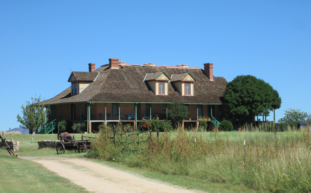
The home site is situated on a knoll with vistas of the Sonoran Desert to the south and rolling hills in every other direction. It includes the main house, a large barn, an adjacent livestock barn, corrals, and a blacksmith/machine shop. Before 1884, the site was occupied only by a small adobe dwelling. Between 1885 and 1900, however, Colin built three other adobe dwellings and numerous outbuildings there, along with a two-story Territorial Style ranch house (circa 1890). Most of these were destroyed by fire in December 1899 (the charred ruins were fully demolished by the early 1900s). Colin then built the present ranch house: a 5,000-square-foot rectangular building with a concrete, partially raised basement and two upper stories. Designed in a French Colonial Revival style, the ranch house’s most distinctive features are the full, wraparound veranda at the main level and the shingled hipped roof. Six paired dormers along the hipped roof allow natural light into the upper story, while four brick chimney stacks with double cornices allude to the five fireplaces on the main level. The high-ceilinged rooms, finished in plaster, feature fir-wood floors and picture molding.
The brick edifice used locally quarried materials, but the masons, laborers, and carpenters were brought to the ranch. No expense was spared on the California redwood doors, molding, shingles, and baseboard trim. In fact, an edition of the Arizona Republican in late 1900 claimed it was “the finest ranch house ever seen on a cattle ranch.” Most early Arizona ranchers built adobe houses that featured Spanish Colonial/Sonoran vernacular stylistic features, in keeping with the region’s architectural patrimony, although they employed American building forms and contemporary construction techniques. Indeed, Colin’s choice of a French Colonial Revival style—more often associated with the antebellum, bayou plantations of Louisiana or the tropic climes of the West Indies—was unique to the region. Proximity to the California-based Southern Pacific Railroad ensured that new building materials were readily available, thereby encouraging homeowners to experiment with other American styles over the local vernacular.
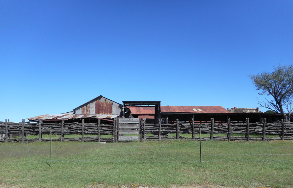
All of the ranch’s outbuildings have either concrete or rock-and-concrete foundations, concrete floors, brick and/or adobe brick walls, and wood-frame roofs sheathed in corrugated sheet metal. The circa 1895 main barn, which survived the 1899 fire, is the oldest unaltered building on the site. Its rectangular footprint, measuring 501 feet by 50 feet, includes tack and storage rooms as well as a hayloft. The adjacent, 50 x 24–foot livestock barn, originally built to house Shetland ponies, also predates the fire, but it was greatly modified in the second quarter of the twentieth century. The industrial blacksmith shop, 60 feet by 24 feet, was built in 1900. An interior wall divides the space into a smithy (forge) and a workroom, both fitted with back-to-back fireplaces.
Miner and cattleman Colonel William Cornell Greene, who resided in Cananea, Mexico, purchased the ranch in 1903 and owned it until his death in 1911. He bequeathed it to his family, the Sharps, who managed the working ranch until 1998. As the profitability of large-scale industrial cattle ranching began to wane in the mid-1950s, the Sharps turned to other sources of revenue. Along with neighboring ranches, the San Rafael Ranch became the backdrop for Hollywood films: westerns such as Oklahoma! (1955), McLintock! (1963), and Mr. Horn (1979) were shot there. In 1998, Arizona State Parks purchased 3,557 acres of the lower section, including the home site, for public use; at the same time, the state agency placed a conservation easement on the remaining 17,574 acres so that the landscape will be preserved while buffer tracts are sold for ranching pursuits.
References
Eatherly, Charles R. “History of San Rafael State Natural Area.” Arizona State Parks. Accessed December 13, 2015. http://azstateparks.com/.
Freisinger, Michael A., “San Rafael Ranch Historic District,” Santa Cruz County, Arizona. National Register of Historic Places Registration Form, 2007. National Park Service, U.S. Department of the Interior, Washington, D.C.
Hilliard, Josephine Antoinette, and Matthew Sterner. “Cattle Ranching and Ranch Architecture in Southern Arizona.” In Cross-Cultural Vernacular Landscapes in Arizona. Edited by Laura H. Hollengreen and R. Brooks Jeffery. Tucson: Vernacular Architecture Forum, 2005.