

The Wall
You are here
United States–Mexico Border


1994–2009. Pacific Ocean to the Gulf of Mexico.
A “well designed fence along the U.S. side…[would] eliminate entire classes of the present illegal crossers, such as the small shoe shine boys and other juvenile urchins, women, family groups with women and small children,” speculated U.S. Border Patrolman David Snow in a 1953 memo. Over thirty years later, critic Gloria Anzaldúa, who grew up along the Texas–Mexico border and subsequently moved to California, characterized such a structure as metaphorically “staking rods in my flesh.” Fencing along the U.S.–Mexico border has been as much a symbol for social and political policy as it was an architecture project. Nevertheless, architecture proved instrumental to institutionalizing the border as an effective barrier between the peoples of Mexico and the United States. Historically, there had persisted since conquest “borderlands” classes of people, ethnically neither entirely Mexican nor American. Snow dismisses them as a small number of marginalized figures who added little to the economy and likely threatened only to drain resources from U.S. federal and local governments. Fencing the border would push these people to pick a side. Though others would continue to approach the border, these migrant laborers would be restricted to a single crossing northward into the United States, into a country from which they might never dare return. In the process, transnational subjects like those Anzaldúa studied and theorized would find their futures imperiled.
Prior to World War II, the U.S.–Mexico border was largely unfenced. Architects and designers were rarely called upon to demarcate this line, which was far more visible on maps than in the physical landscape. Small stone piles appeared along roadways. Such structures served less to discourage cross-border travel than simply to remind migrants and tourists they had entered a new country and to teach them the history and significance of their journey. Borderlands Indians, construction workers, and even some ranching and mining entrepreneurs destroyed some of these markers. By the turn of the twentieth century, a more sturdy line of 276 monojeras or monuments dotted the borderline. The development of the border into a more intensive barrier began in the postwar years. The first significant installation at Calexico required an enormous, 4,500-foot bundle of chain link fencing the federal government repurposed from a Japanese internment camp in Crystal City, California. This fence spanned roughly six miles in either direction. The idea was to push undocumented crossers as far as possible into the inhospitable deserts to the east and west before crossing. A simple pair of wire cutters was all a crosser needed to get through, so the U.S. Border Patrol also lobbied for funding to build watch towers. Materials that began as part of an operation to contain an ethnic minority within camps during the war graduated into a much more ambitious effort to contain an entire nation outside the country’s newly significant boundaries.
In the 1990s, a changed political climate provoked the first shift from fencing to building a wall along the border. Critical geographer Michael Dear illustrates how permeable the border had remained, especially in the imaginations of architects and urban planners. Kevin Lynch and Donald Appleyard produced a 1974 report for the City of San Diego in which they called for the American city to join Tijuana as part of a “unified metropolis.” At the turn of the millennium, hopes for such a transnational space were dashed. The first materials for this new wall were metal plates from Vietnam-era temporary aircraft landing strips. As of 2006, the U.S. Secure Fence Act provided new allocations to make the border into the largest domestic building project of the new millennium. Fortifications would cost $16,000,000 per mile. All those miles of fencing between San Diego and Yuma, Arizona, were completed by January 2009.
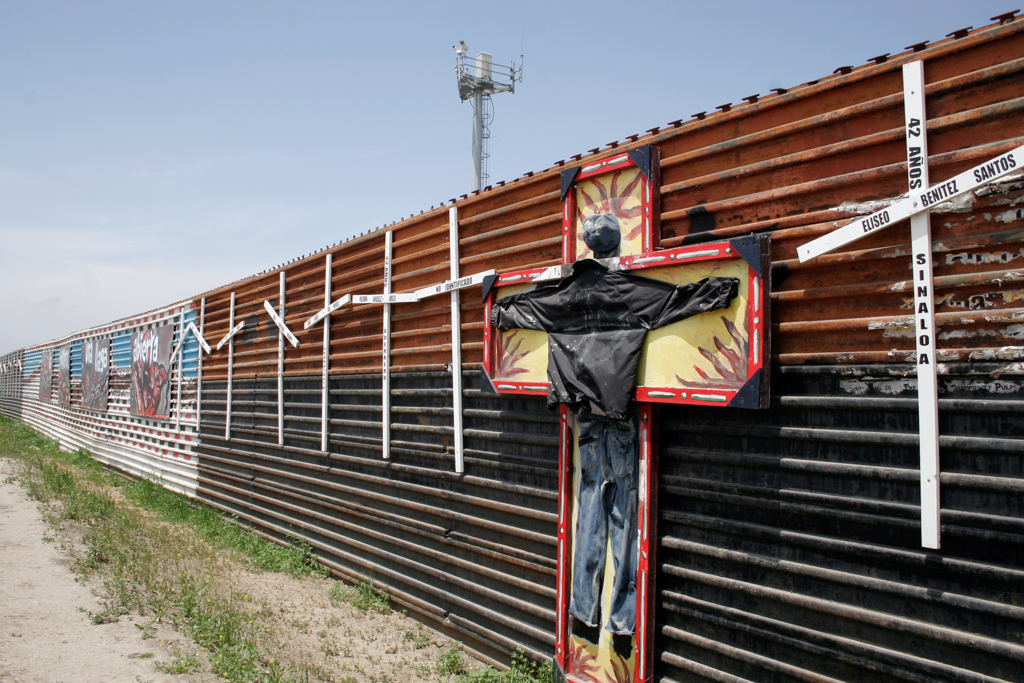
Beyond architecture, the border fence today is much more than a wall; it also includes landscaping. To block Smuggler’s Gulch near Tijuana, Border Patrol engineers dumped 1.6 million cubic yards of landfill. All that remains of this seasonal water course is underground piping. The “virtual fence” also includes extensive surveillance equipment. Heat sensors, video cameras, and Border Patrol agents driving SUVs and ATVs supplement the wall’s built form. Between 1994 and 2009, these activities produced a radically transformed ecology and the deaths of more than six thousand crossers who attempted entry into the United States without documentation.
In recent years, Berkeley architect Ronald Rael has proposed innovations for a new vision of the U.S.–Mexico border. Social infrastructure along the fence might include binational parks where residents of neighboring communities could gather together to learn yoga or to play volleyball using the 21-foot-tall and 6-foot-deep rusted steel barrier as a net. Forty thousand acres of U.S. land now lying between the fence and the official territorial border has the potential to house solar farms. These ideas prove that architects have great power to design symbols of integration into the borderlands. On a more vernacular level, graffiti artists began a similar process. While the fence is stark and blank on the northern side, Mexican artists have left mementos and marked up the fence’s southern face with images and letters. This contrast between stark bureaucracy and folk expressiveness has sometimes evoked comparisons with the East and West sides of the Berlin Wall. During the presidential election of 2016, then candidate Donald Trump made the extension of the wall a focus of his campaign rhetoric. As president, he has renewed these calls.
References
Adelman, Jeremy and Stephen Aron. “From Borderlands to Borders: Empires, Nation-States, and the Peoples in between in North American History. American Historical Review 104 (June 1999): 814-841.
Anzaldúa, Gloria. Borderlands/La Frontera: The New Mestiza. San Francisco: Aunt Lute Books, 1987.
Dear, Michael. Why Walls Won’t Work: Repairing the U.S.-Mexico Divide. New York: Oxford University Press, 2013.
Lytle Hernández, Kelly. Migra!: A History of the U.S. Border Patrol. Los Angeles: University of California Press, 2010.
Rael, Ronald. “Boundary Line Infrastructure.” Thresholds 40 (2012): 75-82.
Writing Credits
Coordinator:
Emily Bills
If SAH Archipedia has been useful to you, please consider supporting it.
SAH Archipedia tells the story of the United States through its buildings, landscapes, and cities. This freely available resource empowers the public with authoritative knowledge that deepens their understanding and appreciation of the built environment. But the Society of Architectural Historians, which created SAH Archipedia with University of Virginia Press, needs your support to maintain the high-caliber research, writing, photography, cartography, editing, design, and programming that make SAH Archipedia a trusted online resource available to all who value the history of place, heritage tourism, and learning.