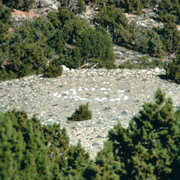
The 30-mile-wide, 8,000-foot-high North Park valley provides a magnificent setting for fourteen stone circles on the southwest side of the road. The circles are grouped along the crest of an open, grassy ridge a quarter mile northeast of Placer Creek. The windy, south-facing site provided good visual scouting, as well as relief from summer insects and winter snow. The stones were probably ritualistic rather than functional, as no known painting or photograph of early tipis shows stones sealing their bottom edges. The stone circles, some with a stone-lined firepit in the center, measure about ten to fifteen feet in diameter. No doubt these stones have been rearranged by visitors and archaeologists, but they remain a magical remnant and are among the best and oldest building footprints left by the Ute Indians.
You are here
Placer Creek Tipi Ring Site
6 miles west of Cowdrey on Jackson County 6W, then 2.3 miles north on Jackson County 3 (Independence Mountain Rd.)
If SAH Archipedia has been useful to you, please consider supporting it.
SAH Archipedia tells the story of the United States through its buildings, landscapes, and cities. This freely available resource empowers the public with authoritative knowledge that deepens their understanding and appreciation of the built environment. But the Society of Architectural Historians, which created SAH Archipedia with University of Virginia Press, needs your support to maintain the high-caliber research, writing, photography, cartography, editing, design, and programming that make SAH Archipedia a trusted online resource available to all who value the history of place, heritage tourism, and learning.

