


Eagle Point Park consists of over 175 acres overlooking the Mississippi River and Lock and Dam No. 11 in the northeast corner of Dubuque, near the borders of Wisconsin and Illinois. In 1907 city planner Charles Mulford Robinson selected the clifftop site to establish a park, one that would offer a stunning view of Iowa, Illinois, and Wisconsin, as well as the Mississippi River 250 feet below.
Robinson and landscape architect Charles N. Lowrie laid out the park, which included a system of roads and walkways. Over the next several decades, the city funded other improvements such as shelters and tennis courts. The Union Electric Company established streetcar service in 1912, constructing the track, turnaround, and waiting station near the park entrance where the eagle statue and flower beds now stand. The construction of Lock and Dam No. 11 in 1937 ultimately changed the scenic views, with the water quickly swallowing a bathing beach that had opened in 1920 and Kimball's Park, an island in the middle of the river that hosted summer cottages.
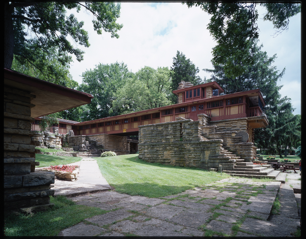
The most significant work was completed during the New Deal era. With the help of Works Progress Administration funding, the City of Dubuque hired Alfred Caldwell to serve as superintendent beginning in 1934. During his two-year tenure, the project employed 200 workers who cleared trails, established naturalistic gardens, quarried local stone, harvested timber, and constructed pavilions in the Prairie Style. The focal point of this effort was a large stone complex located approximately in the center of the park, which historians have compared to Wright’s Taliesin at Spring Green, Wisconsin. Caldwell referred to these buildings, which included picnic shelters and pavilions intended for year-round use, as the “City in a Garden.” Integrated into the landscape through the artful manipulation of native limestone and a strong horizontal orientation, Caldwell’s buildings represent a mastery of organic architecture. Caldwell personally trained the workers in laying long but thin pieces of rough-cut limestone to simulate the face of a rock cliff. The buildings that make up this complex are further tied together by naturalistic landscaping, low stone walls, and stone paving. Of particular note is the Bridge Complex, a cruciform-shaped building with an enclosed bridge spanning the east and west portions and a multi-storied Lookout Tower on the west end. Caldwell also built a series of his signature council rings located on the edge of the park overlooking the river and the lock and dam system.
The architectural firm of Paul Rossiter and Vernon Hamm designed an open-air pavilion just south of the Bridge Complex in the 1950s, and the park became a popular place for Dubuquers to meet for family events, bird and river watching, walking, and concerts, among other activities. It also became a late-night hangout, and by the late 1970s the city focused its efforts on controlling rowdiness and vandalism by banning alcohol, closing the park earlier, and imposing a nominal use fee. In 1985, the city lowered the road under the Bridge Complex to accommodate bus traffic, and also began offering carriage rides. In 2010 the original trolley line from Shiras Avenue to the turnaround was converted to a biking and walking path. The park continues to be one of the city’s grandest assets. In 2019, an 11.5-acre land donation in honor of Dubuque native Wayne Anthony expanded the park to its current size.
References
Domer, Dennis, ed. Alfred Caldwell: The Life and Work of a Prairie School Landscape Architect. Baltimore: Johns Hopkins University Press, 1997.
“2019 Land Donation in Honor of Wayne Anthony.” City of Dubuque. Accessed February 10, 2021. https://www.cityofdubuque.org/.
Piper, Andy. “About Eagle Point Park.” Telegraph Herald (Dubuque, IA), July 26, 2009.
Schlarman, Julie, “Eagle Point Park Historic District,” Dubuque, Iowa. National Register of Historic Places Registration Form, 2017. National Park Service, U.S. Department of the Interior, Washington, D.C.