


The Bonnet Carré Spillway protects New Orleans from Mississippi River floods by providing a passage for excess river floodwaters to discharge into Lake Pontchartrain and thence to the Gulf of Mexico. The spillway is one of the flood-control structures along the Lower Mississippi authorized by the Flood Control Act of 1928 and built by the U.S. Army Corps of Engineers. The act was a response to the floods of 1927 that devastated the Mississippi valley, as eloquently described by John M. Barry in his Rising Tide: The Great Mississippi Flood of 1927 and How it Changed America (1997). Other flood control structures in Louisiana include the Morganza Spillway (begun 1929) upriver from the Bonnet Carré in Point Coupée Parish and Old River Control (begun 1951) on the border of Point Coupée and the state of Mississippi.
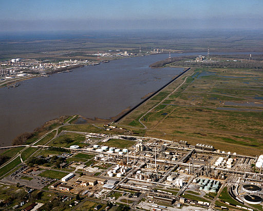
This site for the Bonnet Carré’s dam and spillway was selected because four major crevasses had occurred here since 1849, indicating that it was a weak point in the Mississippi River’s levee system. The dam consists of 350 bays, each 20 feet wide, set between reinforced concrete piers and closed by vertical timbers that can be raised as needed. The bays can be opened singly or in combination. Earthen guide-levees that contain the water within the spillway are spaced 7,700 feet apart at the river, gradually widening to 12,400 feet at Lake Pontchartrain for a total length of 5.7 miles. The vast width of this spillway illustrates the force and power of the Mississippi River, and dramatizes the fact that the river is higher than the spillway. The spillway was first opened in 1937 and has been opened eleven times since then, the last being in 2011. Railroad and highway (U.S. 61) crossings on the lake side of the dam were completed in 1936 and now I-10 runs along the southwestern boundary of the lake.
The spillway has become a recreation area (when not inundated), graced by wildlife and native plants and popular for fishing, biking, camping, and model airplane flying competitions. On the downriver side of the dam and spillway is the Shell Chemical Company, which began manufacturing chemicals and feedstock operations here in 1955. At sunset the vista from the top of the levee that separates the spillway from the chemical plant is spectacular. Downriver is the glistening industrial complex, with its twinkling lights and continuous low humming sound; across the river the towers and pipes of other chemical plants spike the sky; upriver the red sky blazes over the spillway's broad, flat expanse of grass, and the Mississippi's gleaming sunset-tinted surface is broken only by huge silent ships at anchor or moving slowly along its expanse.