You are here
Sleeping Bear Dunes National Lakeshore
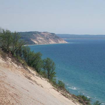
Lying on the northeastern shore of Michigan’s lower peninsula, or “little finger,” Sleeping Bear Dunes National Lakeshore comprises 65 miles of the Lake Michigan shoreline and contains the largest collection of freshwater sand dunes in the world. The park has enormous dunes and moraines, many towering 400 feet above lake level, as well as numerous inland lakes and streams, and an exemplary display of glacial land formations. Sleeping Bear Dunes is a showcase for the natural grandeur of the Great Lakes, in all its topographic and ecological diversity, which is all the more remarkable given that the Great Lakes’ national reputation is predicated on industry and shipping.
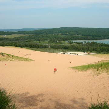
The Sleeping Bear Plateau is five miles long and three miles wide, made of steep, shifting sand dunes and high bluffs that offer impressive vistas. The dune system plays an important role in beach formation along the eastern Lake Michigan shoreline, as eroded sands are transported great distance by strong lake currents. The ecology of the area is diverse and contains plant communities unique to Michigan. Wetlands, bogs, and multiple conifer and hardwood forest types grow throughout the park, but it is the sand dune ecosystem that takes center stage. Sleeping Bear Plateau’s dunes present an opportunity to experience an ecology rarely found in the Midwestern United States. The sand dunes of Michigan are historically important as the early-twentieth-century birthplace of Henry Chandler’s concepts of succession and “dynamic ecology.” In the twenty-first century, numerous ecological studies research the park’s diverse ecosystems.
Human settlement in the area dates back to 3000 BCE, with more recent inhabitation by the Ottawa and Chippewa tribes in the seventeenth century. The area was thus rich in Native American history, stories, and meaning, long before the arrival of Europeans, who contributed their own rich history of arrival, settlement, and usage, including shipping, lumbering, and agriculture, especially fruit orchards. The park contains a publically accessible historic lighthouse on Manitou Island, an extensive historic rural farm and orchard district, early stations of the U.S. Coast Guard (formerly the Life-Saving Service), and well-preserved towns and villages that supplied fuel wood to the many steamships that passed by the area.
Sleeping Bear Dunes takes its name from a Chippewa legend. According to the story, a mother bear and her two cubs were driven from the Wisconsin shoreline by a forest fire. As the mother made it to the other shore in Michigan, she climbed the dune to watch for her two cubs, who were lagging behind and drowned just before reaching land as a result of exhaustion. The Great Spirit Manitou created two islands (North Manitou and South Manitou islands) to memorialize the cubs, and a great sand dune to honor the watchful mother bear.
The establishment of Sleeping Bear Dunes National Lakeshore was a significant moment in the conservation history of the national parks. Initially, the recreational area did not include any significant portion of the shores of the inland lake, since these lands were in private hands and well-suited for the development of housing and other recreational amenities. Landscape architect E. Genevieve Gillette was the person most responsible for changing attitudes and eventually expanded the park to include these lakeshore lands. Along with her mentor Jens Jenson, Gillette was a leader in conservation in Michigan; she worked closely with P.J. Hoffmaster, the first director of Michigan’s state park system, to establish public preserves and recreation areas and, together, they created a robust and far-reaching plan for the Michigan state park system. In 1959, Gillette established the Michigan Parks Association to bring naturalists and scientists together with those advocating for more recreation and tourism, with the express purpose of building a more cohesive and powerful constituency for the state parks. The establishment of the National Lakeshore set an important precedent for the conservation of other natural landscapes.
Drawing on this work as she addressed plans for Sleeping Bear Dunes, Gillette argued for extending the park to include the dunes and lakeshore. She developed a geological argument about the Platte River area that emphasized how the geology of the land shaped the topography of the region, including Platte River, Platte Lake, and Platte Plains. In this way, she argued that the entire 77,000-acre site (as opposed to the original 26,000 acres) should be designated a park. The Sleeping Bear National Lakeshore was established as a national park on October 21, 1970, and in 2014 a section of the park was designated as a national wilderness, entitling the park to the highest level of federal protection. Over the years, hiking paths, access routes to the lake, and other recreational amenities have been added, although there strict regulations concerning impact on the natural environment remain in place. Today, the park balances stewardship of a natural landscape with public recreational opportunities, including swimming, hiking, and a popular dune climb.
References
Kaufman, P. W. National Parks and the Woman’s Voice: A History. Albuquerque: University of New Mexico Press, 1996.
Gillette, E. Genevieve, Miriam Rutz, Gladys May Beckwith, and Gwen Frostic. Miss E. Genevieve Gillette, Landscape Architect: A Memorial Volume, 1898–1986. [Lansing?]: Michigan Women’s Studies Association, 1986.
Rutz, Miriam Easton, and Kristi Rutz Robbins. Emma Genevieve Gillette: Nature's Guardian Angel. Fort Collins, CO: Cottonwood Press, 1994.
Tishler, W. H. Midwestern Landscape Architecture. Urbana: University of Illinois Press, 2000.
National Park Service. “Sleeping Bear Dunes.” Accessed July 15, 2015. www.nps.gov.
Sleeping Bear Dunes Visitors Bureau. “Area History.” Accessed July 15, 2015. www.nps.gov.
Writing Credits
If SAH Archipedia has been useful to you, please consider supporting it.
SAH Archipedia tells the story of the United States through its buildings, landscapes, and cities. This freely available resource empowers the public with authoritative knowledge that deepens their understanding and appreciation of the built environment. But the Society of Architectural Historians, which created SAH Archipedia with University of Virginia Press, needs your support to maintain the high-caliber research, writing, photography, cartography, editing, design, and programming that make SAH Archipedia a trusted online resource available to all who value the history of place, heritage tourism, and learning.


