


The Blue Ridge Parkway is one of the most popular scenic drives in the National Park System. It stretches 469 miles connecting Shenandoah National Park in Virginia to the Great Smoky Mountains National Park in North Carolina. The picturesque parkway conserves the natural landscape of Southern Appalachia and has provided recreational opportunities for generations of Americans.
Planning for the parkway began as early as 1909, with suggestions from Colonel Joseph Hyde Pratt for a scenic “Crest of the Blue Ridge Highway.” In 1933, a proposal for what would become the Blue Ridge Parkway was approved as part of the Industrial Recovery Act. Negotiations on routes and the acquiring of land through eminent domain delayed the start of construction on this emergency works project to September 11, 1935. Construction continued for the next 50 years, with work beginning on each section only once all land along the route had been purchased or acquired and contractors could be found to perform the work.
The Blue Ridge Parkway has several well-known stops along its length, including overlooks, picnic areas, and campsites. The parkway is both a cultural and environmental landscape that winds its way through mountainous terrain to bring travelers close to important heritage sites such as the Western North Carolina Nature Center (near milepost 382), the North Carolina Arboretum (milepost 393), Oconaluftee Indian Village (just beyond the western terminus of the parkway), Linville Caverns (near milepost 317), and Grandfather Mountain (near milepost 305). Several stops provide interpretive centers for regional music, crafts, and agriculture. The Blue Ridge Music Center (near milepost 213) and the Folk Art Center (near milepost 382) give visitors an introduction to indigenous art forms. During autumn, when the leaves change colors, the parkway is especially popular. Panoramic vistas can be viewed from a number of overlooks—over 200 in all. The pull-offs at Craggy Dome (milepost 364) and Graveyard Fields (milepost 418.8) offer spectacular views of terrain and flora below, and the highest point of the parkway at Richland Balsam (milepost 431) offers a vantage from 6,053 feet above sea level.
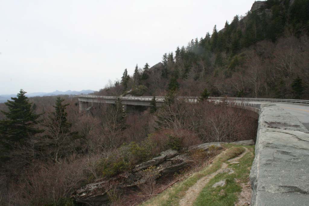
The final section or “missing link” of the parkway was the Linn Cove Viaduct. This 7.7-mile floating bridge around Grandfather Mountain did not begin construction until 1979 and was completed in 1983. The delay in construction was originally caused by right-of-way disputes between the National Park Service and the owner of Grandfather Mountain, which were finally settled in 1968. The next decade was spent performing geological surveys, testing roadway alignments, and assessing impact to the natural slope of Grandfather Mountain. Designed by Jean Muller, the viaduct was a technological feat of highway engineering and landscape conservation. The first segmental precast concrete structure at the time to follow the contour of surrounding topography, the viaduct was also built progressively, with one segment driven over the cantilevered previous piece and lowered into place.
The parkway opened for through traffic in 1987 and it remains a popular scenic byway.
References
“Blue Ridge Parkway (U.S. National Park Service).” National Parks Service. Accessed January 28, 2019. http://www.nps.gov/.
“Blue Ridge Parkway, Linn Cove Viaduct,” North Carolina. Historic American Engineering Record, 1997. Prints and Photographs Division, Library of Congress (HAER No. NC-42 A).
Harley, Jolley. The Blue Ridge Parkway. Knoxville: University of Tennessee Press, 1969.
Ireland, Robert E., and Marcus B. Simpson Jr. “Blue Ridge Parkway.” NCpedia. Accessed January 28, 2019. http://www.ncpedia.org/.
Mitchell, Monte. “25-year-old Linn Cove Viaduct floats around Grandfather Mountain.” Winston-Salem Journal, September 11, 2012.
North Carolina Office of Archives & History - Department of Cultural Resources. “Marker: M-49.” North Carolina Highway Historical Marker Program. Accessed January 28, 2019. http://www.ncmarkers.com/.
Osmet, Timothy. “The Blue Ridge Parkway.” Learn NC, The University of North Carolina at Chapel Hill. Accessed January 28, 2019. http://www.learnnc.org/.
“Timeline of Blue Ridge Parkway Construction.” Documenting the American South. Accessed January 28, 2019. https://docsouth.unc.edu/.
Vance, Renné.”Linn Cove Viaduct.” NCpedia. Accessed January 28, 2019. http://www.ncpedia.org/.
Visual Character of the Blue Ridge Parkway, Virginia and North Carolina. Washington, D.C.: U.S. Dept. of the Interior, National Park Service, 1997.
Whisnant, Anne Mitchell, and David E. Whisnant. When the Parkway Came. Chapel Hill, N.C.: Primary Source Publishers, 2010.