

Cape Hatteras Light Station
You are here
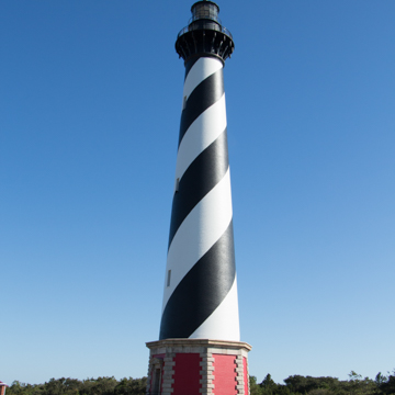
Cape Hatteras Lighthouse
1868–1870, Dexter Stetson. 46379 Lighthouse Rd.
-
 (David Koontz)
 -
(Photograph by David Koontz)
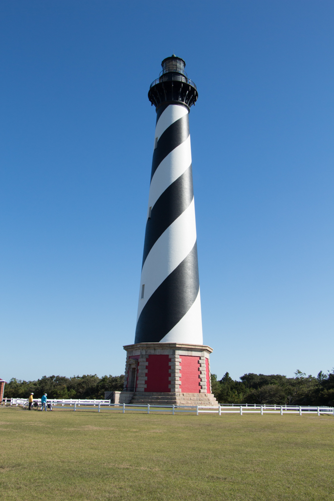
Cape Hatteras Lighthouse overlooks Diamond Shoals, historically one of the most dangerous areas of the so-called Graveyard of the Atlantic. The tallest brick lighthouse in the United States, its black and white spiral marking makes it one of the most iconic buildings on the Outer Banks of North Carolina.
The lighthouse was positioned not at a major port, but at a point of heavy shipping traffic. The Labrador Current moves south along the coast and the Gulf Stream, only twelve miles further out to sea, moves in the opposite direction creating a coastal highway. The two currents assisted travel up and down the coast, and often sailing ships tacked back and forth just north of Cape Hatteras waiting for favorable winds. The waters were dangerous, however, as the shifting currents constantly reshaped underwater dunes that lie just under the surface and can be up to 250 feet tall. The shoals, currents, and the absence of natural landmarks made the waters along Cape Hatteras one of the most treacherous sailing routes of the Outer Banks.
When Alexander Hamilton became a member of George Washington’s cabinet, he recalled a nearly tragic incident he experienced as a young man aboard the sloop Thunderbolt, off the shore of Cape Hatteras, and prodded the first Congress to pass the Lighthouse Bill in 1789. This set in motion the establishment of several lighthouses along the east coast. Construction of the first lighthouse at Cape Hatteras began in September 1799 and was completed in late 1802. The tower was made of granite, sandstone, and iron. It was an octagonal pyramid reaching 90 feet with a 10-foot-tall lantern room on top. A wooden spiral stair provided access to the 18 oil lamps fueled by the whale oil housed in cedar cisterns.
In 1823, French physicist Augustin Fresnel changed the lighthouse technology with his system of prisms and lenses that concentrated the light produced by a flame. His lenses rotated around a single lamp. They were produced in seven sizes called orders, with the first order being the largest. In 1854, the first Hatteras lighthouse was increased in height to 150 feet and given a first-order Fresnel lens. Also built in 1854 was the double keeper’s quarters.
By the end of the Civil War, the first lighthouse had deteriorated sufficiently to prompt Congress to authorize $75,000 to begin construction of a replacement. Dexter Stetson was hired as foreman and construction commenced in December 1868. The new site, 600 feet north of the old tower, was 1,600 feet from the high tide mark. The foundation was laid on a compacted sand base, with yellow pine timbers laid in a grid and reinforced with rubble masonry and granite. Scows brought 1,250,000 bricks from kilns along the James River. In November 1869 the brick and granite base above the foundation was completed. The majority of construction was finished in 1870 and a first-order Fresnel lens was installed. From base to top, the brick tower was 196 feet and the iron superstructure added another 12 feet. The total cost was $155,000. Along with the lighthouse, new living quarters were built for the principal keeper and his family, with the double keeper’s quarters now housing two assistants. The remains of the old tower were dynamited in 1871 and local islanders collected the rubble to use for chimneys and walls.
In 1873, the tower was painted with the iconic black and white spiral daymark. At night, the Fresnel lens rotated at a speed maintained by the governor to produce a frequency of a 1.4 second flash to a 4.6 second eclipse that was specific to Hatteras and recognizable at night. The rotation was powered by weights suspended in the center of the tower. Cranking the weights back to the top was among the lighthouse keeper’s many responsibilities. The first light was a mantle lamp fueled by kerosene. In 1912, the lamp was replaced with an incandescent oil-vapor lamp. This increased the intensity of the lamp from 27,000 to 80,000 candlepower. In 1934, two Kohler generators and a large bank of batteries were placed in the building that had previously stored oil supplies.
As early as 1919, there were concerns about waves hitting the lighthouse base, but efforts to stop their advancement proved ineffective. Waves finally reached the base of the lighthouse in 1936, forcing its closure on May 15. Three years later, the U.S. Coast Guard took over lighthouse operations. A decade later, in December 1948, the National Park Service took over title of the lighthouse but the Coast Guard, granted a use-lease for twenty years, continued to operate it. The tower was repaired and electrical wiring installed. By then, the original lamp and Fresnel lens were in disrepair; they were soon replaced with an electric beacon with a 1,400-watt bulb. By January 23, 1950 the lighthouse was restored to full operation. The new lamp was 250,000 candlepower and could be seen for 20 miles. Its rotation was controlled by a timer and switched on by a photoelectric cell.
The encroaching sea continued to threaten the tower, and in 1969 the Navy built three groins of reinforced concrete almost directly in front of the existing base in an effort to halt the advancing waves. This prompted a lengthy debate about whether an octagonal seawall should be built around the lighthouse, which would, in effect, form an island, or whether the lighthouse itself should be moved away from the shore. The original plans revealed that the center of gravity of the approximately 4,400-ton landmark was located only a third of the way up from the base, making relocation feasible. In 1989 the National Park Service finally decided that the lighthouse had to be moved. In a huge preservation effort, the lighthouse and its supporting buildings were moved along rails, rollers, and dollies to a new site 2,900 feet southwest of the original. The process began on Thursday, June 17, 1999 and the lighthouse reached its destination on July 9, 1999. The brick oil house, keeper’s houses and cisterns were also moved to the new site to positions that replicated their original locations relative the lighthouse. The tower was opened to the public in April 2003.
Today, the Cape Hatteras Lighthouse is reached by a path in a large open area. The base looks much like it did when it was first built. It measures 24 feet high and 45 feet 6 inches in diameter at the lower plinth course. Granite quarried in Vermont was used in the steps, foundation, and trim. Above the base is the double brick wall tower with the outer wall shaped as a truncated cone and the inner wall as a cylinder containing the central open shaft 11.5 feet in diameter. Radial brick walls connect the two like spokes on a wheel. Within the shaft, the spiral metal stairway has 268 steps that wind from landing to landing; 9 flights connect landings on opposite sides of the tower with windows at each. Rails that once guided weights down the center of the tower are still extant. The shaft has a total of 7 windows with stone lintels and sills. At the top of the tower, iron brackets support the gallery deck and balustrade. A second catwalk encircles the lantern. At the peak of the copper roof is a metal spike atop a spherical finial. The view from the balcony stretches out beyond Diamond Shoals and the original lighthouse location. From here, it is clear the preservation efforts have saved a remarkable landmark.
The lighthouse has scheduled visiting hours when it is open for climbing.
References
Bishir, Catherine W. and Michael T. Southern. A Guide to the Historic Architecture of Eastern North Carolina. Chapel Hill: University of North Carolina Press, 1996.
Carr, Dawson. The Cape Hatteras Lighthouse: Sentinel of the Shoals. Chapel Hill: University of North Carolina Press, 2000.
McNaughton, Marimar. Outer Banks Architecture: An Anthology of Outposts, Lodges, & Cottages. Winston-Salem, NC: John F. Blair Publisher, 2000.
Roberts, Bruce and Cheryl Shelton-Roberts. North Carolina Lighthouses: Stories of History and Hope. Lighthouse Series. Guilford, CT: Globe Pequot, 2011.
Warfield, Ronald G. “Cape Hatteras Light Station,” Dare County, North Carolina. National Register of Historic Places Inventory–Nomination Form, 1977. National Park Service, U.S. Department of the Interior, Washington, D.C.
Writing Credits
Coordinator:
Kristen Schaffer
David Hill
If SAH Archipedia has been useful to you, please consider supporting it.
SAH Archipedia tells the story of the United States through its buildings, landscapes, and cities. This freely available resource empowers the public with authoritative knowledge that deepens their understanding and appreciation of the built environment. But the Society of Architectural Historians, which created SAH Archipedia with University of Virginia Press, needs your support to maintain the high-caliber research, writing, photography, cartography, editing, design, and programming that make SAH Archipedia a trusted online resource available to all who value the history of place, heritage tourism, and learning.