


The five-mile stretch of U.S. Route 66 that runs through Tucumcari is a unique example of a commercial strip developed in response to the rise of automobile tourism between 1926 and 1956. Once a railroad town positioned between Amarillo and Albuquerque along the Ozark Trail, Tucumcari emerged as one of New Mexico’s main automobile-oriented thoroughfares following the Federal Highway Act of 1926, when New Mexico’s main east-west transportation networks were realigned to become part of Route 66 from Chicago to Los Angeles. Unlike much of the commercial development along this highway in New Mexico, which followed earlier railway networks, the Tucumcari stretch of Route 66 was constructed several blocks south of the tracks and was shaped entirely by the automobile.
Before the Federal Aid Highway Acts of 1916 and 1921 provided federal funding for the creation of state highways and led to the establishment of a national system in 1926, at least four private highways ran through Tucumcari. In 1933, with federal funding, these four separate highways were raised, paved, joined and realigned to become part of Route 66. With improved highways and increased ownership of cars, automobile tourism supplanted railroad travel throughout New Mexico and across the country. In response, commercial development increasingly catered to motorists. Tucumcari’s railroad-era commercial development had centered on Gaynell Avenue, the town’s original main street located alongside the tracks several blocks to the north. The inconvenience for motorists, who now had to detour off the highway in search of stores, lodging, service stations, and restaurants, led to the creation of a new main street along Route 66 in the 1930s.
The speed of automobile travel gave rise to the pervasive use of neon signs to catch the eye of passing motorists. Invented by the Frenchman George Claude and brought to the U.S. in 1923, neon signage would shape the cultural landscape of Route 66 as it became the defining feature of most commercial structures built from the 1930s to the 1960s. The commercial highway also gave rise to such new building types as service stations, curio shops, and motels.
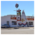
Combined service stations and curio shops sprang up when businessmen recognized a new market in local curiosities and souvenirs for motorists making a quick stop while passing through town. Tee Pee Curios began in 1944 as a Gulf gas station, grocery store, and souvenir shop. When Route 66 was expanded from a two-lane road to a four-lane highway after World War II, many business owners installed new roadside signs and altered and expanded their facades to attract the attention of motorists amidst more traffic and higher speeds. In 1959, the Tee Pee’s gas pumps were removed and its trademark stuccoed and painted teepee was added. The colorful neon sign, added in the mid-1960s (restored in 2003), is mounted by brackets to a tall steel post that projects several feet beyond the shop’s entrance and markets a whimsical roadside image of the Southwest.
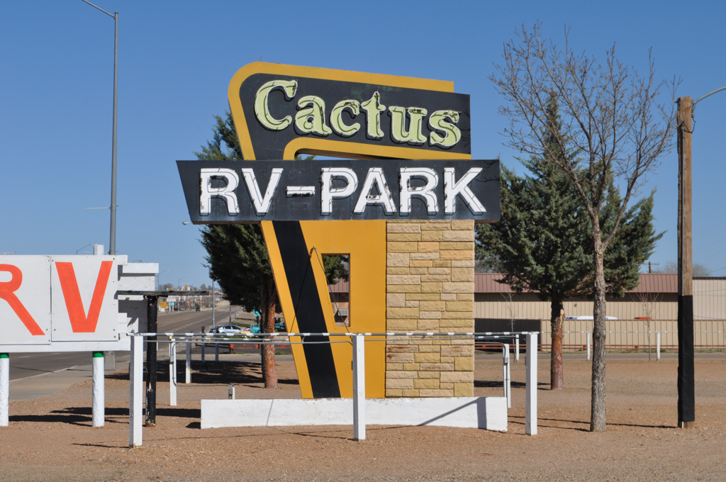
Motels and motor lodges expanded upon the popular tourist court with better amenities and more modern accommodations. The Cactus Motor Lodge (now the Cactus RV Park), built by I.E. and Edna Perry in 1941, accommodated automobile tourists with rooms, convenient parking, and recreational facilities. The U-shaped complex had 25 units with attached, enclosed garage bays, organized around a central court that once held a landscaped park and playground; a pool was added in the 1950s (and later filled in). Built with hollow clay tile and concrete, the Cactus Motor Lodge originally marketed itself as iconically Southwestern with the typical tan stucco and projecting vigas of the Pueblo Revival; this was altered in 1952 with the installation of artificial Perma-stone on the exteriors. A large, freestanding neon sign built in the 1950s announced “Cactus Motor Lodge / It Just Looks Expensive,” with large, neon-framed block letters that were easily read from the highway.
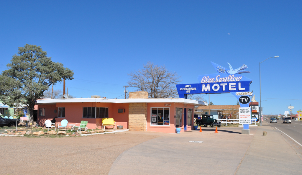
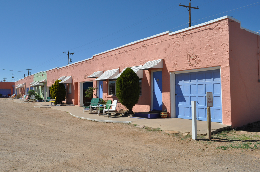
The Blue Swallow Motel was built in 1942 by the local carpenter W.A. Huggins for the prosperous eastern New Mexico rancher Ted Jones. Largely intact and still operating, the motel consists of a combined office and manager’s apartment just off the highway, and an L-shaped building with fourteen units and attached garages tucked safely behind. Besides its distinctive pink-stuccoed exterior with etched shell detailing, the Blue Swallow features metal awnings over the doors, metal casement windows, and metal lawn chairs in front of each unit to create for the guests the feeling of a home away from home. The large blue, neon-lit sign was added in the late 1950s, after the expansion of Route 66. Supported by a steel pole and the office rooftop, the sign creates an entrance canopy that directs guests inside.
Motels also used rooftop signs to attract motorists. The Paradise Motel has the only extant example (circa 1958) in New Mexico. Rising about twenty feet above the hotel roof and visible to passing traffic from both directions, the signs read “Paradise” from the east, and, in larger letters, “Paradise Motel” from the west. Signs with channel-set, neon-lit letters individually mounted to a trussed metal scaffolding made it possible to use larger letters that could be read from greater distances.
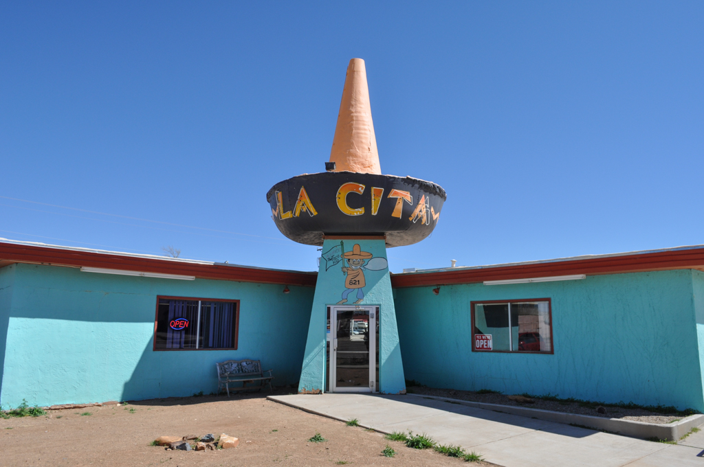
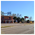
By the 1960s, automobile tourism and the commercial development that had shaped Route 66 in places like Tucumcari began to decline. In 1956, I-40 replaced Route 66 as the nation’s main east-west interstate highway, and what was once a tourist thoroughfare became a sparsely traveled avenue for local traffic. Even so, new businesses continued to try their luck into the 1960s. La Cita Restaurant, built in 1960–1961, boasts a 30-foot-tall, 15-foot-wide painted stucco sombrero that is set off by “La Cita” in large, neon-lit letters, as well as a 25-foot-tall roadside sign, also shaped like a sombrero, which reads “La Cita Mexican Foods.”
The motels, shops, and restaurants that defined Tucumcari in the 1940s and 1950s became obsolete or found themselves with only a local clientele, and the commercial strip along the former Route 66 slowly deteriorated. Because development largely ceased after the completion of I-40 in 1966, Route 66 through Tucumcari remains a remarkably intact example of a cultural landscape shaped by the automobile. Some of the commercial structures have now been restored while recent city initiatives have proposed offering abandoned properties to business owners at low cost to encourage their renovation and contribute to revitalizing an important artifact of Route 66 history.
References
Kammer, David J., “Blue Swallow Motel,” Quay County, New Mexico. National Register of Historic Places Inventory-Nomination Form, 1993. National Park Service, U.S. Department of the Interior, Washington, D.C.
Kammer, David J., “Historic and Architectural Resources of Route 66 Through New Mexico,” Quay County, New Mexico. National Register of Historic Places Inventory-Nomination Form, 1993. National Park Service, U.S. Department of the Interior, Washington, D.C.
Kammer, David J., “Neon Signs Along Route 66 in New Mexico,” Quay County, New Mexico. National Register of Historic Places Inventory-Nomination Form, 2002. National Park Service, U.S. Department of the Interior, Washington, D.C.
Kammer, David J., “State Maintained Route 66: San Jon to Tucumcari,” Quay County, New Mexico. National Register of Historic Places Inventory-Nomination Form, 1997. National Park Service, U.S. Department of the Interior, Washington, D.C.
Thomason, Philip, and Teresa Douglass, “Cactus Motor Lodge,” Quay County, New Mexico. National Register of Historic Places Inventory-Nomination Form, 2005. National Park Service, U.S. Department of the Interior, Washington, D.C.
Warnick, Ron. “Tee Pee Curios Gets New Owners.” Route 66 News, August 1, 2013.
Warnick, Ron. “Tucumcari Proposes Offering Abandoned Property to Businesses at Low Cost.” Route 66 News, May 23, 2014.