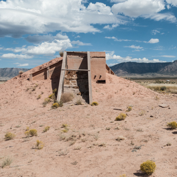
Six of the seven original bunkers survived, at least in part, when Trinity Site was surveyed for the National Register of Historic Places in 1975; at that time, only South 10,000, the control bunker, had been dismantled completely. As of 2014, West 800 is the single bunker that can still be seen when approaching Ground Zero. The remains of the pyramidal West 500 Instrumentation Bunker are in a fenced-off section of Ground Zero that is not accessible to the public, while the instrumentation bunkers at North 800 and North 1,000, and the two other manned observation bunkers at North 10,000 and West 10,000 have reportedly been dismantled.
The West Instrumentation Bunker is a condensed version of the structure used for every bunker: a concrete slab roof set on a supporting framework of oak timbers and enclosed with earth embankments. It was intended to house the Fastax cameras that would be aimed at Ground Zero through three concrete pipes set into the facing earth embankment to record the nuclear explosion at 1,000 frames per second. In the end, however, the cameras were set up outside the bunker in lead-lined boxes. To keep radiation from fogging the film, the camera lenses were angled to mirrors for a reflected view of the explosion.
References
Greenwood, Richard, “Trinity Site,” Socorro County, New Mexico. National Register of Historic Places Registration Form, 1975. National Park Service, U.S. Department of the Interior, Washington, D.C.


