


Located on Route 64 approximately 10 miles outside of Taos, the Rio Grande Gorge Bridge is at once a practical work of civil engineering and an aesthetic commentary on its dramatic geologic site.
The narrow but deep Rio Grande Gorge extends 100 miles north from Embudo into Colorado. It remained a historically impassible barrier to east-west travel and trade in northern New Mexico until the John Dunn Bridge was built in 1908 near Arroyo Hondo some four miles above the present bridge. Reached by a narrow road with steep grades, the Dunn Bridge proved increasingly inadequate to the needs of modern, mechanized transportation and its replacement became a campaign issue in the 1962 gubernatorial election of Jack Campbell.
A new bridge across the gorge was designed by the civil engineer, Herman Tachau, working with the project engineer, Peter H. Bray, under the supervision of Charles E. Reed, chief engineer of the Bridge Design Section in the New Mexico State Highway Department. The structure was fabricated by the American Bridge Company and constructed by the Albuquerque contractor, J.H. Ryan and Sons, Inc., between July 1963 and September 1965.
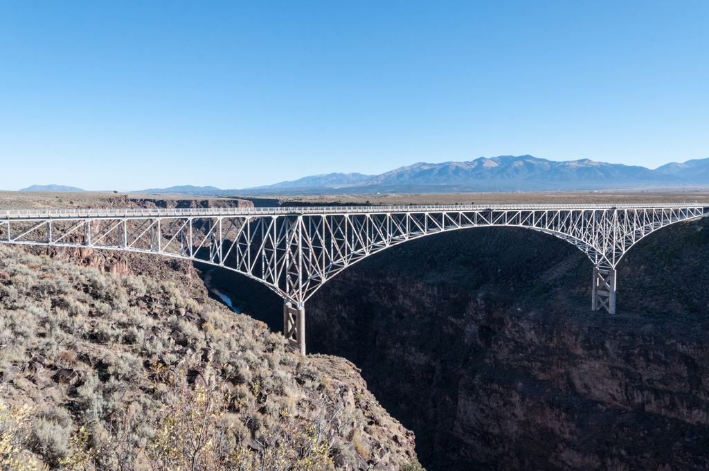
The bridge spans 12,272 feet and crosses the gorge in five sections: two short approach spans of 36 feet, two flanking spans of 300 feet, and a central span of 600 feet. Despite the arched form of the flanking and central spans, the bridge is actually a continuous, cantilevered truss structure using steel box beams. It is anchored by concrete abutments at either end and rests on two, cross-braced pairs of concrete columns. The four arched spans of the bridge cantilever outward in space from those columns in two counterbalanced sections: each flanking approach span acts to counterbalance its matching half of the central span. To minimize weight, the road deck has a concrete-filled steel-grid floor.
This system made it possible to build the bridge without centering, which was not feasible on a plunging site that drops 565 feet from the road deck to the river below. Instead, the spans provided their own structural support during construction, as the box beams were incrementally extended in additive units until they reached either the side abutments or the center. Tied together in the completed structure, the spans pull in continuous tension along the length of the bridge more than they push in compression against the abutments and center.
The Rio Grande Gorge is part of a rift valley, a tectonic rupture in the earth’s crust that reaches across New Mexico from Colorado to Texas and dates back 35 million years to when the North American and Pacific plates began to grind past each other. Cut into a still largely empty plateau backed by the Sangre de Cristo Mountains, formed 5 million years ago, the gorge speaks of ancient geologic forces beyond human time or experience. The bridge comes bravely into this immemorial land, focusing the geology on the distinctly human—and ephemeral—gesture of an attenuated steel structure that leaps across the chasm with balletic if transient grace. In 1966, the American Institute of Steel Construction named it the “Most Beautiful Steel Bridge” in the long-span category.
The bridge can both be driven over and walked across, on sidewalks that lead to balconies cantilevered over the gorge. It is best viewed from a state park overlook on the west side.
References
Kammer, David, “Rio Grande Gorge Bridge,” Taos County, New Mexico. National Register of Historic Places Registration Form, 1997. National Park Service, U.S. Department of the Interior, Washington, D.C.