You are here
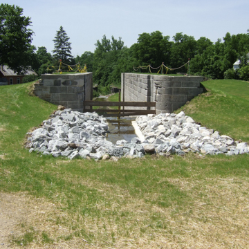
Canal Lock 1 South
Canal Lock 1 South is part of the Lockington Locks Canal system, which once included six locks, an aqueduct to reach the plateau at Lockington, a dry dock, hydraulic feeder basin, feeder canal from Indian Lake, warehouses, and service facilities. This system, located mainly near the center of the town of Lockington, is part of the Miami and Erie Canal that traversed western Ohio from south to north. The section of canal that contains Canal Lock 1 South was originally called the Miami Extension Canal; it ran from Dayton to Junction, near Defiance, Ohio, and was in operation during the second half of the nineteenth century.
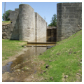
Canal Lock 1 South is impressively engineered, with a white oak timber foundation and walls reach 19 feet, 9 inches in height and are 13 feet, 2 inches wide at the top. It was built of 500-pound cut stone blocks, measuring 36 inches long by 32 inches wide and averaging 10 inches thick in the side and approach walls. These blocks were hauled by ox cart from Dayton, more than thirty miles away. The stone was cut and laid with no more than one-quarter-inch cracks, which were filled with lime mortar. Each lock contained a 90 x 15–foot chamber used to raise or lower boats for navigation.
The Ohio Legislature approved funding to construct a comprehensive Ohio Canal system in 1825 in order to create an efficient and affordable means of transporting to eastern markets its local products, both agricultural and those extracted from the state’s rich natural resources. The Ohio Canal Commission followed New York’s lead, adopting the same specifications for construction that were used to build the Erie Canal. The main channel of Ohio’s canals, like those in New York, was required to be 26 feet wide at the base, 40 feet wide at the water line and 4 feet deep. They were designed for navigation by boats towed by horses or mules on a towpath along one side of the canal.
By 1833, the Ohio and Erie Canal was completed in the eastern part of the state; the Miami and Erie Canal, the western leg, would take an additional 12 years to finish, stretching from Cincinnati to Toledo by way of Dayton. Ohio’s canals were dug mainly by hand with picks and shovels, with teams of horses and oxen used to power slip-scoops and pull wagons. Irish, German, and French immigrants were the primary workers, each laboring on the canal for 30 cents a day, plus food and lodging.
Upon the canal’s completion in 1845, 105 locks were used to raise and lower canal boats along the 248-mile waterway. The section of canal that reached Lockbourne was perhaps the most challenging to build since it traversed the Loramie Summit, 512 feet above the Ohio River level. The canal’s engineers decided to build an artificial water lock from Indian Lake to the east to create a locks that would raise boats 67 feet to the Loramie Summit.
The effect of the canal system on Ohio’s early development was profound. Although the state was endowed with natural waterways at its boundaries, including Lake Erie to the north and the Ohio River to the south, canals provided faster and cheaper access to the more remote towns and cities of the interior. In places like Lockington, the canal lock and its associated properties became the commercial focal point for the town, spurring economic and population growth. The Miami and Erie Canal network brought settlers into western Ohio, provided access to eastern markets for farmers, and helped develop industries and communities deep into Ohio’s interior. As was the case in New York, the success of the Ohio canals was relatively short lived. With the start of the Civil War, canal usage declined and by the 1870s, the railroads had rendered them obsolete.
The Miami Extension Canal was abandoned in 1877 but the Lockington Locks section, including Canal Lock 1 South, remained open for local travel until 1899, when the aqueduct broke. Subsequent natural disasters, including the Great Flood of 1913, combined with years of neglect took their toll on the Lockington Lock system. By the time the state transferred their management to the Ohio Historical Society in 1966, they were in disrepair. Three years later they were listed in the National Register of Historic Places and partially restored.
In 2014, Canal Lock 1 South was more fully restored through a Transportation Enhancement Grant from the Ohio Department of Transportation. The restoration preserves the lock to illustrate the important story of the Miami and Erie Canal and its impact for western Ohio. The four locks are visible at the Lockington site and are maintained and interpreted through a partnership between the Ohio History Connection and the Johnston Farm Friends Council. Today they remain a compelling vestige of a significant piece of historic transportation infrastructure.
References
Borchers, Perry E., “Lockington Locks,” Shelby County, Ohio. Historic American Building Surveys, 1959. Prints and Photographs Division, Library of Congress (HABS OHIO,75-LOCK,1-).
Poh Miller, Carol, “Ohio & Erie Canal Thematic Resource Cover Document.” National Register of Historic Places Multiple Property Documentation Cover, 1978. National Park Service, U.S. Department of the Interior, Washington, D.C.
Porter, Daniel R., “Lockington Locks Historic District,” Shelby County, Ohio. National Historic Landmark/National Register of Historic Places Nomination Form, 1969. National Park Service, U.S. Department of the Interior, Washington, D.C.
Ross, Danielle, “Lockington Locks,” Shelby County, Ohio. Ohio Historic Inventory, 2013. Ohio Historic Preservation Office, Columbus, OH.
Writing Credits
If SAH Archipedia has been useful to you, please consider supporting it.
SAH Archipedia tells the story of the United States through its buildings, landscapes, and cities. This freely available resource empowers the public with authoritative knowledge that deepens their understanding and appreciation of the built environment. But the Society of Architectural Historians, which created SAH Archipedia with University of Virginia Press, needs your support to maintain the high-caliber research, writing, photography, cartography, editing, design, and programming that make SAH Archipedia a trusted online resource available to all who value the history of place, heritage tourism, and learning.


