


Active planning for the Capital Center began in the late 1970s with discussion about the possibility of claiming a roughly 15-acre site stretching from the “Chinese Wall,” made by the curve of the railroad tracks on an elevated embankment into the old Union Station northward to the lawn of the State House. Both the trackage through Providence and its station also required upgrading. What if the money for these improvements could be combined with additional funds to slide the curve of the tracks toward the northern and western edges of the site? The railroad could be given a shorter right of way on ground-level tracks, with a new station built over them at a new, higher artificial grade immediately below the State House. Then the “Chinese Wall” could be eliminated, thereby making available a sizable area for the expansion of the old center city. There were objections, two of particular importance. Some argued that the old station was ideally located at the heart of the city, rather than at some remove from it, as would be its proposed replacement. They also feared that development on the new site could occur only at the expense of the old commercial center. Although much of the old downtown was moribund and in part dilapidated from long and extensive vacancies, it had become the object of passionate concern; many saw that it contained an array of nineteenth- and twentieth-century buildings so exceptional as to be virtually (perhaps actually) unmatched by those in any other medium-sized American city. Not surprisingly, however, expansionist fervor prevailed.
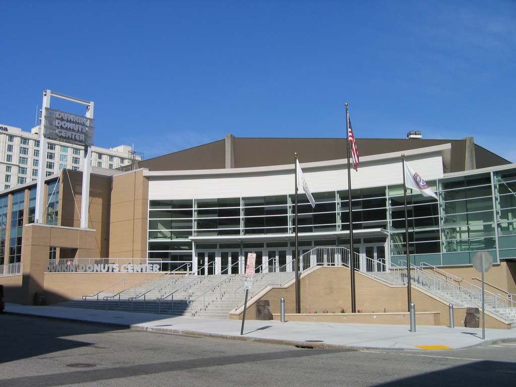
To this initiative for Capital Center add two others, which developed in such an interlocked manner that in effect they became one. First, off the northwest corner of Kennedy Plaza and adjacent to Capital Center, the Convention Center, for trade shows and conferences ( PR8.1; 1985 [planning]; 1991–1993, Howard, Needles, Tammen and Bergenhoff), on Sabin Street, with an adjacent Westin Hotel ( PR8.2; 1992–1994, Nichols Partnership), went up beside an existing and lumpish Civic Center (1971–1972, Ellerbee Architects), for sports and entertainment spectaculars, and better inside than out. Meanwhile, parallel plans called for improving the banks of the two rivers that mark the southern and eastern boundaries of the Capital Center site—the Woonasquatucket and the Moshassuck—joining at the center of the city to make the Providence River.
Virtually the whole of the north end of the river was bridged by 1905 from a point opposite Old Stone Bank north to, and including, the junction of the Woonasquatucket and Moshassuck Rivers. No aspect of the redevelopment of the central city has been more
Moving from Kennedy Plaza into the Capital Center site requires crossing Memorial Boulevard and the parallel Woonasquatucket, which together curve around two sides of Kennedy Plaza. An integral part of Capital Center, the boulevard provides the principal access into it from I-95 and I-195. Ironically, its heavy traffic re-creates the Chinese Wall between the old downtown and its intended expansion, which the track relocation was supposed to have razed. As the umbilicus at the center of this redevelopment site, the Woonasquatucket has been puffed into a granite-lined circular pond to symbolize the ancient treatment of the so-called Cove, which once filled this hollow. Originally the Cove was a pond which, for smaller boats, marked the head of the Providence harbor. As the city grew toward the Cove, its containment within a circle of granite surrounded by a treeshaded promenade converted its swampy stench and mucky squalor into a park (completed in 1856). Only briefly, however, for wastes from growing industrialization upstream soon returned the Cove to a nauseous, derelict condition. Now, this shrunken token of the larger circle of water that was once there resurrects the memory of a moment of elegance from the city's past and recalls the still larger body of water which was the Cove's original state.
Skidmore, Owings and Merrill's New York office supervised Capital Center's master plan. Its good intentions are evident in provisions for lower buildings close to the State House, with increasing height toward Kennedy Plaza, together with a few (but too few) axial vistas from the old downtown toward the State House dome. Such benefits are substantially undone, however, by the large size of most of the plots, reflecting the demands of developers for more extensive floor areas than those typical before the mechanical delivery of light and air made tolerable (if not always pleasant) deep spaces far from windows. Of the first buildings erected on the old Cove site, only Amtrak's Providence Station escapes the architectural deficiencies—especially chunky massing and banal detail—that beleaguer the Citizens Bank Tower, the American Express Building, and Center Place. Thinly detailed symmetrical schemes in a postmodernist classical mode seem stretched to the limit to wrap the bulk, like gift wrapping mammoth presents.
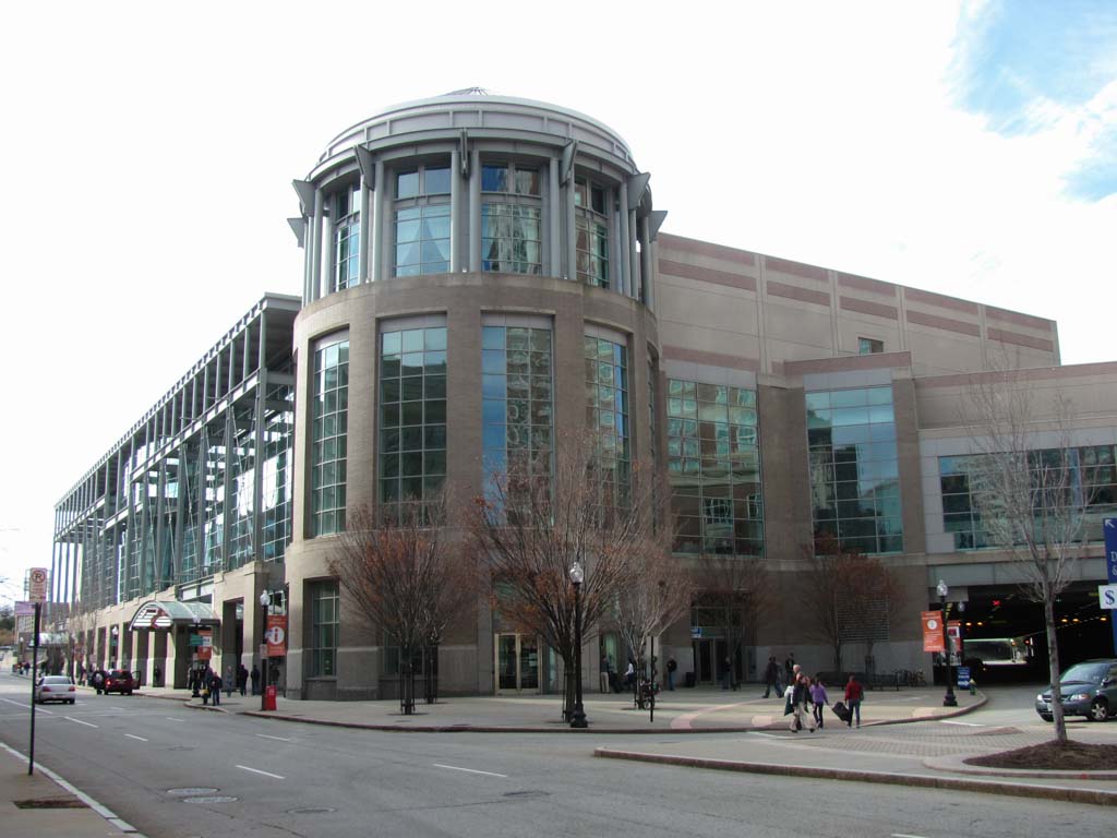
Of these buildings, Providence Station (
PR8.3; 1981–1986, Marilyn Taylor of Skidmore, Owings and Merrill, chief designer), 1 Station Place, is architecturally the most significant. Like the Convention Center, it is postmodernist classical in style. Whereas the giant metal-framed glass front of the Convention Center alludes to a classical portico as a frontispiece to the immense box of space behind, the station is a full-round composition of severe geometrical shapes, possibly too unrelieved but nicely proportioned, which designate the essential functions within. A low, spreading box in reinforced concrete houses the waiting room, topped by a low, metal-clad dome. Inset porticoes, their columns simple cylinders,
Projected as the climax of Cove area building is Providence Place ( PR8.4; 1997–2000, ADD, Inc., architects; Friedrich St. Florian, associate), a colossal shopping mall wedged into the intersection of I-95 and the River Boulevard, directly opposite the Convention Center and its hotel. It also contains four stories of warehouse-like space, compartmentalized into the usual department store “anchors” with shops, restaurants, and theaters in between, all cut through at one point by the mandatory climactic vertical atrium topped by a glass dome. The court and its bubble occur directly over the spot where the Woonasquatucket flows beneath the mall through an oversized, barrel-vaulted orifice. The outermost layer is fronted in classically derived embellishment, much at giant scale, and more seriously conceived than that stretched over earlier office and apartment buildings in Capital Center. The embellishment extends around the southern prow of the complex at the junction of I-95 and Memorial Boulevard. Toward I-95 the mall is walled by parking, like the Convention Center, both curving inward to make the boulevard gorge for access to Capital Center. Is this another Chinese Wall? Will lighting or some other adornment ameliorate the sullen grimness of these parking precipices and beguile the traveler between the Scylla and Charybdis of this new central city?
Even if the current plan is stunted or stymied by economic conditions or its late-1970s direction ultimately changed, Capital Center will interest the architectural pilgrim as a commentary on late twentieth-century urbanism. Has the central city taken its revenge on the suburban mall? Or is the suburban mall the real winner after all? The collection of shops and other enticements in this urban mall is decreed by the developer to be the city's “downtown.” It is mostly sealed off from the city by basement, bridge, or arcade passages to the hotel, from the hotel to the Convention Center, and from there to the Civic Center. Against the overwhelming scale, self-containment, and floor space of this colossus and its satellites, what is the role of what was downtown? This is our next destination.