You are here
Poinsett Bridge
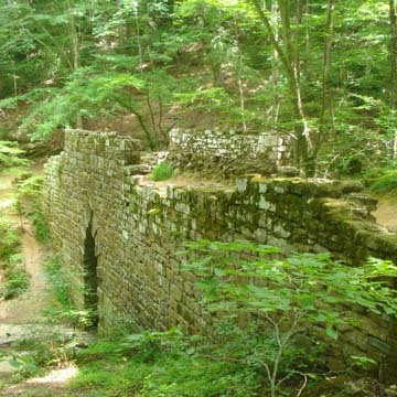
The Poinsett Bridge (originally Gap Creek Bridge) is regarded as the oldest extant bridge in South Carolina, a notable instance of resilient design and solid construction. Joel R. Poinsett, a Charlestonian influential in Greenville, supervised its construction circa July–December 1820 as part of the project to build a South Carolina State Road over Saluda Mountain and into North Carolina. Poinsett, then between terms as a state and U.S. congressman, also directed the construction of the road itself, beginning in 1819. Its route ran from Charleston through Columbia to Asheville, North Carolina.
In the early 1800s, almost all of South Carolina’s rural Upcountry roads were made of dirt and were used to drive livestock to larger towns like Greenville or to facilitate the fur trade. Stagecoach lines connecting Charleston and Greenville also traversed these roads to deliver mail or offer personal transportation. Travel by any wheeled vehicle was almost impossible in the fall and winter months or after heavy rain, when delays were inevitable due to wash-outs, fallen trees, or the interference of cattle or pigs being driven to market. The steep grades of the South Carolina foothills further complicated wheeled travel. The State Road aimed to remedy these conditions, described by state-appointed civil and military engineer John Wilson in an 1817 report as “oppressive and ineffectual.” The first “civilized” thoroughfare linking the Upcountry (Greenville) to the Lowcountry (Charleston) was completed in 1825 with the development of the Saluda Turnpike, which crossed territory where the steep grade of the South Carolina foothills and the tributaries of various rivers made wheeled travel especially difficult. The Gap Creek Bridge was part of the Saluda Turnpike.
Construction on the bridge began in 1820, with Poinsett overseeing the project in his capacity as president of the South Carolina Board of Public Works, and board member Abram Blanding supervising the construction proper. The granite used in building the bridge over Gap Creek was mostly quarried about a quarter-mile east of its span. Its 15-foot-high by 7-foot-wide Gothic arch is constructed of wedge-shaped rocks. The arch itself has a decorative design that utilizes alternating relief in the voussoir stones, with every other stone projecting about one inch from the primary plane of the arch. The passageway above the arch had stepped parapet walls on either side for the safety of travelers. The 130-foot-long bridge has a 24-foot height from the water level to the top of the parapet walls. According to notes from Poinsett’s diaries, he hired 100 stoneworkers from Burn Frankford of Pennsylvania and 50 stonemasons from Jonah Teny of Boston. These skilled northern laborers also completed two other bridges along the Saluda Mountain Road: the North Saluda River Bridge and the Hodges Creek Bridge.
The architect of the bridge is unknown. In 1821, Robert Mills made sketches of the Gap Creek Bridge and other bridges and scenes along the North Saluda River and the State Road, which have been used as evidence of his authorship. Mills’s sketch for the Gap Creek Bridge shows what appears to be a wooden railing along the parapet, which, if included in original construction, has long since rotted away. Mills was appointed as Superintendent of Public Buildings to the South Carolina Board of Public Works in December 1820; however, during the spring and summer of 1820, when designs for the Gap Creek Bridge would have been underway, William Jay was the architect for the Board. Proponents of Mills’s authorship of the Gap Creek Bridge have speculated that Mills may have submitted examples of work and ideas for future projects as he sought a position in the South Carolina internal development industry, perhaps as early as 1817. Moreover, by December 1820, Jay was apparently in disfavor with the Board of Public Works, and many of his original designs were revised to suit Mills’s style just as Mills was presumably preparing to take over his new role. No construction plans or other preparatory documents name a designer of the bridge.
Today, the bridge is no longer in use for traffic and stands within the 12-acre Poinsett Bridge Heritage Preserve.
References
Batson, Mann. Early Travel and Accommodations along the Roads of the Upper Part of Greenville County, South Carolina and Surrounding Areas. Taylors, SC: Faith Printing Co., 1995.
Blackerby, Randall. “Poinsett Legacy in Greenville Remains Strong.” The Examiner, May 4, 2011.
Edgar, Walter. “’P’ is for Poinsett Bridge.” SCETV Radio, July 28, 2015. http://southcarolinapublicradio.org.
Helsley, Alexia Jones. Hidden History of Greenville County. Charleston, SC: History Press, 2009.
Huff, Archie Vernon. Greenville: The History of the City and County in the South Carolina Piedmont. Columbia: University of South Carolina Press, 1995.
Marsh, Blanche. Robert Mills, Architect in South Carolina. Columbia, SC: R. L. Bryan Co., 1970.
McCuen, Anne. “The Poinsett Bridge.” Greenville Magazine(September 2000): 18-20.
New South Associates. Poinsett Bridge: A Historic Context and Archaeological Survey, Greenville County, South Carolina. Report submitted to the South Carolina Department of Natural Resources, July 7, 2004.
Nolan, John M. A Guide to Historic Greenville. Charleston, SC: History Press, 2008, pp. 73-75.
Perry, Lee Davis, and J. Michael McLaughlin. South Carolina Curiosities. Lanham, MD: Rowman and Littlefield, 2011.
Richardson, James M. History of Greenville County South Carolina. Greenville, SC: Southern Historical Press, 1930.
Robert Mills Papers, Southeastern Architectural Archive, Howard-Tilton Memorial Library, Tulane University.
Thomas, Charles E. “Poinsett Bridge: The Oldest Standing Bridge in South Carolina.” Sandlapper4, no. 8 (October 1971): 44-47.
Writing Credits
If SAH Archipedia has been useful to you, please consider supporting it.
SAH Archipedia tells the story of the United States through its buildings, landscapes, and cities. This freely available resource empowers the public with authoritative knowledge that deepens their understanding and appreciation of the built environment. But the Society of Architectural Historians, which created SAH Archipedia with University of Virginia Press, needs your support to maintain the high-caliber research, writing, photography, cartography, editing, design, and programming that make SAH Archipedia a trusted online resource available to all who value the history of place, heritage tourism, and learning.


