

-
 (Courtesy of Bureau of Land Management)
 -
 (Photograph by twbuckner)
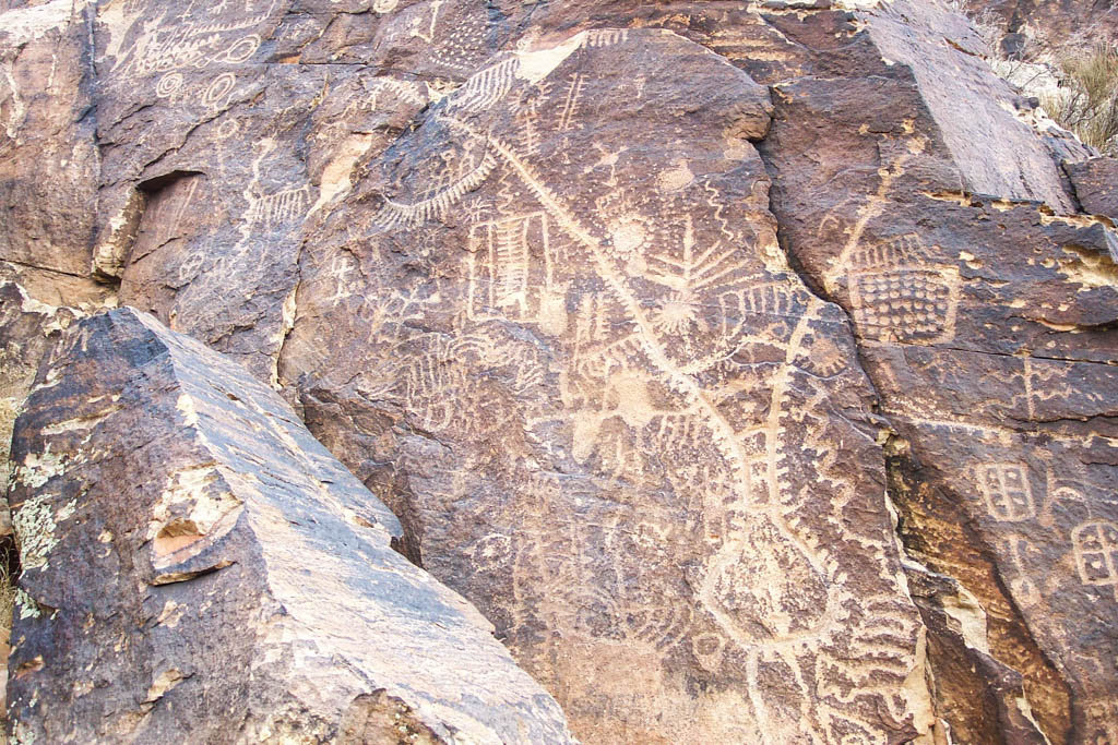


Parowan Gap is a 600-foot deep, V-shaped crevice near Parowan and Cider City in southwestern Utah. It is one of the most important native sites in the state, visited by ancestral natives for at least 5,000 years. Today, it documents Native American landscape intelligence, astrological science, methods of recording time, and trade relations with Mesoamerica.
In topographical terms, the site is a canyon, a “wind gap” carved into the iron-rich Red Hills by a river or a stream millions of years ago. The stream, since dried up and its bed eroded, was either lost due to an unusually swift cropping up of the hills and movement of fault lines, the drying of local climate, or some combination thereof. It functions as a gateway pass between the Great Basin Desert to the west and the Colorado Plateau Mountains and valleys to the east.
Around a thousand years ago, Native American astronomers, members of the Parowan Fremont culture that inhabited the area around the Fremont River in Utah, noticed a remarkable quality of the site. It formed a natural “window” for measuring time and studying celestial objects. They transformed the existing topography into a 3.5-mile long, one-mile wide, and 600-foot-tall laboratory. It was equipped with two technological instruments: an observatory cairn and petroglyphs. The cairn identifies precise positions for watching the sunrise or sunset on specific calendar cycle dates, like the summer and winter solstices. Contemporary archaeoastronomers found that readings collected at these sites align perfectly with those deducted from contemporary mathematical calculations and precision telescopes. The petroglyphs, or rock art, can be convincingly decoded as scientific diagrams, maps, and calendars. Some of these petroglyphs (made by incising, picking, carving, and abrading the surface of rock cliffs) mark sun shadows and produce calendars that divide the year into moon and sun cycles alike. Depicting dots, lines, ladder circles, triangles, trees, combs, serpents, etc., these petroglyphs indicate day, month, season, and year counts for the moon, sun, and Venus star cycles. Map migration glyphs tie into calendar counts.
Cedar City historian William Palmer tells us that there is a hierarchy among sighting places. The most privileged among them are sites, like Parowan Gap, for observing the North Star. Integral to Paiute and other astronomies, the North Star is used to divide the sky into different directions and the day into temporal segments. Parowan Gap thus holds valuable clues as to how native ancestors made sense of the cosmos and related Earth to the heavens. One of the most exciting petroglyphs at the site is the Mesoamerican sacred 260-day calendar at the core of a sophisticated Fremont lunar calendar. It indicates that Parowan Gap fell on the trade route between Ancient Nevada turquoise mines and Toltec peoples in Mexico, and that Parowan Fremont and later people in the area were influenced by timekeeping systems in the South.
Another significant set of markings are thought to be a picture of the Parowan Gap itself. Archaeologist V. Garth Norman, who has called it “nature’s perfect observatory,” believes there is an obvious correlation between the rock art representations and landscape itself. Norman has found that the petroglyphs on the eastern entrance to the gap and photographs of the site mark the length, angles, and curves on the two arms identically. Similarly, the “serpent trail” on the right side of the petroglyph maps the east basin ridges and includes rows of dots that indicate the prime observatory stations for two halves of the year. If one accepts Norman’s claims, this petroglyph would be an example of a representative, observational, and scientifically accurate drawing and mapping.
Other cliffs, boulders, and jagged outcrops on the steep talus slopes through the 300-meter mountain gap are covered with hundreds of petroglyphs that accumulated here over perhaps millennia. Paiute legends and religious traditions have identifiable connections with ancient calendar records at the Parowan Gap. Here one finds not a separation, but an intimate intertwining of science and spirituality, art and language, history and philosophy.
References
Hadingham, Evan. Early Man and the Cosmos. Norman: University of Oklahoma Press, 1985.
Malmstorm, Vincent H. Cycles of the Sun, Mysteries of the Moon.Austin: University of Texas Press, 1997.
Norman, V. Garth. The Parowan Gap: Nature’s Perfect Observatory. An Introductory Interpretative Guide. Springville, UT: Cedar Fort, 2007.
Palmer, William R. Why the North Star Stands Still, and Other Indian Legends. Springdale, UT: Zion Natural History Association, 1973.