


The construction of a 469-mile-long linear park, linking Shenandoah National Park and its Skyline Drive to the Great Smoky Mountains National Park in Tennessee and North Carolina, was proposed in the early 1930s. Starting at the southern end of the Skyline Drive in Rockfish Gap near Waynesboro and passing through twelve Virginia counties, the commonwealth's section of the parkway follows the crest of the Blue Ridge Mountains to the North Carolina line.
Between 1934 and 1935, the engineers of the Bureau of Public Roads and the landscape architects of the National Park Service located most of the parkway's curving roads so that construction could begin in 1935. Landscape architect Stanley Abbott, the parkway's primary designer, viewed the work as a form of sinuous sculpture. Thus he designed the roadway as a ribbon with wayside parks bulging out like “beads on a string, the rare gems in the necklace” “Visual Character of the Blue Ridge Parkway: Virginia and North Carolina,” U.S. Department of the Interior, National Park Service. Abbott saw the composition as one of “fields and fences, lakes and streams, and hills and countryside” framed by the road. To this end, wide rights-of-way as on the Skyline Drive, averaging about one hundred acres per mile, were acquired. At the start of World War II, 170 miles were completed, and 123 incomplete miles opened on a temporary basis.
Roads were built mainly by contractors with PWA funding, but the physical shaping of the landscape into a park was largely done by CCC and WPA workers. In no small measure, these vast projects were aimed at stimulating the struggling economy of Appalachia by providing employment and promoting tourism in the region. The teams of men were set to work correcting the sad condition of the area's land, which had eroded due to excess timbering and poor farming practices. After the workers installed drainage systems and fertilized and seeded the land, and planted trees and shrubs, the restored farmland was in many cases leased back to local farmers.
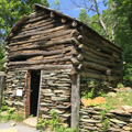
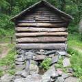
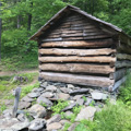
The Blue Ridge Parkway includes 275 overlooks as well as a few overnight accommodations. The parkway buildings, including numerous visitors' centers and shelters, were designed to be harmonious with their rustic setting and finished to approximate the unpainted weathered look of most early mountain structures.
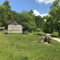
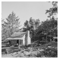
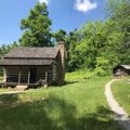
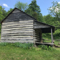
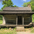
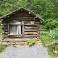
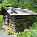
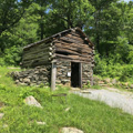
Many of the farmsteads visible from the parkway were allowed to slowly fade away, but some, like the Puckett Cabin Exhibit and the Humpback Rocks Mountain Farm, were restored or rebuilt. The Mabry Mill complex has undergone numerous changes. The decrepit mill was restored in 1942 and other structures restored or moved to form today's small outdoor museum of mountain culture. Usually the farmstead museums along the parkway are not exact restorations or reconstructions but are creations meant to give an impression of mountain ways.
An important aspect, both structural and visual, of the parkway is its approximately 170 bridges constructed of reinforced concrete and faced with local stone. Most of the early masons were skilled craftsmen from Italy or Spain. Their deft touch is also seen on the abundant use of stone on curbing, walls, steps, drainage structures, and road embankments. A variety of wood fencing drawn in ten different designs outlines the landscape. With simple construction methods, native materials, carefully controlled designs, and a unified style applied to even the smallest detail, the artful planning of the Blue Ridge Parkway aims at the appearance of uncomplicated nature.
Writing Credits
Data
Citation
Anne Carter Lee, "BLUE RIDGE PARKWAY", SAH Archipedia, eds. Gabrielle Esperdy and Karen Kingsley, Charlottesville: UVaP, 2012—, http://sah-archipedia.org/essays/VA-02-ART390.
Print Source
Buildings of Virginia: Valley, Piedmont, Southside, and Southwest, Anne Carter Lee and contributors. Charlottesville: University of Virginia Press, 2015, 390-391.
If SAH Archipedia has been useful to you, please consider supporting it.
SAH Archipedia tells the story of the United States through its buildings, landscapes, and cities. This freely available resource empowers the public with authoritative knowledge that deepens their understanding and appreciation of the built environment. But the Society of Architectural Historians, which created SAH Archipedia with University of Virginia Press, needs your support to maintain the high-caliber research, writing, photography, cartography, editing, design, and programming that make SAH Archipedia a trusted online resource available to all who value the history of place, heritage tourism, and learning.