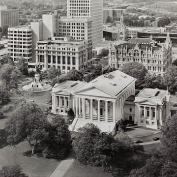
In 1779 the Commonwealth of Virginia decreed that the Richmond plan would be expanded by 200 “squares” or city blocks and that six blocks on Shockoe Hill were to be reserved for state government. In 1780 Governor Thomas Jefferson selected the six blocks that would make up present-day Capitol Square. To center the square on the promontory intended for the future capitol building, Jefferson took half blocks on the north and south. This offset arrangement terminated Franklin Street and Grace Street at the square and created Bank and Capitol streets to the north and south. Through most of its early history the square
You are here
Capitol Square
1780, layout, Thomas Jefferson and Directors of Public Works. 1816, first landscaping plan, Maximilian Godefroy. 1850–1860, second landscaping plan, John Notman. 1906–1922, landscaping
If SAH Archipedia has been useful to you, please consider supporting it.
SAH Archipedia tells the story of the United States through its buildings, landscapes, and cities. This freely available resource empowers the public with authoritative knowledge that deepens their understanding and appreciation of the built environment. But the Society of Architectural Historians, which created SAH Archipedia with University of Virginia Press, needs your support to maintain the high-caliber research, writing, photography, cartography, editing, design, and programming that make SAH Archipedia a trusted online resource available to all who value the history of place, heritage tourism, and learning.


