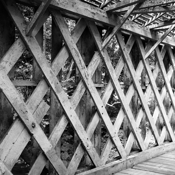
The fifty-four-foot, Ithiel Town wooden lattice truss bridge was reinforced with steel Ibeams in 1969. It occupies a steep, wooded valley where Red Clay Creek makes a hairpin turn and is twice crossed by the Wilmington and Western Railroad (blasted through an adjacent ridge in 1871–1872, a cut so narrow that fast trains risked scraping against the sides). A station was built near the bridge and Wooddale became popular with picnickers. North of the bridge are traces of Delaware Iron Works (active 1814–c. 1890), a sheet-iron rolling mill operated by Philadelphia entrepreneur Alan Wood. A village was centered at Wooddale in the 1890s but disappeared after the last factory, a paper mill, burned in 1918. Of the Red Clay Creek's thirteen bridges shown on an 1868 map, only Wooddale and its near-twin at Ashland (CH35) survived to 2003, when the former was destroyed by the record flood. It is scheduled for rebuilding.
You are here
Wooddale Covered Bridge
c. 1860. Scheduled for rebuilding. Foxhill Ln. over Red Clay Creek, north of Lancaster Pike (DE 48)
If SAH Archipedia has been useful to you, please consider supporting it.
SAH Archipedia tells the story of the United States through its buildings, landscapes, and cities. This freely available resource empowers the public with authoritative knowledge that deepens their understanding and appreciation of the built environment. But the Society of Architectural Historians, which created SAH Archipedia with University of Virginia Press, needs your support to maintain the high-caliber research, writing, photography, cartography, editing, design, and programming that make SAH Archipedia a trusted online resource available to all who value the history of place, heritage tourism, and learning.


