

Ocean View Avenue
You are here
Cannery Row


c. 1900–1945. Bounded by Wave St., Foam St., David Ave., Reeside Ave., and Monterey Harbor.
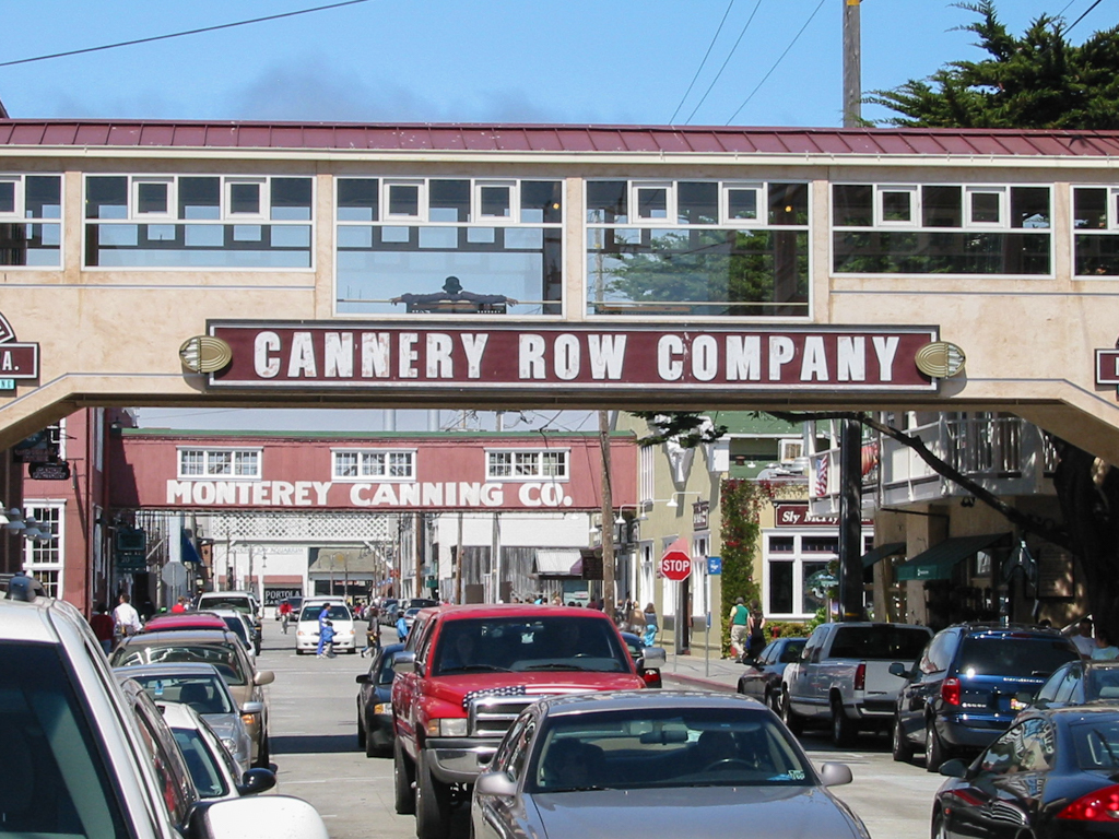


Made infamous by John Steinbeck’s eponymous novel, Cannery Row was originally Ocean View Avenue, a waterfront street in Monterey that once was lined with sardine canning factories. What Steinbeck described in his 1945 book as “gathered and scattered, tin and iron and rust and splintered wood, chipped pavement and weedy lots and junk heaps, sardine canneries of corrugated iron, honky tonks, restaurants and whore houses, and little crowded groceries, and laboratories and flophouses” was a light industrial and commercial area abutting Monterey Bay that emerged circa 1900 and peaked during World War II. Its signature industry began to wane with the demise of the bay’s fishing industry in the mid-1950s; the last canning factory, the Hovden Cannery, closed its doors in 1973. Since then, the row has reinvented itself as a tourist attraction, filled with restaurants, hotels, and shops that overlook the Edward F. Ricketts State Marine Conservation Area, the rocky shore that is home to a large population of California sea lions.
This stretch of seaside had long been a working landscape, filled with the infrastructure and amenities needed to support culturally diverse fishing communities. The coastal roadway began in the late nineteenth century as a northwest-running wagon trail that connected Monterey to Pacific Grove via China Point (now Point Alones), which had been settled by Chinese fishermen and their families as early as 1851. It was these abalone fishermen, who had crossed the Pacific in junks to escape political and economic hardships, who started the large-scale fishing industry in the bay. Although the village at China Point suffered from two conflagrations, the settlement persisted until the third and final fire in 1906 drove the inhabitants farther south. From the 1860s through the 1890s, the area also hosted Portuguese whalers, who used the shore as a whale fat–rendering station until that industry was eclipsed with the development of kerosene. Starting in 1873, Genoese fisherman settled in Monterey via San Francisco and focused on catching mackerel, halibut, salmon, and sardines. Beginning in the 1890s, Japanese abalone divers immigrated to Monterey, as did fishermen from various other cultures, including Scandinavian, Spanish, Vietnamese, and Filipino.
Contemporaneously, tourism played a role in the area’s development. With the arrival of the Southern Pacific Railroad to Monterey in 1874, a nascent leisure industry arose that catered to affluent travelers. The elegant Hotel Del Monte (1880) was built on Ocean View Avenue, while McAbee Beach (just south of China Point) was developed at the turn of the twentieth century by a Scotsman who rented tent cabins and pleasure boats to visitors of more modest means. (This area became the locus of Cannery Row’s second Chinatown, after China Point was abandoned.) What is now the eastern portion of Cannery Row was once the Tevis-Murray Estate. In 1900, Denver millionaire Hugh Tevis purchased a vast property encompassing 1,000 feet of coastline as a gift for his second wife, Cornelia Baxter Tevis, whom he married in April 1901. Tevis died suddenly while on his honeymoon that June, and the estate was sold in 1904 to another Rockies millionaire, James Murray, after its completion. When the palatial manor was under construction, local newspapers questioned whether Monterey would “become the Newport of the Pacific Coast,” but the emerging canning industry quelled those conjectures. Malodorousness plagued Monterey from the late nineteenth century, when the Chinese fishermen took up squid drying on the beaches, through the early twentieth century, when the row morphed into a dense industrial area. Two cottages from the Tevis-Murray Estate— 417 and 425 Cannery Row—are the only remaining vestiges of the area’s early and elite tourist industry.
The town’s canning industry began in 1901, with H. R. Robbins’ sardine cannery on Fisherman’s Wharf. This was followed in 1902 by Harry Malpas and Otosaburo Noda’s Monterey Fishing and Canning Company on Ocean View Avenue, Frank Booth’s mechanized cannery at the harbor in 1903, and the Pacific Fish Company, established on Ocean View Avenue in 1908. World War I fostered a demand for tinned provisions for an overseas army, and between 1916 and 1918, five new canneries and several reduction plants opened on the row, including Norwegian immigrant Knut Hovden’s Food Products Corporation (founded in 1916) and the Monterey Canning Company (1917). In the 1920s, several reduction plants (which turned sardines into fish meal fertilizer) began to crop up on the row, as did tin manufactories and other business related to the trade. At its peak in 1945, the row boasted 16 canneries, which tinned a variety of seafood from salmon to squid, but the mainstay was pilchards or nine- to eleven-inch-long sardines that were abundant in the bay due to an upwelling of cold, nutrient-rich water from the ocean floor. Sicilian-born fishermen in Monterey cornered the market on sardines by using their lampara nets and the “Monterey Clipper,” an open-boat design, and purse seiners to deftly follow and catch what was seasonally referred to as the “silver tide.” For a time, especially through both world wars, Monterey out-produced Norwegian canneries and came to be called the “Sardine Capital of the World.”
Rapid expansion and the industrial nature of the enterprise meant that buildings were often erected from corrugated metal in a simple yet functional manner, such as the Carmel Canning Company Warehouse (1927) at 471 Wave Street and the Monterey Canning Company Warehouse (1917). Other ad hoc, wood-frame structures—such as Ricketts’ Pacific Biological Laboratories (1928)—added to the semblance of temporality and a general aesthetic driven purely by functionality. Very few masonry buildings were constructed, although concrete was often used for foundations and stucco was later used as a cladding material. Large, rectilinear, two-story, open-plan structures punctuated by spare and regular fenestration were built directly atop stilted piers and wharves extending into the water. Each cannery had redwood “hoppers,” or floating, partially submerged storage tanks, into which fishing vessels would unload their daily hauls; large pipes would pump the fish from the hoppers into the canneries. A cannery’s primary building fronted the bay, while second-story, elevated bridges connected the waterfront factories with warehouses on the land side of the street. Some bridges contained conveyor belts that moved finished cans into the warehouses for storage. Railroad tracks behind the warehouses allowed easy loading into freight cars for transport.
Cannery Row was more than a seaside industrial area, however; as Steinbeck described it, it was a complex nexus, with residences, groceries, shops, and restaurants, as well as saloons, bordellos, and gambling dens. The neighborhood had always been a melting pot, drawing populations from fishing cultures across both oceans, but it was also filled with women who operated cafes and stores, supplied the brothels, and worked at the canneries (especially during wartime). While some of Cannery Row’s workers dwelled in town, many lived close enough to the factories to hear the daily whistles blow. The row’s residential section, sited west of the railroad tracks and east of Lighthouse Avenue, peaked between 1920 and 1940 and was characterized by one-room workers’ shacks as well as wood-frame bungalows. These were served by local groceries, such as the Wing Chong Market at 835 Cannery Row, which formed the basis for fictional Lee Chong’s grocery in Steinbeck’s novel. Between 1927 and 1929, in tandem with Monterey’s building boom, the Wu family erected the Ocean View Hotel and annex on McAbee Beach, ushering in a second phase of tourism in the area. However, no easy symbiosis existed between the city’s two economic drivers—tourism and canning—and local political battles (underscored by class distinctions) over odor abatement persisted through the 1930s. By World War II, tourism had ceased to be an important element in Monterey’s economy.
The canning syndicate did not remain dominant for long, and a combination of factors (not the least of which was overfishing) led to the industry’s demise in the 1950s. By 1958, Steinbeck’s noisome, lively Cannery Row had only five operating canneries, and those that survived into the 1960s tinned tuna, anchovies, and mackerel primarily, while all sardine production ceased by 1964. The row lost its industrial vitality and became blighted by abandonment and vandalism. Subsequently, Monterey’s leaders turned to tourism, a solution employed by other boomtowns whose extractive industries had gone bust.
While city planners employed the same formulae that other depressed towns were employing in the third quarter of the twentieth century (such as emphasizing the coastline’s natural beauty, offering recreational activities, and rehabilitating former industrial spaces into museums, restaurants, and shops), Monterey’s trajectory deviated from the standard pattern. The city used its literary pedigree to promote tourism, and thereby preserved much of the row’s industrial character in order to give Steinbeck pilgrims some degree of authenticity. Eight blocks of the street were renamed in 1958 to honor Steinbeck’s 1945 book, as well as his second novel, Sweet Thursday, published in 1954 and set in Monterey’s former industrial milieu. In 1961, the Cannery Row Properties Company (which had been buying ailing factories since 1953) together with city officials, commissioned urban planner Sydney Williams to create a revitalization plan for Cannery Row that introduced new retail, entertainment, professional, residential, and recreational uses while still preserving its industrial nature. Spates of arson and accidental fires gutted many of the abandoned factories through the 1970s, but what was lost was replicated by new examples of industrial architecture. By 1976, the street was redeveloped as a walkable shopping and dining destination with an (albeit artificial) industrial, nostalgic feel.
This renaissance resulted in the preservation and adaptive use of a number of early-twentieth-century industrial buildings, although Postmodernist infill, vacant lots, and the foundations of ruins are also prevalent along the streetscape. The south end of Cannery Row is anchored by the San Carlos Beach Park and the nearby Monterey Plaza Hotel (1985), built atop the old Tevis-Murray Estate, between which lies the best-preserved cannery complex (the Aeneas Sardine Packing Company Cannery and its warehouse with elevated crossing) as well as the best existing example of a fish meal fertilizing factory (the Streamlined Moderne Central Packing Company Reduction Plant), both built in 1945. Loss of the built fabric is evident where the street curves at the junction with Wave Street: a number of vacant lots and ruinous foundations in the 400 block attest to the former presence of the San Xavier Cannery, Warehouse, and Reduction Plant buildings, demolished in the 1990s. Decontextualized preservation praxis is evident at Irving Avenue, wherein three one-room workers’ shacks acquired by the city were relocated in 1990. They are interpreted as Japanese, Filipino, and Spanish families’ housing and are open to the public. The city also purchased, restored, and publicly opened the Pacific Biology Lab at 800 Cannery Row. The north end of the street is anchored by the Monterey Bay Aquarium (1984), housed in the old Hovden Cannery, which was heavily remodeled by the San Francisco–based architecture firm EHDD. The defunct railroad tracks between the row and Wave Street have been transformed into a pedestrian corridor. In 2001, the city created the locally designated Cannery Row Conservation District, which includes and regulates development on most of Cannery Row.
References
Architectural Resources Group. “Final Cannery Row Cultural Resources Survey Report Document.” Prepared for the City of Monterey, California, 2001.
Cannery Row. “The Canneries.” Cannery Row, Monterey, Ca. Accessed November 15, 2016. http://canneryrow.com/.
Chiang, Connie Y. “Monterey-by-the-Smell: Odors and Social Conflict on the California Coastline.” Pacific Historical Review73, no. 2 (May 2004): 183-214.
Chiang, Connie Y. “Novel Tourism: Nature, Industry, and Literature in Monterey’s Cannery Row.” Western Historical Quarterly35, no. 3 (Autumn 2004): 309-329.
“Death Finishes Hugh Tevis’ Wedding Trip.” Los Angeles Herald28, no. 251 (June 8, 1901): 4.
Hemp, Michael. Cannery Row: The History of John Steinbeck’s Old Ocean View Avenue. Carmel, CA: History Company, 2009.
Steinbeck, John. Cannery Row. London: Penguin Books, 1993.
Steinbeck, John. Sweet Thursday. London: Penguin Books, 2008.
Writing Credits
Coordinator:
Emily Bills
If SAH Archipedia has been useful to you, please consider supporting it.
SAH Archipedia tells the story of the United States through its buildings, landscapes, and cities. This freely available resource empowers the public with authoritative knowledge that deepens their understanding and appreciation of the built environment. But the Society of Architectural Historians, which created SAH Archipedia with University of Virginia Press, needs your support to maintain the high-caliber research, writing, photography, cartography, editing, design, and programming that make SAH Archipedia a trusted online resource available to all who value the history of place, heritage tourism, and learning.