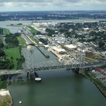
Built at a cost of $19 million, this 5.5-mile deepwater canal permits navigation between the Mississippi River and Lake Pontchartrain and provides a connection to the inland route of the Gulf Intracoastal Waterway and the Mississippi River-Gulf Outlet (completed in 1966, and known as MR-GO). The latter, a deep-draft route through the marshes of St. Bernard Parish, shortened the distance between the Port of New Orleans and the Gulf of Mexico from the 110 miles via the river route to 76 miles. However, the MR-GO allowed saline intrusion into fresh-water marshes, creating ecological havoc. Its role in causing Hurricane Katrina flooding in St. Bernard and the Lower Ninth Ward finally led to its abandonment and closure by the U.S. Army Corps of Engineers after enormous public pressure. Work on the canal began in 1918 under the direction of engineer George G. Goethals (1858–1928), who was also the chief engineer for the Panama Canal locks and, in Louisiana, for the Plaquemine Lock (1895–1909; see Day Trip 3) in lberville Parish. The canal (usually called the Industrial Canal) gives approximately 11 additional miles of waterfront to the Port of New Orleans for wharves, shipyards, and industries. Midway along the canal’s eastern side, a 150-acre railroad yard provides the land-based component of this transportation complex. A 640-foot-long lock to mediate the difference in water levels between the Mississippi River and Lake Pontchartrain is located at the river entrance to the canal; a project to widen it was initiated in 1999, faced public opposition for years, but was brought back to life in 2017 despite the waning traffic using the Industrial Canal. At St. Claude Avenue, the canal passes under the drawbridge of 1919. Originally the truss bridge carried railroad tracks at its center, but these were removed for two additional vehicular lanes. The levee that borders the canal was breached in the aftermath of Katrina, devastating the blocks just downriver from it.
You are here
Inner Harbor Navigation Canal (Industrial Canal)
If SAH Archipedia has been useful to you, please consider supporting it.
SAH Archipedia tells the story of the United States through its buildings, landscapes, and cities. This freely available resource empowers the public with authoritative knowledge that deepens their understanding and appreciation of the built environment. But the Society of Architectural Historians, which created SAH Archipedia with University of Virginia Press, needs your support to maintain the high-caliber research, writing, photography, cartography, editing, design, and programming that make SAH Archipedia a trusted online resource available to all who value the history of place, heritage tourism, and learning.


