


The smallest national park in the state is situated about one mile from the central area of Sitka, a small city in southeastern Alaska. Although the park encompasses just 113 acres of land and water, it is Alaska’s oldest federally designated facility, having been authorized as an important Tlingit fort and battle site by the federal government in 1890. The property became a national monument in 1910 and the National Park Service has supervised the site since 1916, the year the agency was formed. Officially named Sitka National Historical Park (SNHP) in 1972, the facility commemorates both Tlingit and Russian history in Alaska. Located outside the park and closer to the center of Sitka is the Russian Bishop’s House, completed by Finnish log builders in 1842; the building was obtained by the National Park Service in 1973 and restored over the subsequent sixteen years.
The park sits on the western coast of Baranof Island in the Alexander Archipelago of southeastern Alaska, where it is buffered from the full force of the Pacific by numerous small islands scattered throughout Sitka Sound. Situated close to the northern terminus of the Pacific Northwest Coast Biome, the park’s temperate coniferous rainforest is dominated by western hemlock (Tsuga heterophylla) and Sitka spruce (Picea sitchenis). Other important features include the Indian River estuary and several intertidal zones and beach meadow habitats.
While humans have inhabited southeastern Alaska for as long as 11,000 years, archaeological evidence indicates that Tlingit people have occupied the Sitka area for at least 7,000 years. The Tlingit utilized a vast array of natural resources in the Sitka area, especially salmon from the Indian River (the European term for this feature). Numerous fishing camps were located along the banks of the Indian River and the Pacific beachfront. Other local resources were used seasonally for food and the production of materials: shellfish, seaweed, ferns, herbs, berries, spruce wood and roots, hemlock, and alder—all obtained as part of a complex seasonal subsistence pattern that also sustained the Tlingits’ rich culture.
Because of the all-encompassing nature of their hunting and gathering way of life, the Tlingit have always had an intimate relationship with the land, and this, in turn, has always been reflected in the spiritual and social dimensions of their culture. The Tlingit property system, for example, allowed different clans to control and exchange natural resources in specific areas of the land they inhabited. Property ownership was validated in numerous oral traditions that relate their clan origins and crests to these locations. Furthermore, the crests often originated from animal spirits that inhabited the areas in the ancient past. Since ownership and the hunting and gathering activities necessary for survival were inextricably connected to the spirit world, the park serves as an ethnographic landscape that has both historical significance and contemporary meaning to the Tlingit.
The Tlingit’s situation changed dramatically after the arrival of Russian fur traders and colonizers in the 1780s. In 1799, Alexander Baranov, the colonial manager of Russia’s North East Company, established Fort St. Michael in the Sitka area. After several clans attacked the fort and set fire to it in 1803, the Tlingit constructed their own outpost—a wooden palisade that surrounded a set of huts—at the mouth of the Indian River. A year later, in the fall of 1804, a battle between the Russians and the Kiks.ádis clan of the Tlingit established the fort site as a focal point for what is now Sitka National Historical Park.
Tlingit and Russian accounts of the battle differ, but neither dispute that the encounter began when Naval Captain Urey Lisiansky anchored his ship, the Neva, close to the Tlingit’s abandoned winter village. Lisiansky authorized the launch of a barge loaded with sailors and a brass cannon with orders to destroy boats and a warehouse located near the fort. After a brief skirmish the Tlingit drove the Russians back to the Neva. Several days of negotiations followed as the Kiks.ádis waited for assistance and ammunition from neighboring clans. When help failed to appear, the Kiks.ádis evacuated the fort under the cover of darkness, traveling over and around Baranof Island to reach an abandoned village on Peril Strait. During this demanding journey, which the Tlingit called the “Sitka Kiks.ádi Survival March of 1804,” several young warriors were killed in battle, numerous children and elders died, and much clan regalia disappeared. After the Tlingits’ departure, the Russians destroyed the fort and began building the Pacific capital of New Archangel (now Sitka) at the site of the former winter village on Castle Hill.
Although their permanent residence remained on the opposite side of the island, the Tlingit continued to frequent the Indian River area, for hunting excursions and for fishing during the salmon and herring runs. To the Europeans at New Archangel, the Tlingit outside the stockade was a threatening presence, one that restricted the movement of the Russians, Finns, Swedes, and Baltic Germans working for the Russian America Company. By the late 1820s, however, European settlers began journeying to the river and their walks often included a stop at the wooden memorial marking the graves of four Russian sailors killed in the 1804 battle. Scientists also began exploring the area, searching for exotic flora and fauna to display in museums throughout the Russian Empire.
Russian activities intensified during the 1840s and 1850s, when they removed trees for building material and firewood, and cleared land for small gardens. The Russians established several homesteads close to the river’s mouth, a practice that reflected Russian America Company policy allowing retired employees to settle along rivers in the vicinity of their former posts. Ultimately, though, it was the scenic quality and recreational potential of the area that attracted residents who chose to stroll along the “Russian Walk.” According to one Finnish worker, the Indian River was New Archangel’s “only place of amusement.” The destination was just far enough away from New Archangel to serve as a special place where people could retreat from the constraints of town life and enjoy contact with nature.
Sitka served as Alaska’s territorial capital when the United States acquired the Russian Empire’s massive North American landholding in October 1867. While the transfer ceremony occurred in the newly renamed town, the initial American Independence Day celebration took place at the clearing of the former fort site on July 4, 1868. Compared to New Archangel, the size and importance of Sitka declined somewhat after the transfer. The Indian River area, by contrast, remained relatively unchanged, and Sitka’s residents were soon identifying it as Indian River Park. During the mid-1880s U.S. Marines stationed in Sitka cleared a new pathway between the beach and river, thereby bringing into view “all the best points of scenery.” The Marines also built two bridges over the river, including one of rustic design that became a favored destination. Before long the Indian River was attracting hardy tourists who began making steamer excursions through Alaska’s inner passage in the 1880s. (A total of 1,650 tourists traveled to southeastern Alaska in 1884; the figure increased to 2,755 in 1886, and then to 5,000 in 1890.) Several small houses appeared on land (now used by the visitors' center) sited along the shores of Sitka Sound on the western edge of the park along Lincoln Street, which connects the park to Sitka. The residences accommodated young married graduates of the nearby Sitka Training School (later Sheldon Jackson College), an institution Presbyterian missionaries established in 1882 to inculcate Christian values and American cultural practices within the Tlingit community.
During this early period of American control, some large trees and vegetation were removed from the Indian River area, although a mix of old-growth specimens interspersed with young spruce and hemlock and herbaceous plants remained. Also remaining at the river’s mouth was the fort site clearing, described by one visitor as “a pretty little nook . . . from which the trees and undergrowth have receded . . . and left a smooth open space on which the grass is growing.” From that point, noted the writer, “the town is shut out from view.” When, in 1890, U.S. President Benjamin Harrison designated the Indian River area a federally owned public park, his action acknowledged the importance of the fort site and the wishes of Sitka’s residents to protect the river and the surrounding forests and meadows.
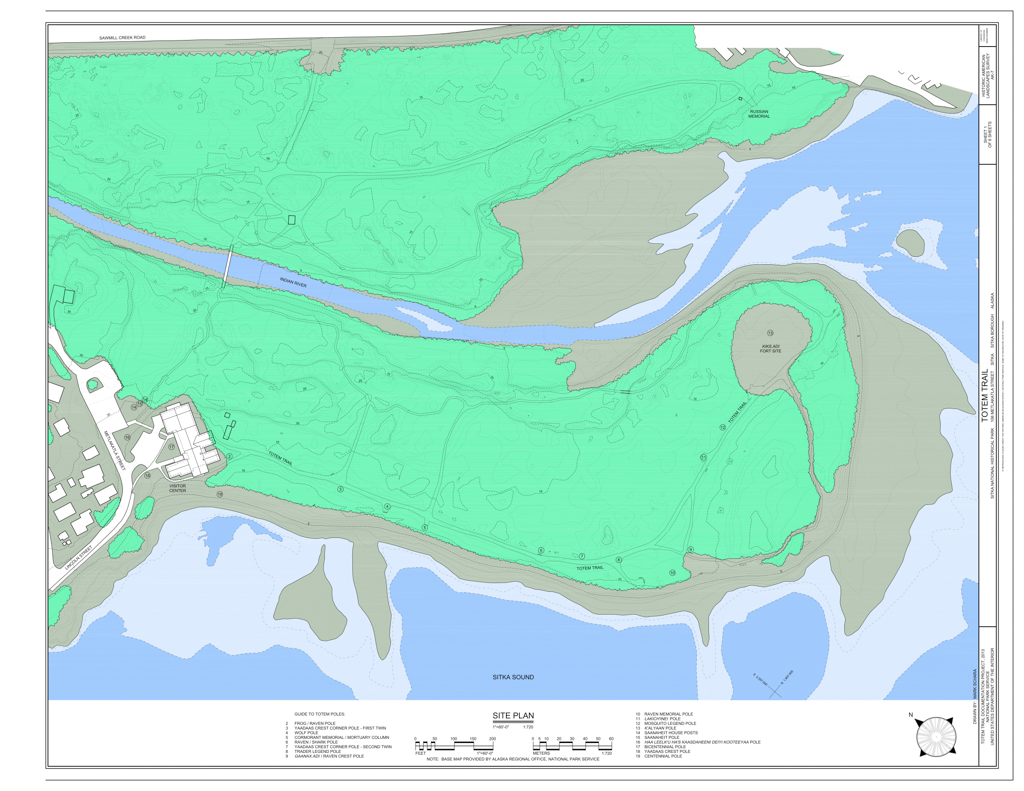
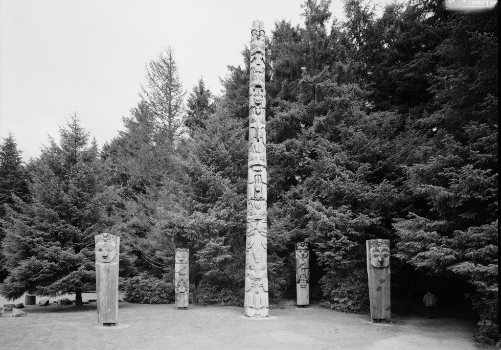
In 1902, a totem pole and four smaller house posts were placed in the park close to the river’s mouth. These additions were followed in 1906 by fourteen more totem poles. Originally from nearby Haida and Tlingit villages, the poles were brought to the park after being displayed at the Louisiana Purchase Exposition in St. Louis. Elbridge Warren Merrill, a local and highly regarded photographer, arranged the totems along the main park road. In 1908, two years after the Alaskan territorial capital was moved to Juneau, the Sitka Arctic Brotherhood petitioned the federal government to designate the park a national monument, and called for the protection of the forest, fort site, Russian graves, and all of the totem poles. President William Taft approved the request in 1910.
As increasing numbers of tourists arrived at the monument, Sitka residents began offering horse-drawn carriage and automobile rides through the grounds. While the scenery remained an important attraction, the totem poles transformed the character of the site, establishing it as a cultural park. By the late 1930s, many poles exhibited considerable deterioration and a Civilian Conservation Corps (CCC) crew was engaged to make repairs. At least five of the original totems were in such poor condition that they were beyond restoration. Native American carvers affiliated with the Works Progress Administration (WPA) were responsible for making their replacements. Today 20 totem poles stand on Sitka Sound, on the coastal trail known as Totem Trail or Lover’s Lane.
When the United States entered World War II, civilian visits to Sitka National Monument were suspended. During the war years, the monument’s resources were exploited to serve the massive military buildup that occurred in and around Sitka. The Indian River channel, for example, became a convenient source of gravel for the construction of a nearby naval air base. The massive excavation effort had destructive and long-lasting effects on the park. Not only was the Indian River degraded, but the removal of trees and vegetation turned the riverbanks into a raw and uneven expanse of bare gravel and debris. A major flood in September 1942 led to an even more drastic reshaping of the river channel and the erosion of many historic trails. Fearing invasion by the Japanese, the U.S. Army also installed searchlights, a fire control station, and several 50-caliber machine guns on the grounds. Intrusions continued into the 1950s, when the government installed a hot-mix asphalt operation along the river. Though some of the scars healed during ensuing years, other devastated areas have never completely recovered.
Not all development in this period was deleterious. The Mission 66 program, implemented by the National Park Service from the mid-1950s to the mid-1960s, provided Sitka National Monument with public facilities that met agency-wide standards, including a visitor center that opened in 1965. Mission 66 also expanded the park’s staff and spurred the development of interpretive programs that featured Tlingit culture and history. These improvements, and the scheduled acquisition of the Russian Bishop’s House, led to the designation of Sitka National Historical Park in 1972.
Since the early 1970s the upper stretches of the Indian River have become more scenic, vegetation has been re-established on many disturbed areas, and major erosion has been curtailed with the installation of riprap at key points. The park’s cultural center also introduced important new programs featuring Tlingit history and artistry. Tlingit carvers working in the cultural center produced needed replacements and new totem poles for the park. In 1976 the “Bicentennial Pole,” marking the 200th anniversary of the United States, was erected close to the visitor center. Another totem, the “Indian River Tlingit History Pole,” was placed nearby in 1996 to commemorate the coming together of the five Tlingit clans who have dwelled in the Indian River area for thousands of years.
The significance and importance of the park’s cultural resources were recognized in 1998 with the publication of a detailed landscape history of the Indian River area. A 1999 Cultural Landscape Report (CLR) provided guidelines for managing the park’s resources. Prepared by Professor Arnold Alanen and graduate student Holly Smith [Middleton], both affiliated with the Department of Landscape Architecture at the University of Wisconsin-Madison, these reports were the first to address cultural landscape issues within an Alaskan national park, and the project received a Merit Award for Research from the American Society of Landscape Architects in 2000. The initial study, which emphasized the role of human agency in shaping the cultural landscape, included the insights of several Tlingit participants who described the importance of the park and the surrounding area as a source of subsistence plants, as a playground, as a site for historically important potlatches, and as a place where legendary birds and animals reside. The CLR addressed some of the challenges of stewardship at SNHP, where natural processes must be protected while important cultural features are simultaneously preserved. Ongoing issues are associated with the evolution of the forest, which has become tall, dense, and structurally more uniform than the former old-growth stands. The totems, originally set in openings among immature spruce and hemlock, have been overtopped and overshadowed by the trees that now loom around them. In recent years, the SNHP staff have employed careful and limited vegetative removal to make the totems more visible and accessible to viewers than they have been in decades. These efforts suggest that Sitka will maintain its historical and cultural importance, even in a state that has so many outstanding wilderness national parks. Today, the park is a twenty-minute walk from Sitka’s city docks, and the fort site is easily accessible from Lincoln Street. Within the park, there are two miles of accessible trails through 113 acres of rainforest, beach, and river landscapes.
References
Lidfors, Kathleen, “Sitka National Historical Park,” Sitka Division, Alaska. National Register of Historic Places Inventory–Nomination Form, 1987. U.S. Department of the Interior, National Park Service, Washington, D.C.
Patrick, Andrew. The Most Striking of Objects: The Totem Poles of Sitka National Historical Park. Anchorage, AK: U.S. Department of the Interior, National Park Service, 2002.
“Sitka National Historical Park: Park History.” National Park Service. Accessed February 8, 2021. Retrieved 10 July 2017. https://www.nps.gov/.
Thornton, Thomas F., and Fred Hope. “Traditional Tlingit Use of Sitka National Historical Park.” U.S. Department of the Interior, National Park Service, July 31, 1998.
Thornton, Thomas. “A Tale of Three Parks: Tlingit Conservation, Representation, and Repatriation in Southeast Alaska's National Parks.” Human Organization 69, no. 2 (2010): 107-118.