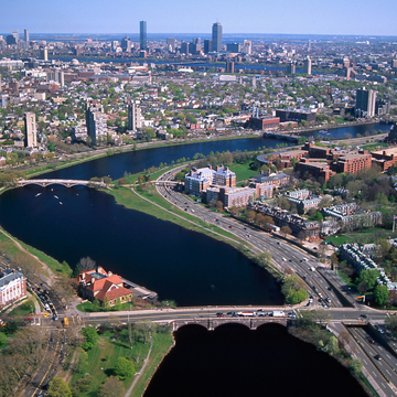
The Charles River Basin, extending from Boston Harbor upstream to the low dam just above Watertown Square (WA5), has been called Boston's Central Park. An open seam between Boston and Cambridge, the Charles looks to all appearances tranquil and unchanging, one of the most visible and carefully preserved natural features of Boston. In fact, nothing could be further from the truth. Two hundred years ago Old Cambridge was separated from Boston by more than two miles of open water—three times the present distance—and by thousands of acres of salt marshes and open unsettled lands extending in all directions from the river's meandering shores. At low tide the bays of the lower Charles became vast expanses of noisome, sewage-laden mudflats. In the nineteenth century the shallow basin of Boston's Back Bay, its nine-mile length edged with mudflats and broad salt marshes, was dammed for mills and filled for commercial and residential ventures. Before the basin's fragmentary creation could begin, the river had first to be imagined as a single public space.
Three signal interventions made possible the construction of this vision: the acquisition of the river banks by the Cambridge and Metropolitan Park commissions in the 1890s; the construction of the Charles River Dam between 1905 and 1910; and the completion in 1936 of the Storrow Memorial Embankment, now universally known as the Esplanade. The park acquisitions established the river's edges as the public domain; the dam stabilized the level of the river and forever covered the fetid mudflats; the creation of the Esplanade greatly enlarged the open margins of the river's shores and established the centerpiece of the emerald-edged “water park” about which Bostonians had fantasized since the middle of the nineteenth century.
Once the construction of the dam was begun, the prospect of new public spaces along the Charles changed the way Bostonians imagined the city's future. Harvard (1913), then MIT (1916), and finally Boston University (1939) established riverfront campuses. The basin, with its expansive views of Boston and Cambridge, became one of the fundamental points of reference against which the visual character of the city is measured and remembered. The view from the river suggests an apparent clarity and visual order in a city otherwise well known for its bewildering and irregular geography. Its form is straightforward; from the Museum of Science, Boston, to the Boston University Bridge, the basin is one extensive, almost regular space. Upstream, though the river narrows and bends, and the views are much less expansive, we imagine this part


