

-
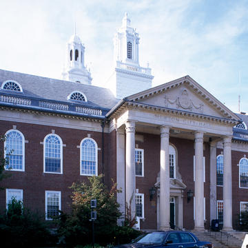 Newton City Hall (Peter Vanderwarker or Antonina Smith)

The construction of Commonwealth Avenue in Newton in the late nineteenth century inspired the investment in large single-family homes for businessmen who could commute to Boston either by trolley or by carriage on one of the paths of Commonwealth Avenue allocated for that purpose. Albert F. Noyes, a former city engineer, designed Commonwealth Avenue in Newton beginning in 1892. Noyes trained at the Lawrence Scientific School in Cambridge and was primarily responsible for the city's waterworks. Construction on Commonwealth Avenue began in May 1894. Extending six miles from the Boston line to the Charles River in Auburndale, its width was designed to be at least 120 feet. As described in the local newspaper at the time, “One of the features in which the Newton boulevard is unique among those constructed in the vicinity of Boston is the absence of tedious perspective. The straight line is nowhere followed. The boulevard is marked by a series of broad curves which give endless variety of scene, and make the steep grades over which it is carried seem gentle slopes.” Little construction occurred along the boulevard until the early twentieth century, when middle-class houses in a variety of popular suburban styles were built. Across the Boston line, the Brighton portion of the road quickly became the location of apartment blocks and row houses. The Newton section, however, was built as it was conceived, as a boulevard lined with freestanding residences.
Commonwealth Avenue proved to be ideal for the construction of a new city hall to replace the old one in West Newton. One of the largest municipal buildings in the region, Newton City Hall (1000 Commonwealth Avenue, NR) actually incorporates two structures. The east half facing a park and Walnut Street serves as City Hall. Designed on an H-shaped plan in the Georgian Revival style with its own cupola, the building is derived from many precedents throughout New England. From the rear of City Hall extends the War Memorial, a rectangular structure with a columned portico and its own tower inspired by the work of Christopher Wren. Constructed
South of City Hall along Homer Street stand two distinguished municipal buildings. Bigelow and Wadsworth provided the initial plans for the Boston Edison Power Station (NR), a one-story Italian Renaissance design begun in 1904 and enlarged in 1910 and 1913 in response to increased demand for electricity, including power for the electric street railway. Kallman and McKinnell added the Theodore Mann Library in 1996, when the main library moved from Newton Corner. The Mann Library responds to the classicizing character of City Hall by creating a symmetrical composition, complete with open cupola, wide overhanging eaves, and a central atrium organizing a highly functional interior.