

St. Mary's Falls Ship Canal
You are here
Sault Locks (St. Mary's Falls Ship Canal)


1855–present. St. Mary's River at Locks Park
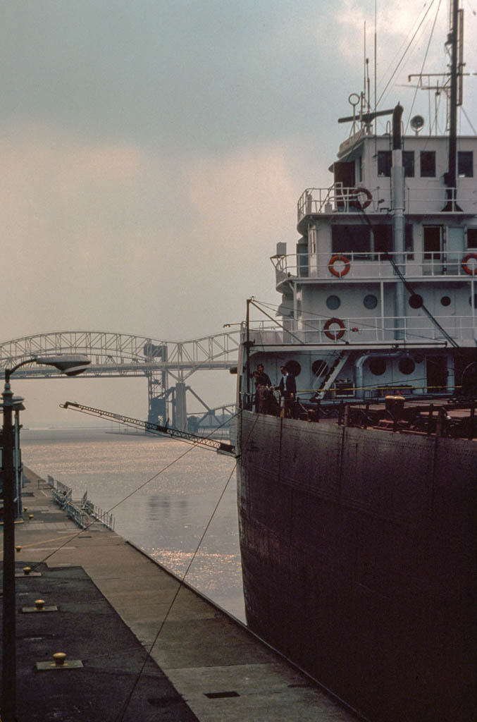
Completed in 1855 under the direction of Charles T. Harvey (1826–1912), the St. Mary's Falls Ship Canal opened shipping around the St. Mary's Rapids between Lake Superior and the lower Great Lakes. This facilitated the passage of deep-draft ships transporting resources from the mineral ranges and forests to the west to markets to the south. Since 1797, there had been at this general location a small, thirty-eight-foot navigation lock for canoes and small craft. That lock was built by the Northwest Fur Company on the Canadian side of the river but was destroyed by American troops during the War of 1812.
In 1855, assisted by a 750,000-acre federal land grant to finance construction, the State of Michigan built the State Lock. It measured 700 feet in length, 70 feet in width, and had two lock chambers, each with a lift of 18 feet. In 1881 ownership of the canal was transferred to the U.S. government under the control of the U.S. Army Corps of Engineers, which still administers the canal. A second lock, the Weitzel, 515 feet long and 80 feet wide, was built between 1870 and 1881. Both the State and Weitzel locks have undergone numerous changes to accommodate larger and larger vessels. Between 1887 and 1896 the State Lock was replaced by the Poe Lock, 800 feet long and 100 feet wide. Two new locks, the Davis (1907–1914) and the Sabin (1911–1919), were added, bringing the total number of operating locks to four. The Davis and Sabin locks, the oldest remaining on this site, are identical, each measuring 1,350 feet in length, 80 feet in width, and 23.1 feet in depth. In 1943 the Weitzel Lock was replaced by the MacArthur Lock, 800 feet long, 80 feet wide, and 31 feet deep, and in 1968 the Poe Lock was replaced by the New Poe Lock, measuring 1,200 feet in length, 110 feet in width, and 32 feet in depth. Construction of coffer dams preparatory to building a large new lock to accommodate the largest bulk carriers began in 2009 and is ongoing. Completion depends on adequate funding.
The administration building (1894–1897, Edward Pearce Casey) is an eighty-foot square, three-story limestone building with a hipped roof and an observation and control tower on its southwest corner. An obelisk (1905) of red Connecticut granite, designed by Charles Follen McKim of the New York City firm of McKim, Mead and White to commemorate the fiftieth anniversary of the opening of the St. Mary's Falls Canal, is located in Brady Park adjacent to the locks. The Sault Locks are a National Historic Landmark.
Writing Credits
×
Data
-
Location: Sault Ste. Marie, MichiganRegional Overviews:Architect:no metadata availableTypes:Styles:no metadata availableMaterials:
What's Nearby
Citation
Kathryn Bishop Eckert, "Sault Locks (St. Mary's Falls Ship Canal)", [Sault Ste. Marie, Michigan], SAH Archipedia, eds. Gabrielle Esperdy and Karen Kingsley, Charlottesville: UVaP, 2012—, http://sah-archipedia.org/buildings/MI-01-CH5.
Print Source
Buildings of Michigan, Kathryn Bishop Eckert. Charlottesville: University of Virginia Press, 2012, 551-551.
If SAH Archipedia has been useful to you, please consider supporting it.
SAH Archipedia tells the story of the United States through its buildings, landscapes, and cities. This freely available resource empowers the public with authoritative knowledge that deepens their understanding and appreciation of the built environment. But the Society of Architectural Historians, which created SAH Archipedia with University of Virginia Press, needs your support to maintain the high-caliber research, writing, photography, cartography, editing, design, and programming that make SAH Archipedia a trusted online resource available to all who value the history of place, heritage tourism, and learning.