

The Sault and Mackinac Region is strategically located at the rapids of St. Mary's River on the international boundary between the United States and Canada, and at the Straits of Mackinac where Lakes Superior, Huron, and Michigan converge. Throughout its long history, Native Americans, missionaries, explorers, traders, soldiers, fishermen, shippers, manufacturers, and resorters have gathered here. At the Sault and at the Straits they built missions, forts, and Indian agencies. On the lakes the federal government built lighthouses and lifesaving stations, vacationers created summer cottages, and transportation companies erected hotels. Along highways businessmen built motels and curio shops. Governments and investors connected both the Upper and Lower peninsulas and the American and Canadian Saults with bridges. They also built locks and a canal ( CH5) and a hydroelectric plant ( CH9) at Sault Ste. Marie.
Michilimackinac, present-day Mackinac County, was created by territorial governor Lewis Cass in 1818 under the provisions of the Northwest Ordinance of 1787. Chippewa County was set off from Mackinac County in 1826 and organized in 1827. St. Ignace and Sault Ste. Marie, the present county judicial seats, are located on the Straits and St. Mary's River, all set against a background of sharply rising hills. Lewis Cass also had led a scientific expedition to the Upper Great Lakes in the 1820s to determine the extent of mineral resources and to promote settlement.
To the east of Point la Barbe and the city of St. Ignace lies Mackinac Island, the uppermost in a chain of three islands that bounds the Straits of Mackinac. Just off the easterly tip of the Upper Peninsula is Drummond Island, again the uppermost in a chain. High rocky bluffs of Niagara dolomite and limestone, so characteristic of the region, not only surround the whole of Drummond Island but also wall portions of Mackinac Island and the eastern Upper Peninsula itself. The mighty eroding action of an earlier sea has shaped these great faces of rock into natural wonders with provocative architectural overtones: they are appropriately called Castle Rock, Arch Rock, Chimney Rock, Sugar Loaf Rock, and Devil's Kitchen and are clearly visible from St. Ignace and Mackinac Island. Both physically and visually, this dramatic geological display must surely have been a factor in prompting the sympathetic handling of stone that marks so much of the architecture of the Upper Peninsula.
Euro-Americans settled the Sault, the Straits, and Mackinac Island before they settled any other place in the Upper Peninsula. The region was not only a center of trade and commerce but also served as a control point for the Northwest. Mackinac Island once was the most important military and fur trading center on the Great Lakes. The struggle to control the Straits led to conflicts between the French and British and later the British and Americans. The French built two forts and the British built one at the Straits ( MK7). The French built one fort and the Americans two at the Sault.
French Jesuits constructed in 1668 a palisaded log chapel and house at the Sault. It became the center for Father Jacques Marquette's missionary work and the first permanent white settlement in the upper Midwest. In 1671, Marquette established a mission chapel named for St. Ignatius of Loyola at the site of present-day St. Ignace, which became the center of French culture in the Great Lakes ( MK4). The mission was abandoned and burned in 1706. Around 1715 the French returned to the Straits of Mackinac and constructed a new fort named Michilimackinac at present-day Mackinaw City, which the British took over in 1761. In 1779 American military successes in the Ohio River valley and elsewhere prompted the British to move Fort Michilimackinac to Mackinac Island. The Treaty of Paris in 1783 ended the American Revolution and made the Straits of Mackinac part of the United States, but the British failed to evacuate Fort Mackinac until 1796. Subsequently the Americans expanded the fort. In 1822 Colonel Hugh Brady and American soldiers built a stockaded fort called Fort Brady at Sault Ste. Marie. New Fort Brady was started in 1892 ( CH13). Lake Superior State University now occupies the site.
Transportation has been important to the Sault and Mackinac Region, which is evident in many buildings in the region. The difficulty of portaging raw materials and supplies around the rapids in the river was solved in the 1850s, when Charles T. Harvey, agent of St. Mary's Falls Ship Canal Company, broke ground for the Sault locks. As compensation for construction, Congress awarded this company of eastern capitalists 750,000 acres of public land. Opened in 1855 the locks permitted the efficient shipping of ore, grain, lumber, and other resources and supplies from Lake Superior to the lakes below. Lumbering flourished in the late nineteenth and early twentieth centuries in the eastern Upper Peninsula. Sawmills were built at Shelldrake, Emerson, Detour, Bay Mills, Drummond Island, and the Sault.
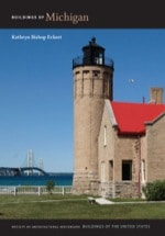
Railroads also increased the importance of St. Ignace when the Marquette, St. Ignace and Sault Ste. Marie and the Duluth, South Shore and Atlantic railroads connected the town with the west. In 1882 the seat of county government was transferred to St. Ignace from Mackinac Island. For centuries boats carried people and supplies between Mackinac Island and the Upper and Lower peninsulas. The Mackinac Bridge Authority was established in the 1950s to construct a bridge ( EM21) to span the Straits of Mackinac between St. Ignace and Mackinaw City. Its opening in the late 1950s linked the two peninsulas.
Mackinac Island has always been an important stopping place for those touring the Great Lakes. From the 1880s, trains and boats brought summer visitors from midwestern cities to enjoy the healthy climate, scenic beauty, and recreational opportunities of the Mackinac area. The Grand Hotel ( MK11) and the splendid summer cottages on the east and west bluffs of Mackinac Island made it the state's premier resort and it remains so today.
Writing Credits
If SAH Archipedia has been useful to you, please consider supporting it.
SAH Archipedia tells the story of the United States through its buildings, landscapes, and cities. This freely available resource empowers the public with authoritative knowledge that deepens their understanding and appreciation of the built environment. But the Society of Architectural Historians, which created SAH Archipedia with University of Virginia Press, needs your support to maintain the high-caliber research, writing, photography, cartography, editing, design, and programming that make SAH Archipedia a trusted online resource available to all who value the history of place, heritage tourism, and learning.