

Minneapolis Chain of Lakes Regional Park; Grand Rounds National Scenic Byway
You are here
Minneapolis Park System
1883–1889, H. W. S. Cleveland, landscape architect; 1889–1905 Grand Rounds, Warren H. Manning, landscape architect; 1970 Grand Rounds improvements, Roger Martin with Eckbo, Dean, Austin and Williams, landscape architects. Calhoun Isles.
-
 Loring Park (Photograph by Alexius Horatius, CC BY SA-3.0)
 -
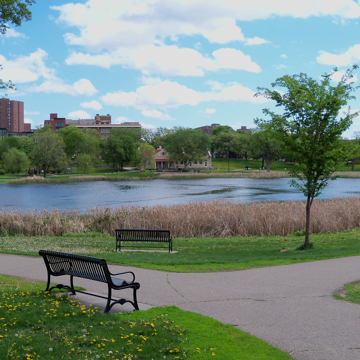
 Loring Park Lake (William E. Fischer, Jr.)


In 1883 H. W. S. Cleveland presented “Suggestions for a System of Parks” to members of the City of Minneapolis Board of Parks, asking them to imagine the city at the turn of the twentieth century, in a time when the growing and prosperous population would desire natural features within the city, natural features that would be irreplaceable if not protected in the nineteenth century. Indeed, Minneapolis’s parks and protected green spaces proved to be an invaluable asset to the city, making it hard to imagine present-day Minneapolis without them.
The Minneapolis Park System was built on what was described at the time as a land of lakes purchased at a bargain. In 1853 the Dakota people signed the Traverse des Sioux Treaty, selling 24 million acres of land to the U.S. government for 7.5 cents per acre. In the following years, more than 100,000 settlers poured into the territory and by 1856 Minneapolis was incorporated as a city. Like other North American cities in the mid-nineteenth century, railroads fueled economic growth and Minneapolis grew rapidly. Technological advancements in flour milling and product transportation made Minnesotan spring wheat the state’s most valuable commodity, spurring the construction of seventeen major flour mills and setting off booms in associated industries like barrel making and machinery. Flour mills were joined by factories for the woolen textile and lumber industries, both running on hydroelectric power from the Mississippi River, whose pump stations drew 2.5 million gallons of water to the city each day. By the early 1880s, Minneapolitans complained about the peculiar color and taste of their drinking water.
Minneapolitans regularly fled from city dirt and congestion seeking respite in the nearby Lake District, where they could participate in sports and other modes of rehabilitative recreation. Starting in 1881, pioneer cyclists, called “wheelmen,” rode bicycles for both recreation and transportation. In 1883 newspapers regularly covered bicycle races that drew about 20,000 spectators.
In 1883, weary of uncontrolled growth and eager for more proximate recreational areas, Minneapolis citizens voted in its first Board of Park Commissioners, whose twelve members were appointed by the Legislature. The Board’s first president was miller and New England transplant Charles Loring, who was an advocate for boulevard improvements through tree planting and who sought the advice of esteemed landscape architect H.W.S. Cleveland to steer the new Board’s work. Perhaps more ecologically oriented than his friend and contemporary Frederick Law Olmsted, Cleveland was averse to overly ornamental landscapes, which he found distasteful and too expensive for the taxpayer. Instead, he encouraged landscape architects to work with existing natural features, arranging them gracefully and economically to suit the needs of society. In cities, Cleveland lamented the imposition of the street grid, arguing for the preservation of the picturesque qualities of hills, valleys, and natural shorelines. In Minneapolis, he urged Loring to maximize the natural beauty of the Mississippi River—the city’s “grand natural feature”—arguing that the picturesque was profitable “at a trifling cost.” In 1883, Loring contracted Cleveland to prepare a comprehensive report. “Suggestions for a System of Parks and Parkways for the City of Minneapolis” was the result.
Cleveland’s plan placed a small “Central Park” (later renamed Loring Park) at the heart of the system, branching out through parkways to the river, lakes, and the State Capitol in neighboring St. Paul. Cleveland believed that parkways—rather than detached open spaces—would dignify and unify the area; thus his system included 20 miles of parkway circulation. The system used broad avenues to connect the Mississippi River to two lakes (Lake Calhoun and Lake Harriet). At the lakes, the avenues would follow the natural shorelines, enclosing each in a green space of trails and roads. Cleveland’s plan also included public park space on either side of the Mississippi River—the “lungs of the city” as he referred to it—thereby setting aside a floodplain that would protect riverbanks from development while pumping fresh air to the city, preventing disease, pollution, and halting the spread of fire. Cleveland recommended thinning existing woodlands in order to plant native shade trees. Landscapes were to be kept naturalistic; landscape ornamentation was left to stately mansions and public works that would later, as Cleveland predicted, line the parkways as land values rose.
The Board got to work implementing the Cleveland plan, first acquiring land for boulevards and then for parks (as prioritized by Cleveland) on a fast-track race against development. Cleveland supplied schematic drawings that he, Loring, and Parks Superintendent William Morse Berry used to direct construction. In 1886, the first parkways around Lake Harriet and around Lake of the Isles opened. His final significant Minneapolis project preserved the area around Minnehaha Falls, which Cleveland revered deeply as an expression of awe and sublime splendor. After the City acquired the Falls in 1889, Cleveland intervened minimally, primarily by connecting it to the larger system with Minnehaha Avenue.
In 1891, Board President Folwell set a vision to completely encircle Minneapolis with parks in a “Grand Rounds”—a vision that would become a reality by 1922. From 1889 to 1905, landscape architect Warren H. Manning completed various projects such as extending boulevards and augmenting park edge plantings. Theodore Wirth, who served as the superintendent of Minneapolis Parks from 1906 to 1935, focused on dredging millions of cubic yards of sand, clay, gravel, and loam to engineer channels between the lakes and deepen and reshape their edges for recreation space. In 1911, the city celebrated the opening of a canal connecting Lake Calhoun with Lake of the Isles. By 1924, the park system had 60 miles of parkways, 33 of which were paved according to standards of the day. Additional properties were steadily acquired in the early twentieth century as the Playground Movement gained momentum. Park construction projects included bathhouses, bathing beaches, a public boathouse, restaurant, public band shell with concession facility, and a pavilion at Lake Harriet (destroyed by tornado and immediately rebuilt in 1925). During the 1930, WPA- and CCC-crews improved and widened roads and dredged swamps to create lagoons.
In the 1950s, interstate highways crisscrossed the Grand Rounds, casting shadows over Minnehaha Parkway and Loring Park. Local landscape architect Roger Martin, working with the firm of Eckbo, Dean, Austin and Williams, recommended extending lake shorelines with islands and peninsulas to maximize their useable space. They also recommended reconfiguring parkways as one-way streets lined with parking and separated pedestrian and bicycle lanes. Standardized design elements, including internationally recognized signage, were added to the Grand Rounds and almost all existing structures were destroyed and rebuilt to then current standards.
Work in the 1980s and 1990s focused on decontaminating lakes and deindustrializing the banks of the Mississippi River. The Clean Water Partnership constructed wetlands at Lake Calhoun and carried out public education programs. Michael Van Valkenburgh Associates developed additional water quality recommendations in 1997. In 1998, the Grand Rounds Scenic Byway became part of the National Scenic Byways Program administered by the Federal Highway Administration. The Chain of Lakes Parks remain popular for walking, cycling, water sports, fishing, sailing, canoeing, sledding, and picnicking.
References
Cleveland, Horace William Shaler. Landscape Architecture, as Applied to the Wants of the West. Amherst: University of Massachusetts Press, 1873.
Gilman, Rhoda R. “Territorial Imperative: How Minnesota Became the 32nd State.” Minnesota History 56, no. 4. (Winter 1998): 154–171.
Hess Roise Consulting. “History of the Grand Rounds.” Minneapolis Park and Recreation Board, 1999.
Manulik, Joseph. “Establishment of the Minneapolis Waterworks, 1867–1910.” MNopedia, Minnesota Historical Society. Accessed March 4, 2017. http://www.mnopedia.org/thing/establishment-minneapolis-waterworks-1867-1910.
Minneaplis Parks and Recreation. “History.” Accessed August 15, 2015. www.minneapolisparks.org.
Nadenicek, D. “Nature in the city: Horace Cleveland’s aesthetic.” Landscape and Urban Planning 26 (1993): 1-15.
Petty, Ross. “Bicycling in Minneapolis in the Early 20th Century.” Minnesota History 62, no. 3 (Fall 2010): 84-95.
Smith, David C. “Minneapolis Park History.” Accessed March 4, 2017. www.minneapolisparkhistory.com.
Streatfield, David. “History of Modern Landscape Architecture.” Lecture, University of Washington, November 29, 2007.
Tishler, William H. “H. W. S. Cleveland, pioneer landscape architect to the upper midwest.” Minnesota History 49, no. 7 (1985): 281-291.
The Cultural Landscape Foundation. “Chain of Lakes.” Accessed March 4, 2017. www.tclf.org.
Watts, Alison. “The Technology that Launched a City: Scientific and Technological Innovations in Flour Milling during the 1870s in Minneapolis.” Minnesota History 57, no. 2 (Summer 2000): 86-97.
Wirth, Theodore. “Minneapolis: a city of parks.” Planning and Civic Comment 9 (October 1943): 1-10.
Writing Credits
Coordinator:
Thaïsa Way
If SAH Archipedia has been useful to you, please consider supporting it.
SAH Archipedia tells the story of the United States through its buildings, landscapes, and cities. This freely available resource empowers the public with authoritative knowledge that deepens their understanding and appreciation of the built environment. But the Society of Architectural Historians, which created SAH Archipedia with University of Virginia Press, needs your support to maintain the high-caliber research, writing, photography, cartography, editing, design, and programming that make SAH Archipedia a trusted online resource available to all who value the history of place, heritage tourism, and learning.