


Fort Macon is North Carolina’s finest and best-preserved example of a Civil War–era beachhead fort. The fort is located on the end of Bogue Island where it looks to the Beaufort Inlet, Shackleford Banks, and the Atlantic Ocean beyond.
Beaufort lies two miles to the northeast, and Fort Macon was constructed to protect this important coastal shipping center. Prior to the fort’s construction in 1826, Beaufort had been occupied by Spanish troops in 1747 and the British in 1782. Two other forts preceded Fort Macon: Fort Dobbs (mid-eighteenth century) and Fort Hampton (1808), which was lost due to an encroaching sea. The fort was one of a series of U.S. coastal forts along the Atlantic seaboard.
Brigadier General Simon Bernard designed the fort following the War of 1812 and construction began in 1826. Named after statesman Nathanial Macon, the fort took the U.S. Army Corps of Engineers eight years to complete. It was garrisoned for the first time in 1834. Even in its early years, the fort was threatened by beach erosion. During the 1840s, with hopes of further preventing the fort from being swept into the sea, Robert E. Lee designed stone jetties that proved effective in controlling erosion on the coastline around the fort.
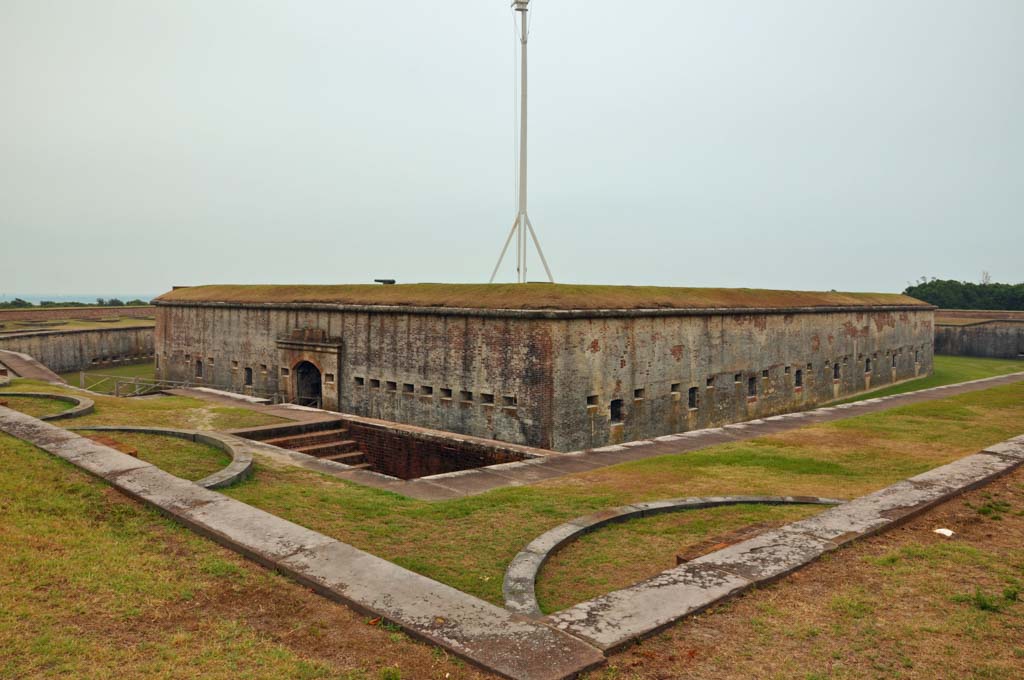
Fort Macon’s plan is an irregular pentagon shape with a nearly concentric series of walls that form a central parade ground, surrounding rooms (casements), and a perimeter moat. Two bridges span the moat on the northeast and southeast sides. The fort is constructed entirely of locally manufactured brick and stone. There are 26 vaulted casements within the fort. The exterior walls are 4.5 feet thick to provide protection from heavy artillery attacks. Doorways and small arched openings puncture the masonry to provide limited light and views to the parade ground and moat. The main parade ground is an open area for the traditional military exercises. It is surrounded by fortified areas where a series of cannons can be mounted on swivels. The grounds connect directly to the interior of the casements; two stone stairways with wrought-iron railings ascend from the parade ground to the roof over the casements. The fort sits sunken into the ground, providing protection from attack as well as limiting the amount it can be seen from the sea. With vegetated roofs, the subterranean fort appears to be part of the landscape.
The fort is best known as a rebel-held post and significant battle site in the Civil War, and it has played a role in several other military conflicts. It was garrisoned in 1842–1844 and again in 1848–1849. Confederate troops overtook the fort at the outset of the war in 1861, and they occupied it for a year before Brigadier General John G. Parke’s Union troops sieged and gained control in 1862. Parke’s attack revealed a major weakness in the fort because, in spite of their thickness, the walls suffered significant damage from cannon balls shot from rifled cannons; this rendered the fort obsolete. From 1862 to 1876 the fort was effectively used as a military prison. Fort Macon was garrisoned briefly in the Spanish-American War of 1898. The State of North Carolina purchased the fort in 1924 and it became the second state park. The Civilian Conservation Corps restored the fort in the 1930s, and the federal government retook control during World War II. It was returned to the state in 1946, which has operated it as a state park ever since. The fort, surrounding grounds, and a nearby visitor’s center are open to the public.
References
“History of the Fort.” Friends of Fort Macon. Accessed February 3, 2019.http://friendsoffortmacon.org/.
North Carolina Division of Parks and Recreation. “Fort Macon State Park History.” North Carolina State Parks. Accessed February 3, 2019. http://www.ncparks.gov/.
Wrenn, Tony P. “Fort Macon,” Carteret County, North Carolina. National Register of Historic Places Inventory–Nomination Form, 1970. National Park Service, U.S. Department of the Interior, Washington, D.C.