You are here
Prairie States Forestry Project (PSFP), Shelterbelt Landscape
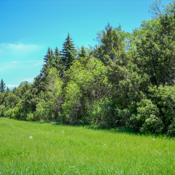
North Dakota’s shelterbelts are a remarkable design feature of the rural landscape, and many are in urgent need of renewal. Franklin D. Roosevelt’s 1934 personal vision, implemented through a New Deal agency, was for a one-hundred-mile-wide band of trees extending twelve hundred miles south from the Canadian border through the Texas panhandle. It was designed to reduce wind velocity, which caused severe soil erosion and dust storms during the “Dirty Thirties.” Shelterbelts, sometimes referred to as windbreaks, were large stands of trees strategically placed on farmland. The CCC and WPA planted the trees as part of the Great Plains Shelterbelt Project, later known as the Prairie States Forestry Project. For this purpose, the CCC along with the U.S. Forest Service established a state nursery near Denbigh (see MH2). Immediate funding for the initiative was limited to one million dollars allotted by the federal government for relief in the drought-stricken states. The project’s value as a work relief program was one of its important contributions. Using labor from CCC and WPA programs and drought-tolerant native plant species, shelterbelts were planted on hundreds of farms and covered thousands of acres across in the state. Several particularly good examples are located between Kindred and Enderlin along ND 46 on the boundary between Cass, Richland, and Ransom counties.
Writing Credits
If SAH Archipedia has been useful to you, please consider supporting it.
SAH Archipedia tells the story of the United States through its buildings, landscapes, and cities. This freely available resource empowers the public with authoritative knowledge that deepens their understanding and appreciation of the built environment. But the Society of Architectural Historians, which created SAH Archipedia with University of Virginia Press, needs your support to maintain the high-caliber research, writing, photography, cartography, editing, design, and programming that make SAH Archipedia a trusted online resource available to all who value the history of place, heritage tourism, and learning.


