


Encompassing 33,000 acres on the southern part of the Pajarito Plateau in northern New Mexico, Bandelier National Monument is an important pre-conquest site of Native American structures and villages, but its name commemorates an immigrant to America, Adolph Bandelier, and the contributions he made to modern archaeology in the United States.
The Pajarito Plateau is a thick layer of volcanic tuff several hundred feet deep that was created by the eruption of the Valles Caldera over a million years ago. There is evidence of human habitation at Bandelier as early as 11,500 years ago, although most of the nearly 3,000 archaeological sites that have been surveyed date from the fourteenth through sixteenth centuries. The people who were drawn to this canyon, starting in the late 1100s, possibly came from Chacoan sites in the Colorado Plateau; the canyon with its year-round creek was well-suited to the needs of an agrarian community. In turn, they might be the ancestors of the historic Keresan Pueblos of Cochiti, Santa Domingo, and San Felipe, after the canyon was abandoned for the Rio Grande Valley in the 1500s.
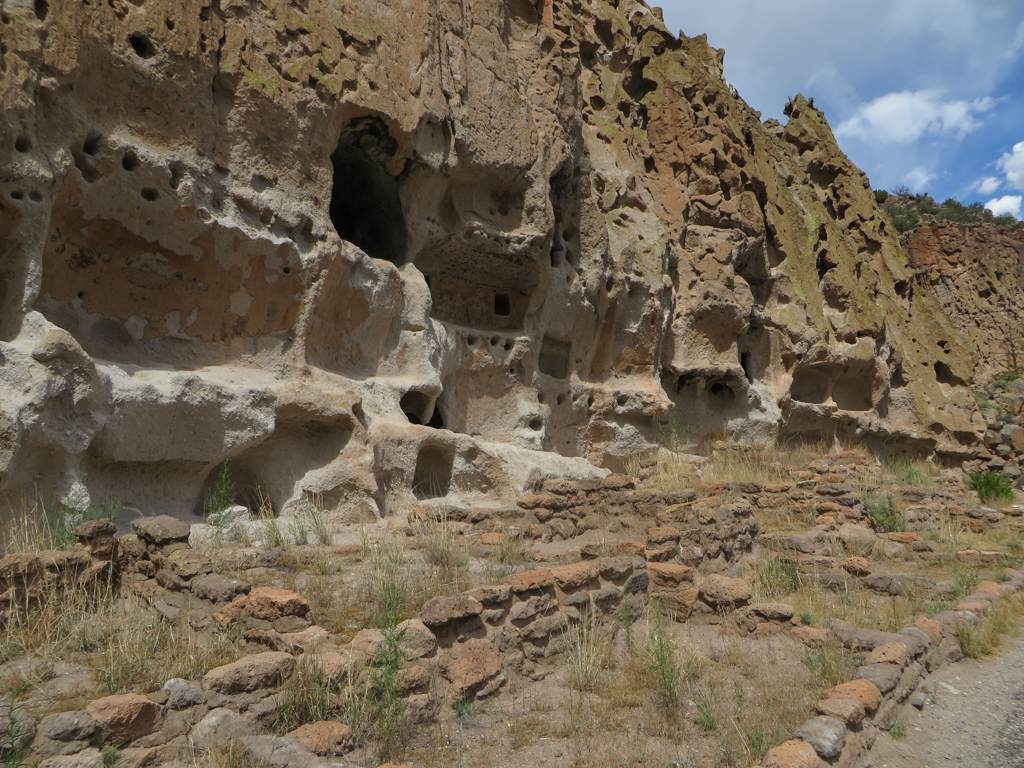
The prehistoric architecture at Bandelier includes freestanding masonry structures, dwellings carved into the soft volcanic tuff of Frijoles Canyon and the surrounding Pajarito Plateau (cavates), and talus structures, which combine masonry structures with cavates. Freestanding buildings constructed from stone masonry can be classified into three categories based on size: 5 communal pueblos (which are masonry structures with 100 or more rooms, usually multistoried); 238 smaller pueblos (masonry structures with between 6 and 99 rooms); and 1151 small structures (masonry structures with less than 5 rooms). The most imposing ruin is Tyuonyi, a roughly oval pueblo with masonry walls and multistory housing blocks around a central plaza that was probably built in stages between circa 1350 and 1550.
Since it is often difficult to distinguish cavates from talus structures, archaeologists tend to classify them together. Bandelier has 4 communal cavate pueblos (clusters of 100 or more cavate and masonry rooms, usually multistoried); 42 cavate pueblos (spatially distinct clusters of 6 to 99 cavate and masonry rooms); and 245 cavate structures (spatially distinct clusters of 5 or less rooms). The cavates indenting the northern side of Frijoles Canyon include 13 major cavate villages located along El Rito de Frijoles and ranging a kilometer in either direction from the monument headquarters.
Archaeologists have determined that the cavate structures were used as dwellings and storage spaces, and ceramic analyses indicate that they date from the same period as Tyounyi and other freestanding masonry structures in the canyon. The cavate village known as Long House, located near Tyounyi, probably contained 300 cavates and masonry rooms during its peak between circa 1440 and 1525. Although cavates may be found in other areas of New Mexico and Arizona, the Pajarito Plateau contains the densest concentration of cavates in the New World and the cavate villages that occupy the plateau’s canyons collectively represent the most important example of troglodytic architecture in North America.
Bandelier also has a number of subterranean and surface round rooms. Often identified as kivas, these include the kiva in the so-called Ceremonial Cave, dating probably after 1350 and reconstructed in 1910. Additionally, there are a large number of minor architectural features including walls, water retention structures, terraces, plazas, stairs, and trails that have been cut into the tuff along Frijoles Canyon.
The monument is named after Adolph Bandelier (1840–1914), a Swiss-American archaeologist, anthropologist, and ethnohistorian who first visited Frijoles Canyon in 1880. He described the canyon as “The grandest thing I ever saw. A magnificent growth of pines, encina, alamos, and tower cliffs, of pumice or volcanic tuff, exceedingly friable. The cliffs are vertical on the north side and…used as dwellings both from the inside, and by inserting the roof poles for stories outside. Aside from the caves, there are ruins of a large pueblo, immense estufas, round towers, of two stories, etc.” Bandelier spent several years working in northern New Mexico for the Archaeological Institute of America, and in 1890 he published The Delightmakers, a novel set in prehistoric Frijoles Canyon. He was followed by Edgar Lee Hewett, the Director of the School of American Archaeology in Santa Fe (established 1907), who conducted the first excavations at the canyon’s archaeological centerpiece, Tyounyi, in 1908; in 1909 and 1910, he expanded his fieldwork to nearby sites.
Efforts to protect the prehistoric remains of the Pajarito Plateau date to at least the early 1900s, and the lobbying of Edgar Hewett (among others) to preserve this and other archaeological sites in the Southwest was key to the passage of the Antiquities Act in 1906. In 1916, the Paharito Plateau became a the Bandelier National Monument under the auspices of the U.S. Forest Service; in 1932, after a failed attempt to expand Bandelier to include cliff dwellings at nearby Puye, the monument was incorporated into the National Park Service, along with the ruins in two outlying areas at Otowi and Tsankawi.
This National Park Services site is open to the public during regularly scheduled hours, with shuttle transportation from the White Rock Visitor Center required for park entry between late May and mid October.
References
Aspen CRM Solutions and the Cultural Resources Staff of Bandelier National Monument. The Grandest Thing I Ever Saw: A Historic Resource Survey of Bandelier National Monument. Los Alamos, NM: National Park Service, Resource Management Division, 2012.
Bandelier, Adolph F. The Delight Makers. 1890. Reprint, New York: Harcourt, Brace, and Jovanovich, 1971.
Hendron, Jerome W. Prehistory of El Rito de Frijoles: Bandelier National Monument. Coolidge, AZ: Southwestern Monuments Association, 1940.
Hewett, Edgar L. Antiquities of the Jemez Plateau, New Mexico. Washington, D.C.: Government Printing Office, 1906.
Hewett, Edgar L. “The Excavations at El Rito de los Frijoles, 1909.” American Anthropologist 11, no. 4 (October-December 1909): 651-673.
Hewett, Edgar L. “The Excavations at Tyuonyi, New Mexico, 1908.” American Anthropologist 11, no. 3 (July-September 1909): 434-455.
Hewett, Edgar L. Pajarito Plateau and its Ancient People. Rev. ed. Albuquerque: University of New Mexico Press; Santa Fe: School of American Research, 1953.
Kohler, Timothy A., Sarah Herr, and Matthew J. Root. "The Rise and Fall of Towns on the Pajarito (A.D. 1375-1600)." In Archaeology of Bandelier National Monument: Village Formation on the Pajarito Plateau, New Mexico, edited by Timothy A Kohler, 215-264. Albuquerque: University of New Mexico Press, 2004.
Powers, Robert P., editor. The Peopling of Bandelier: New Insights from the Archaeology of the Pajarito Plateau. Santa Fe: School of American Research, 2005.
Powers, Robert P., and Janet D. Orcutt. The Bandelier Archeological Survey. Santa Fe: U.S. Department of the Interior, National Park Service, 1999.
Stuart, David E. The Magic of Bandelier. Santa Fe: Ancient City Press, 1989.
Stuart, David E. Ancient Southwest: Chaco Canyon, Bandelier, and Mesa Verde. Albuquerque: University of New Mexico Press, 2010.
Toll, H. Wolcott, with contributions by Peter J. McKenna and June Crowder. An Analysis of Variability and Condition of Cavate Structures in Bandelier National Monument. Santa Fe: U.S. Department of the Interior, National Park Service, 1995.