


The Aztec Ruins National Monument occupies approximately 27 acres in the Animas River Valley of northwestern New Mexico, and is one of the largest and most monumental Chacoan settlements outside of Chaco Canyon.
The identity of its inhabitants remains a subject of debate. The two great houses of Aztec East and West, built respectively in the early and late twelfth to thirteenth centuries, were both modeled after Pueblo Bonito at Chaco. Almost identical in size, these are the largest great houses outside of Chaco Canyon and they anchor a complex of structures that certainly rivaled and perhaps succeeded Chaco as the center of its empire. The site continued to be occupied after the collapse of Chaco in the twelfth to thirteenth centuries, and contains extensive material evidence of modifications in the thirteenth century by people from the distinct ancient culture of Mesa Verde.
Aztec Ruins are also intimately associated with the archeologist Earl Morris, who excavated and reconstructed the site from 1916 to 1934. Morris began work in 1916 under the auspices of the American Museum of Natural History. Until 1923, when the site was declared a national monument and Morris became its first custodian, he focused on West Ruin; from 1933 to 1934, he oversaw the reconstruction of the West Ruin great kiva. Morris started excavating East Ruin in 1927, but never completed the project.
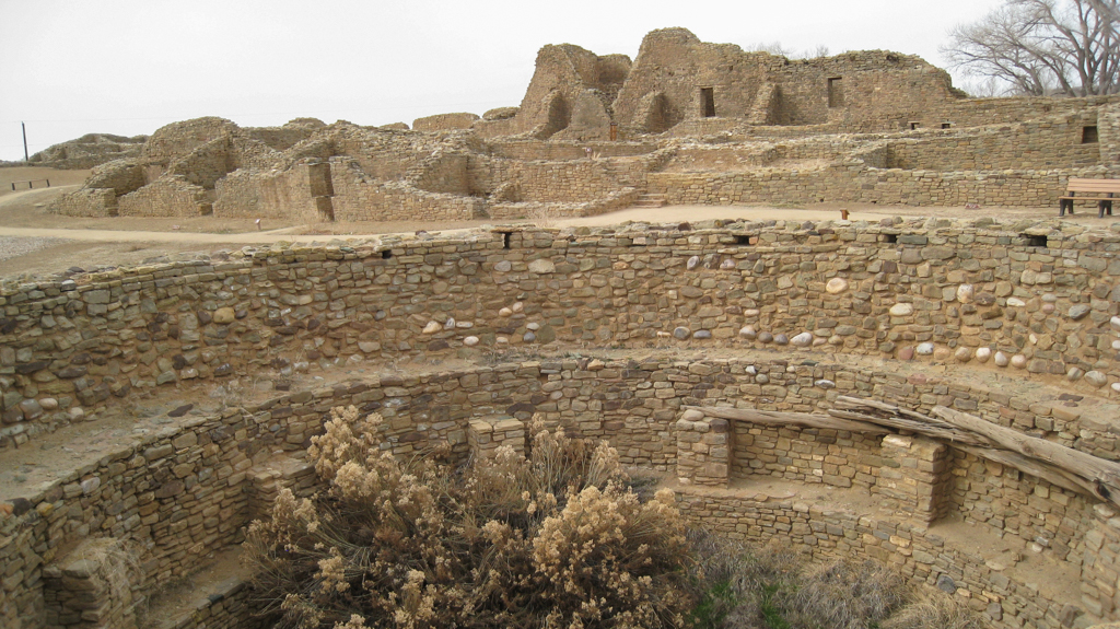
Built between circa 1100 and circa 1130, West Ruin measures 359 x 280 feet. It contains 221 ground floor rooms and is estimated to have had as many as 353 rooms in a structure that once stood three stories. The great house is laid out in a U-shape plan that faces southeast across a large plaza, with rectangular blocks on the north, east, and west sides, and a curved wall of single rooms enclosing the plaza on the south side. A great kiva, 48 feet in diameter, dominated the plaza; 28 other probable kivas are located both around the plaza and inside the room blocks. Morris found evidence that construction of the West Ruin began with a large earth platform, and he concluded that the entire building must have been planned from the outset.
The masonry walls use the same core-and-veneer construction used in Chaco Canyon, but the locally available sandstone did not fracture like the Chacoan sandstone into neatly tabular pieces and produced instead alternating banded courses of thick blocks and thin chinking. One course in the exterior western wall and in several interior rooms used a striking green stone from a source that has yet to be identified. The walls were plastered with clay inside and out, and some interior rooms were finished with white gypsum over red wainscoting. The original ceilings in nineteen ground floor rooms are an exceptional document of Chacoan building techniques; beams of pine or juniper, spanning the narrow dimensions of each room, are covered with poles of pine, juniper, or cottonwood, completed with willow matting, juniper splints, and packed earth.
Measuring 361 x 277 feet, East Ruin has yet to be systematically excavated and documented, but it is the last first-order Chacoan great house and the only example from the late twelfth to thirteenth centuries. East Ruin is similar to West Ruin in size and layout, although its orientation is more directly south and its plaza held a significantly larger great kiva; with an estimated diameter of 67 feet, this is the second-largest great kiva in the Chacoan world (exceeded only by the great kiva at Peñasco Blanco in Chaco Canyon).
The parallels between the West and East Ruins and Pueblo Bonito in Chaco Canyon are striking. All three have high room blocks that surround a central plaza, employ core-and-veneer masonry, have ceilings of similar height and construction, possess T-shaped and unique corner doorways, and incorporate subterranean, semi-subterranean, and elevated kivas. They are also related by their astronomical alignments; the north wall of West Ruin aligns with the summer solstice sunrise and the winter solstice sunset, whereas the south wall of Pueblo Bonito aligns with the rising sun on the solar equinoxes. The great kivas at Aztec Ruin and in Chaco Canyon are virtually identical.
Equally significant differences between the architecture of Aztec Ruins and Chaco Canyon have led to speculation that people from Mesa Verde in southwestern Colorado came to live at Aztec in the thirteenth century. Some of the Aztec kivas are in the “Chacoan style,” while others are in the “Mesa Verde style.” These kivas have niches in their southern walls, giving them a characteristic keyhole-shape, and they also have a sipapu, a small indentation in the floor that contemporary pueblo peoples believe to be the place through which their ancestors emerged. Ceramic artifacts from Aztec further support the possibility that Mesa Verdian culture became an important influence at Aztec.
The complex also includes the Earl Morris Ruin, which measures 177 x 56 feet and appears to be connected to the East Ruin by a causeway. There are also at least three Chacoan tri-wall structures, which are extremely uncommon and whose purpose remains unknown: the Hubbard Tri-Wall, Mound A, and Mound F. These tri-walls are arranged with the West and East Ruins in a quincunx. Some archaeologists believe that this geometric relationship was planned and that the five structures functioned as an architectural ensemble.
Physical remains of the Great North Road that originates at Chaco Canyon have been not been found beyond Kutz Canyon, but its trajectory leads to Aztec, suggesting that it may have been intended to intersect with the complex of buildings and connect Aztec to the larger Chacoan landscape.
This National Park Services site is open to the public during regularly scheduled hours.
References
Fowler, Andrew P., and John R. Stein. “The Anasazi Great House in Space, Time, and Paradigm.” In Anasazi Regional Organization and the Chaco System, edited by David E. Doyel, 101-122. Anthropological Papers No. 5. Albuquerque: Maxwell Museum of Anthropology / University of New Mexico, 1992.
Lister, Robert H., and Florence C. Lister. Aztec Ruins on the Animas: Excavated, Preserved, and Interpreted. Albuquerque: University of New Mexico Press, 1987.
Lister, Robert H., and Florence C. Lister. Aztec Ruins National Monument: Administrative History of an Archeological Preserve. Professional Papers No. 24. Santa Fe: National Park Service, Division of History, Southwest Cultural Resources Center, 1990.
Morris, Earl H. The Aztec Ruin (1919). In Anthropological Papers of the American Museum of Natural History, Vol. 26: The Archer M. Huntington Survey of the Southwest, The Aztec Ruin, edited by Clark Wissler, 1-108. New York: American Museum Press, 1928.
Morris, Earl H. Notes on Excavations in the Aztec Ruin (1928). In Anthropological Papers of the American Museum of Natural History, Vol. 26: The Archer M. Huntington Survey of the Southwest, The Aztec Ruin, edited by Clark Wissler, 259-420. New York: American Museum Press, 1928.
Stein, John R. and Peter J. McKenna. An Archeological Reconnaissance of a Late Bonito Phase Occupation near Aztec Ruins National Monument, New Mexico. Santa Fe: Division of Anthropology, Branch of Cultural Resource Management, Southwest Cultural Resources Center, National Park Service, 1988.