

The Front
Front Park


1868–1876, Olmsted, Vaux and Company; 1891 addition, Frederick Law Olmsted. Bounded by Porter Ave., Busti Ave., Peace Bridge, and the Niagara Thruway.
The Front (now called Front Park) was designed in 1871 as the second parkland in Olmsted and Vaux’s scheme for Buffalo’s park and parkway system. Lying just north of the Erie Canal, The Front formed the western node of the arc of greenspaces that Olmsted overlaid atop the city’s gridiron. The site abutted the old Fort Porter (1841–1844), which was partially integrated into the park after Congressional authorization in 1870.
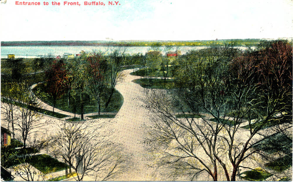
Created from 32 acres spanning an elevated, 60-foot bluff above the headwaters of the Niagara River, Olmsted designed The Front as a formal counterpart to The Park, the naturalistically styled pleasure ground that formed the focal point of the larger plan. The Front’s main attraction was 3.5-acre, gravel-surfaced concourse called the Terrace, overlooking Lake Erie and the distant Canadian shores. Intended for active recreation, The Front featured a large, elliptical playground (a 7.5-acre greensward) north of the amphitheater-shaped terrace. Screening these two open spaces, and the steep slopes leading down to the canal, were thick stands of trees and shrubbery through which footpaths and carriage drives meandered. Trees removed during the construction of Porter Avenue were replanted here, giving the grounds a mature appearance from the outset. Perhaps because of the lushness of the vegetation, The Front was the most popular of Olmsted’s three parks in the first decades after their establishment.
To accommodate the high number of visitors to the Front, the federal War Department allowed the Buffalo Board of Park Commissioners to extend a park drive through the grounds of Fort Porter, connecting the urban grid north of the complex with The Front’s main carriage route. Approved in 1880, the drive was completed in 1886, hugging the cliff’s edge and offering another prospect of expansive waterfront views. The Lake View House refectory, a double-balconied, Stick Style wooden edifice, was also built in response to visitor demands, erected on the terrace in 1882 to designs by architect Eugene L. Holmes. It was demolished in 1898 and replaced by an octagonal granite and wood bandstand designed by Fred Harvey Loverin, along with a stone shelter house. In 1915, a statue of Commodore Oliver H. Perry was erected on the terrace in observance of the centennial of his victory over the British Navy in the Great Lakes.
In 1890, the Board of Park Commissioners acquired twenty waterfront acres on the opposite banks of the Erie Canal. A bridge was built to connect the original park with the addition and Olmsted designed the expansion in 1891, proposing to equip it with a bathing beach, a small boat slip, a boathouse, and a boys’ gymnastics playground. This scheme was never fully realized and the southernmost portion of the addition was transferred to the municipal government in 1908 for a water pumping station and filtration plant. The remainder of the addition, conceived from its inception as a place for active recreation, boasted eight baseball diamonds, two playing fields, four tennis courts, a cricket pitch, a toboggan slide, and an ice-skating rink by 1931.
In 1921, Fort Porter, by then fully abandoned by the military, was chosen as the site of a new Peace Bridge to connect the United States to Canada. Construction of the bridge between 1925 and 1927 necessitated the destruction of the old fort buildings as well as large swathes of parkland. Further expansions of the bridge in the 1950s swallowed additional park acres and between 1943 and 1956, The Front was further compromised by the construction of the New York State Thruway, which followed the bed of the defunct Erie Canal. The bandstand was demolished in 1950 and replaced by a visitors’ center in 1957. Although significantly altered in the middle of the twentieth century, key elements of Olmsted’s original design for The Front remain.
References
Broderick, Stanton M. “Buffalo’s Olmsted Parks and Parkways System.” Olmsted in Buffalo. Accessed March 16, 2021. https://www.olmstedinbuffalo.com/.
Kowsky, Francis R., ed. The Best Planned City: The Olmsted Legacy in Buffalo. Buffalo: Burchfield Art Center, 1992.
Kowsky, Francis R. “Municipal Parks and City Planning: Frederic Law Olmsted’s Buffalo Park and Parkway System.” Journal of the Society of Architectural Historians 46 (March 1987): 49-64.
Rogers, Elizabeth Barlow. Landscape Design: A Cultural and Architectural History. Harry N. Abrams, Inc., 2001.
Ross, Claire L., “Olmsted Parks and Parkways Thematic Resources,” Erie County, New York. National Register of Historic Places Registration Form, 1982. National Park Service, U.S. Department of the Interior, Washington, D.C.
Writing Credits
Coordinator:
Thaïsa Way
If SAH Archipedia has been useful to you, please consider supporting it.
SAH Archipedia tells the story of the United States through its buildings, landscapes, and cities. This freely available resource empowers the public with authoritative knowledge that deepens their understanding and appreciation of the built environment. But the Society of Architectural Historians, which created SAH Archipedia with University of Virginia Press, needs your support to maintain the high-caliber research, writing, photography, cartography, editing, design, and programming that make SAH Archipedia a trusted online resource available to all who value the history of place, heritage tourism, and learning.