

Niagara Reservation; Niagara Falls State Park
You are here
Niagara Falls


1887 plan, Frederick Law Olmsted and Calvert Vaux, landscape architects; 1954–1961 parkway and dam, Robert Moses; 1980–1982 master plan, EDAW, Inc., lead planners; Parsons Brinckerhoff Quade and Douglas, engineers; 2000 Prospect Park and tower, Hardy Holzman Pfeiffer Associates; Erdman Anthony, engineers; Trowbridge Wolf Michaels Landscape Architects, landscape architects; 2008 Greenway master plan, Wendel Duchsherer Architects and Engineers, planners; 2013 improvements and island rehabilitation, Trowbridge Wolf Michaels Landscape Architects; Erdman Anthony, engineers; 2014–2017 Robert Moses Parkway South Riverway, Mark Cerrone, Inc., contractor. 24 Buffalo Ave.
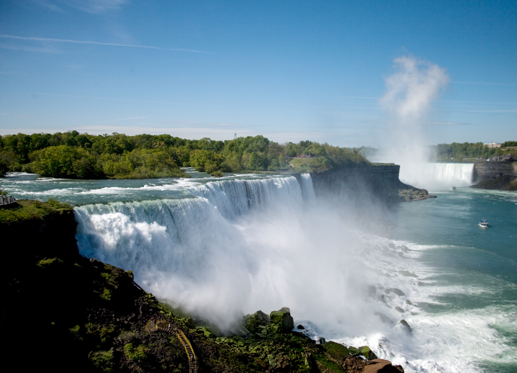
Niagara Falls is a group of three distinct waterfalls—Horseshoe Falls, the American Falls, and the Bridal Veil Falls—on the border between the United States and Canada. The waterfalls, often described as a natural wonder, have been a major tourist attraction since the early nineteenth century. Although the U.S. government declared the area a work of “conservation” when it designated Niagara State Falls State Park a National Historic Landmark in 1966, the experience of the Falls, the islands above them, and the gorge below, are actually a designed and engineered environment, established over many years.
The international boundary line, originally drawn through Horseshoe Falls in 1819, has long been in dispute due to natural erosion and construction. More than 6 million cubic feet of water go over the Falls every minute during peak daytime tourist hours. The Canadian Horseshoe Falls drops an average of 188 feet into the Lower Niagara River. The crest line of the Canadian Horseshoe Falls is approximately 2,200 feet wide.
In 1806, the State of New York sold the land adjacent to Niagara Falls to private interests. In 1846, the Maid of the Mist boat was launched as part of a planned ferry route between New York and Toronto. Originally designed to carry a stagecoach and four horses, the ferry soon proved to be economically unviable. In 1848 its owners decided to transform it into a tourist attraction, offering a journey that would take visitors closer to the Falls. The success of this venture led Captain R. F. Carter and Frank LaBlond to form the Maid of the Mist Corporation in 1884, launching their new boat on June 13, 1885. This corporation, and its boat services, continue to operate today under the Glynn family.
By the end of the 1870s, much of the land on both sides of the border had been developed with water-powered industries, billboards, and tourist concessions. One of the few places that retained some of its natural character, Goat Island, was privately owned and charged entry fees to visit. Even that was threatened since plans had been proposed for the island’s industrial development. During the 1870s and 1880s, prominent Americans began to campaign for a “Free Niagara,” including the landscape architect Frederick Law Olmsted, the novelist Henry James, the painter Frederic Church, and the Harvard professor Charles Eliot Norton. In 1878, Lord Dufferin, Governor General of Canada, wrote to the governor of New York, calling for a “small public international park” around the falls.
The following year, the New York State Assembly hired Olmsted and James T. Gardiner to write a report on the matter. Both had been involved in the establishment of Yosemite National Park, the first land to be set aside by the federal government for the public appreciation of natural scenery. Olmsted and Gardiner called for the creation of a state-owned reservation including the islands and rapids above the Falls, another area overlooking the Falls at Prospect Point, and a strip of land along the American side of the Niagara River north of the Falls. Governor Grover Cleveland signed a bill in 1883 calling for the purchase of the reservation. New York State used its powers of eminent domain to acquire the privately owned properties, the first time a state used these powers for aesthetic purposes. In 1885, the Niagara Reservation, the first state park in New York and one of the oldest in the country, was established.
The State hired Olmsted and his former partner, Calvert Vaux, to oversee improvements on the site including the removal of approximately 150 structures. Olmsted and Vaux’s plan, completed in 1887, called for creating a natural frame in which to view the falls. They planned a park with scenic roadways, walking trails, and a minimal number of shelters. This, they believed, would protect the natural landscape and falls while also allowing large numbers of tourists to visit the site and experience the majesty of the Falls.
The Olmsted and Vaux plan called for removing walls along the shoreline of the Niagara River, reshaping it, and restoring it with “water side plants of the region” so it resembled untouched parts of the shore. Having persuaded the State to purchase Goat Island and neighboring Bath Island, which had a small factory on it, Olmsted and Vaux transformed them into a more naturalistic landscape and added foot trails. They also tore down an amusement park on the mainland and in its place built a reception hall and picnic grounds, believing this to be the only place where development should be allowed. Simultaneously, the Ontario government established a park on its side of the border. In contrast to the naturalistic design of the American viewing areas, Queen Victoria Park has colorful, Victorian planting beds. The Canadian park was established with the mandate that it be self-financing, thus allowing for attractions and hydropower facilities within the park itself.
Indeed, it was at Niagara Falls that hydroelectric power was first harnessed on a large scale and where Nikola Tesla first demonstrated the potential for transmitting electricity long distances using alternating current. By the early years of the twentieth century, mammoth hydropower facilities erected on both sides of the Falls were diverting large quantities of water from it. The American Falls dwindled considerably.
For some, this was just the price of progress. In 1897, Lord Kelvin, head of the Niagara Power Commission, famously said that he looked forward to the day that the entire falls was diverted through machines. Others were horrified by that thought. In 1905, a convention of the American Civic Association, led by J. Horace McFarland, called on the federal government to limit diversions. The following year, U.S. Congress passed its first attempt at addressing the issue, the Burton Bill, and a few years later, Canada and the United States signed the Boundary Waters Treaty of 1909, which created the International Joint Commission to resolve disputes over water diversion.
The issue of balancing industrial growth and natural scenery remained contentious over the next few decades. In 1926, the Special International Niagara Board was established to determine how to best preserve the scenic beauty of Niagara Falls and nearby rapids and to control erosion at the Horseshoe Falls, while also maximizing the amount of water that could be diverted for power production. Color physicist A.B. Clark convinced the board that the Horseshoe Falls’ characteristic green-blue color required just 4.5 feet of depth at the lip of the falls—one fourth its historic depth. The board recommended using concealed weirs to divert some water from the Horseshoe Falls to restore the depleted American Falls and the rapids alongside Goat Island. They also recommended increasing the diversions to hydropower between October 1st and April 1st, when there were fewer tourists. While earlier appeals to preserve the Falls had been made on spiritual and patriotic grounds, by 1929, McFarland was arguing for their preservation based on the $60 million dollars in tourist revenue they were estimated to bring in annually—an amount exceeding the revenue possible from power generation. Another treaty on water diversion was signed in 1950.
Throughout the twentieth century, the acreage of land preserved along both sides of the river increased in a piecemeal way. Areas previously used for power production, an aluminum factory, rail tours, and the DeVeaux College for Orphans and Destitute Children were gradually converted to state parkland. During the 1950s, Robert Moses oversaw the construction of his eponymous dam and the high-speed, limited-access parkway, which cut off the city of Niagara Falls, New York, from its tourist draws. After the loss of a natural overlook at Prospect Point to a rock slide, a giant glass and steel observation tower was built adjacent to the falls on the American side, along with large parking areas.
One of the most dramatic demonstrations of man’s power over the Falls occurred in the summer of 1969. The International Joint Commission was tasked with studying erosion at the American Falls amidst concerns that boulders accumulating beneath the falls were destroying its scenic character. The American Falls were completely dewatered for six months, in order to document the rock face precisely and install sensors that would detect future rock movement. After surveying the public, however, the Commission decided to allow nature to take its course rather than making any changes to the Falls.
Many of the changes made to the American parks during the 1950s and 1960s were controversial, and since the 1970s, efforts have been underway to remove them and reclaim Olmsted’s legacy. A 1981 report by the Promontory Partnership, EDAW, and Parsons, Brinkerhoff, Quade and Douglas, recommended removing a one-mile stretch of the Robert Moses State Parkway that passes by the Falls. In 2001, the southbound lanes of the four-lane parkway alongside Whirlpool and Devil’s Hole State Parks were converted, without significant change in design, into a multi-use path for biking and walking. Work is currently underway to remove this section of the parkway, as well a section along the rapids within the original reservation. Trowbridge Wolf Michaels Landscape Architects has consulted on a number of rehabilitation projects on the American side, restoring native plantings in denuded areas, creating new stone overlooks on the islands above the Falls, and designing a new barrier railing for use throughout the park system. Much of the funding for recent work has come from the relicensing of the power project and, since 2014, from New York Governor Andrew M. Cuomo’s “Buffalo Billion” initiative.
References
Greenwood, Richard, “Niagara Reservation,” Niagara County, New York. National Register of Historic Places Inventory–Nomination Form, 1976. National Park Service, U.S. Department of the Interior, Washington, D.C.
Harwell, Faye B. “Recovering the ‘Lost’ Niagara.” Landscape Architecture, July 1981.
Irwin, William R. The New Niagara: Tourism, Technology, and the Landscape of Niagara Falls, 1776–1917. Penn State Press, 1996.
Jackson, John N. The Mightly Niagara. Amherst, NY: Prometheus Books, 2003.
McFarland, J. Horace. “The Niagara Situation.” Landscape Architecture, April 1929.
McGreevy, Patrick. Imagining Niagara: The meaning and making of Niagara Falls.Amherst: University of Massachusetts Press, 1994.
New York State. “Robert Moses Parkway – South “Riverway” Restoration Project.” Buffalo Billion. Accessed July 22, 2015. http://buffalobillion.ny.gov/robert-moses-parkway-south-riverway-project.
New York State Office of Parks, Recreation and Historic Preservation. Niagara Falls State Park Landscape Improvements Plan. By Erdman Anthony and Trowbridge Wolf Michaels Landscape Architects. April 18, 2012.
New York State Office of Parks, Recreation and Historic Preservation. Niagara Falls State Park Landscape Improvements Plan. By Erdman Anthony and Trowbridge Wolf Michaels Landscape Architects. April 18, 2012.
Olmsted, Frederick Law, and Calvert Vaux. General Plan for the Improvement of the Niagara Reservation. Niagara Falls: Gazette Book and Job Office, 1887. Republished by Niagara Heritage. Accessed July 12, 2015. http://www.niagaraheritage.org/genplan.htm.
Rybczynski, Witold. A Clearing in the Distance. New York: Scribner, 1999.
Spirn, Anne Whiston. “Constructing Nature: The Legacy of Frederick Law Olmsted.” In Uncommon Ground: Rethinking the human place in nature, edited by William Cronon, 91-113. New York: W.W. Norton, 1996.
Williams, Ron. Landscape Architecture in Canada. Montreal: McGill-Queens University Press, 2014.
Writing Credits
Coordinator:
Thaïsa Way
If SAH Archipedia has been useful to you, please consider supporting it.
SAH Archipedia tells the story of the United States through its buildings, landscapes, and cities. This freely available resource empowers the public with authoritative knowledge that deepens their understanding and appreciation of the built environment. But the Society of Architectural Historians, which created SAH Archipedia with University of Virginia Press, needs your support to maintain the high-caliber research, writing, photography, cartography, editing, design, and programming that make SAH Archipedia a trusted online resource available to all who value the history of place, heritage tourism, and learning.