


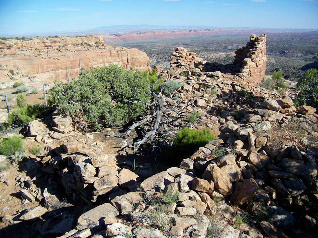


The location of the Dry Wash Overlook Ruins, along the rim at the head of a tributary to Comb Wash on the eastern edge of Cedar Mesa, makes it a significant site in the communication network across rugged terrain during the twelfth and thirteenth centuries. In addition to views of Comb Wash, from the ruins one can also see crossover trails along Comb Ridge (such as Jackson’s Crossing and Night Rider), Sleeping Ute Mountain to the east, the Carrizo Range to the southeast, and Black Mesa, the Chuska Mountains, and the San Juan River Canyon to the south. Monument Valley is also visible to the southwest, and it is likely that many contemporary Pueblo III sites would have also been visible from the towers at Dry Wash. The visual connection to so many features across the landscape—landforms, other towers, agricultural fields, and celestial alignments—is essential to understanding these ruins.
Dry Wash possesses four towers located directly above a permanent spring. They are integrated with other architectural elements including a series of pecked steps that provide easy access down to the spring and its curved enclosing wall. A structure that comprises five rooms and several granaries is tucked into a natural alcove below the canyon rim. The combination of habitation, storage, and towers was a common occurrence in the Northern San Juan region between 1100 and 1300—a period of tremendous upheaval, climate uncertainty, and movement.
The circular one-story towers lie on a boundary wall that stands between the rim of the canyon and the mesa. None of them seem to have ever possessed roofs. They lay 8, 5, and 9 meters apart from one another. The boundary wall arcs to the east of Tower 4 and ends at the rim. Tower 3 is best understood as a double tower with a semi-circular segment abutting it, probably at the same height. Their walls are wet-laid and two courses wide, constructed of unshaped sandstone blocks and slabs with chinking stones set into the mortar. The diameters of the towers vary considerably. While two of them are 7 meters wide, the second and fourth tower possess diameters of 5 meters and 3.5 meters, respectively. While the first three towers have somewhere between 50- to 60-centimeter-thick walls, the walls of the narrowest of them, Tower 4, are also the thickest at 90 centimeters. A diameter of 7 meters is unusually wide for this time and place and may be the result of the heavy-handed stabilization carried out in 1964. Unfortunately we do not possess any record of the site before or during the stabilization. Archaeologist Earl Smith created its first site map in 1968.
The site-enclosing wall at Dry Wash is one meter wide and 1.5 meters tall. It is roughly U-shaped. The enclosing wall associated with these towers is a unique element; it is likely that the towers, in relation to the wall and the spring, functioned in some defensive capacity, perhaps limiting or guarding access to the spring. The prominent location of the towers on the landscape was likewise an intentional way of increasing their visibility.
Although the Northern San Juan towers do not directly replicate Chacoan architectural forms, they seem to reference some of the same ideas that are found in Chacoan monumental buildings. Since the people of the Northern San Juan included descendants of Chacoans, this is not surprising. Ruth M. Van Dyke and Anthony G. King have suggested that McElmo-style masonry and site planning at Dry Wash Overlook Ruins reference Chacoan ideas. The siting of the towers suggests that builders were concerned with the visibility of iconic peaks. Two centuries earlier, Chacoans situated shrines, stone circles, great houses, and other structures to see high places in the San Juan Basin, such as Huerfano Mountain, Mount Taylor, and Hosta Butte. Sleeping Ute Mountain is not visible from Chaco Canyon, but it can be seen from Chacoan outliers along the western flanks of the Chuska Mountains, and these sites in turn are linked through lines-of-sight to Chaco Canyon. Towers in high places could have symbolized a visual link to the more stable social and ritual world of the Chacoan past.
References
Bradley, Richard. The Significance of Monuments: On the Shaping of Human Experience in Neolithic and Bronze Age Europe. New York: Routledge, 1998.
Bredthauer, Alison Vanessa. “A Towering Enigma: An Examination of Late Pueblo II and Pueblo III Towers in the Northern San Juan Region.” Master’s thesis, University of Colorado, 2010.
Churchill, Melissa, Kristin Kuckelman and Mark Varien. “Public Architecture in the Mesa Verde Region.” Paper presented at the 63rd Annual Meeting of the Society for American Archaeology, Seattle, Washington, 1998.
Van Dyke, Ruth M. “Chaco Reloaded: Discursive Social Memory on the Post-Chacoan Landscape” Journal of Social Archaeology 9, no. 2 (2009): 220-248.
Van Dyke, Ruth M., and Anthony G. King. “Connecting Worlds: Pueblo III Towers in the Northern San Juan.” Kiva 75, no. 3, (2010): 349-372.