

-
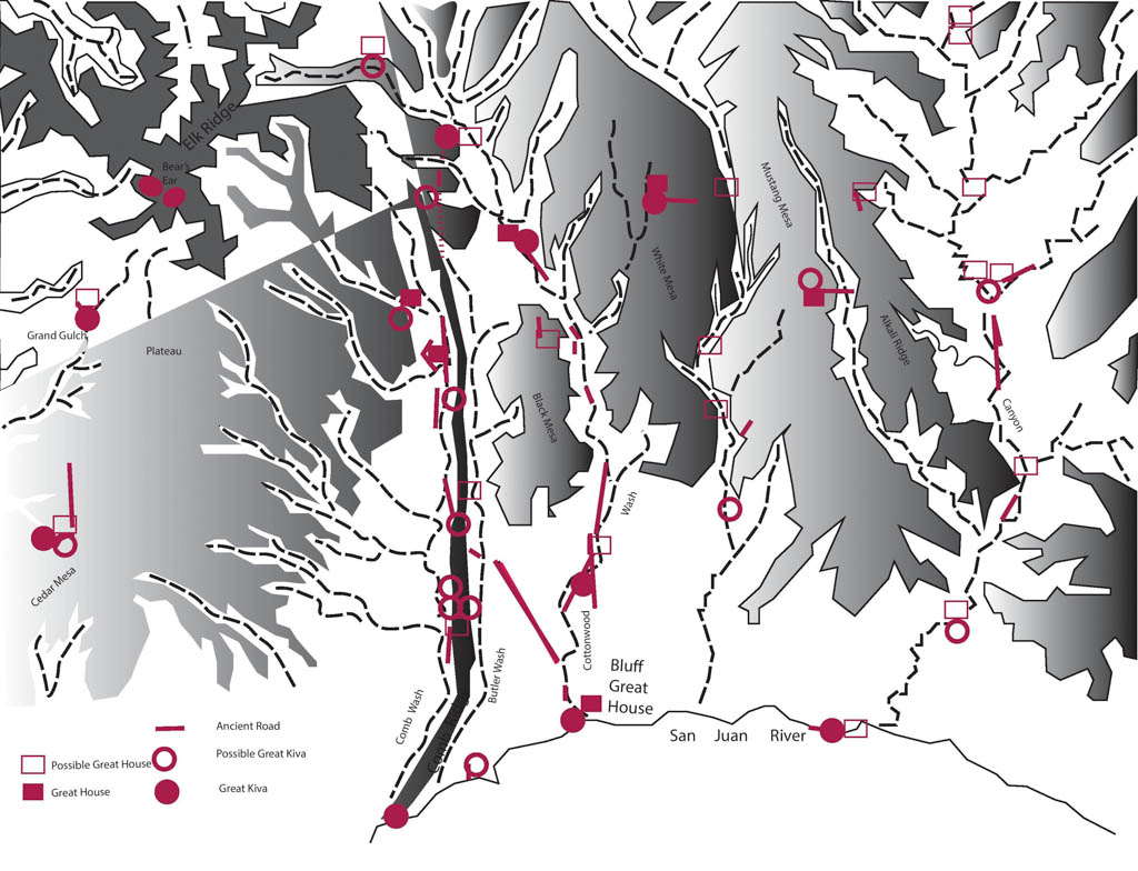
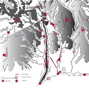 (Map by Shundana Yusaf)
The Four Corners area in Utah has several stretches of formally constructed Anasazi thoroughfares. These roads contribute to our understanding of the relationship between Chaco Canyon in present-day New Mexico, a major cultural center in the American Southwest between 900 and 1150, and areas far removed. Studies show that this region was far more integrated than once thought. The roads are fundamental to our growing understanding of Anasazi trade, economy, and social organization. They are the physical evidence of far-flung social and economic ties and they undoubtedly played a crucial role in the spread of a wide variety of beliefs, ideas, behaviors, art styles, and more.
These roads, in use between 900 and 1300, connect southeastern Utah and the adjacent states of Colorado, Arizona, and most significantly, New Mexico. Having neither pack animals nor the wheel to facilitate transportation, the Anasazi roads were essentially large and sometimes elaborately engineered trails that accommodated, facilitated, and controlled pedestrian traffic. They were built using a simple cut and fill technique; ground was prepared by clearing stones and earth. The roads followed the topography of the land. Climbing over cliffs, they were shaped into staircases made from large pecked steps with handholds. At other times, they were built to resemble ramps and grooves by builders who cut through the crest or edges of small ridges and packed the ground; low spots or washes were spanned with bridges.
Long Fingers Road, Tank Mesa Road, Cottonwood Road segments and others, all had U-shaped sections. The swales were rarely given formal surfacing. Their packing could be as thin as 30-50 centimeters, although thicker sections did exist. Like most roads in the Northern San Juan region, they were between 8 to 10 meters in width. Wider segments sometimes split into narrow “spur roads” although they generally ran relatively straight. Archaeologists Steve Lekson and Fred Nials believe that road alignments in the Chacoan system were maintained using naked-eye surveying.
A set number of architectural features accompany these roads, which often connected major Anasazi settlements. Archaeologist Winston Hurst notes that such settlements often had great houses, which served as communal centers. These houses were multi-functional entities, where the elite oversaw trade and religious rituals. Unlike the cliff dwellings or granaries, which were strategically located to blend with the surroundings, the great houses stood out as the most conspicuous elements of the landscape. Surrounding kivas, the great houses comprised multilevel rectangular rooms built in stone masonry and clay-based mortar. The Bluff Great House, the Edge of the Cedars Pueblo, and several other sites have great houses associated with the ancient roads that pass by them.
A second architectural feature associated with Anasazi roads are herraduras (Spanish for “horseshoe”). As the name suggests, these are horseshoe-shaped, low-walled masonry structures oriented to the east, with openings that range from 5 to 7 meters in diameter. Although their function is unknown, herraduras are thought to have been shrines or to have marked an intersection between two ancient roads. They are situated at topographical breaks along the road, making them visible from either direction. J-shaped “Windes’ shrines” are often found along these roads.
Some archaeologists believe that, instead of considering these roads as merely a physical link between Chaco and the Northern San Juan regions, the ancient roads also serve as a symbolic link, reinforcing community bonds as they connected the great houses of each village. Archaeologist Ruth van Dyke proposes that the roads be thought of as important connectors, prescribing formal routes of access for visitors and pilgrims to great houses. The roads may have been used for ceremonial races or ritual processions toward significant and/or spiritual sites at Chaco Canyon and outside of the canyon. Roads may have also been another way community leaders manipulated the landscape to encourage visitors to participate in a Chacoan ideology, using the roads to symbolize aspects of an Ancestral Pueblo worldview and to direct visitors toward specific spatial experiences.
Few of the Anasazi roads in Utah have been documented and none have been preserved.
References
Hurst, Winston B., Dale Davidson, and Owen Severance. “Anasazi Roads in Southeastern Utah.” Canyon Legacy 7 (October 1990): 12-15.
Van Dyke, Ruth M. The Chaco Experience: Landscape and Ideology at the Center Place. Santa Fe, NM: School for Advanced Research Press, 2007.