


The O’Grosky Towers are significant in understanding defensive strategies in the Northern San Juan region during the second half of the thirteenth century. The site is located on eastern flank of Comb Ridge, on the first low hogback uplift. Its ruins lie along the north rim of the mouth of a southeastern canyon that drains into Butler Wash. Based on the artifacts and architecture uncovered at the site, the complex dates to the Pueblo III period, when this region experienced tremendous social upheaval and environmental stress.
After the decline of Chacoan culture around 1150, there was a massive influx of people into the Northern San Juan region. This migration, in addition to climatic instabilities, likely contributed to episodes of violence and warfare, and safety was a huge concern. Late Pueblo III aggregated settlements and cliff dwellings would have optimized defense. By the latter half of the thirteenth century, two-thirds of the population were living in large pueblos, typically located at the heads of canyons, like those found in the O’Grosky complex.
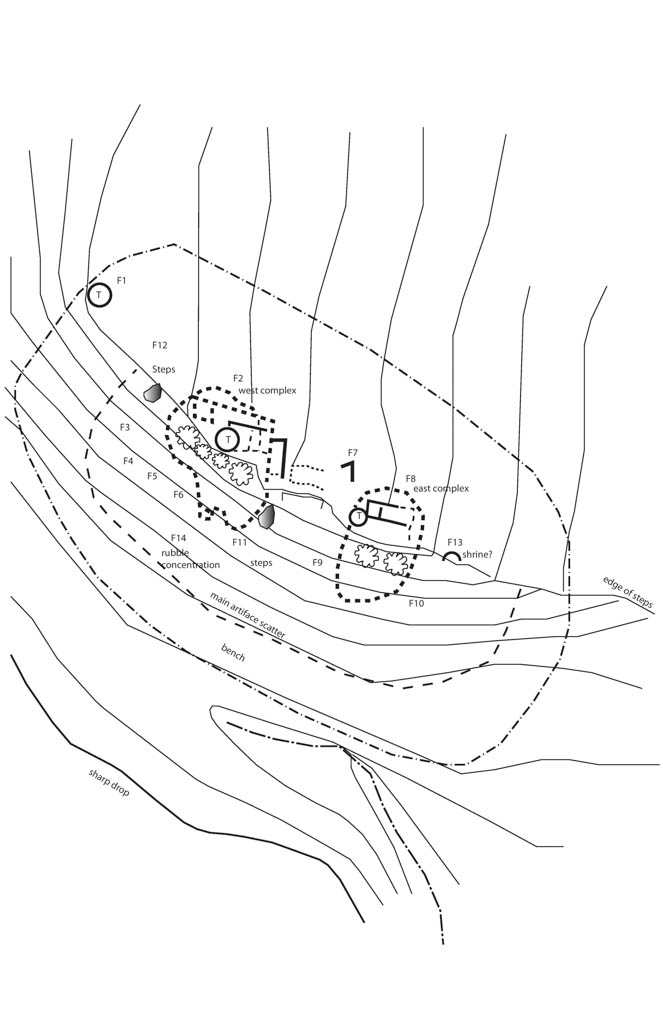
The complex comprises a block of thirteen rooms, three smaller room blocks, two to six kivas (the exact number is uncertain), an informal plaza area, and a low retaining wall along the northern site boundary. On a ledge below the canyon rim are two smaller room blocks reached by a series of pecked steps from the complex above. Within the settlement are three circular towers, one standing prominently in isolation and the other two attached to blocks of rooms. The towers would have been used by a social group larger than a single household and their construction clearly involved substantial investment of labor and cooperation. About 450 meters north of the site is a herradura (a horse-shoe shaped enclosure defined by a low wall) and a crossover trail to the White Triangle complex roughly a mile away. There do not appear to be any permanent water sources associated with the O’Grosky site, although the drainage below likely had water for at least part of the year.
The orientation of the site in the canyon implies that the complex was meant to be seen, especially from the south. The towers offer views to the north and south along Butler Wash and east to Tank Mesa. The Chuska and Abajo mountains serve as distant landmarks. The intervisiblity of the towers and landscape may have facilitated communication between communities and connotes political alliances between pueblos. Ethnographic research suggests that signaling might have been by smoke, fire, or mirror. Archaeologists have proposed the existence of a signaling system extending collectively over at least 375 miles. But intervisibility could also relate to the different layers of the Puebloan spiritual world; the critical concept may be that of an opening between worlds, or a conduit across space and time. Most contemporary archaeologists recognize that architecture and landscape constitute reflexive elements of the social world. These towers are closely associated with features that suggest openings to other layered worlds—kivas, water, boulder concavities, and earlier sites.
Tower 1, the only detached tower, is prominently located within the site, standing approximately 25 meters northwest of the complex. Since there are four courses of intact masonry on portions of the northeast and southwest walls, archaeologists have determined the towers were constructed with unshaped sandstone blocks and slabs, using a dry-laid laying technique only a single course wide, averaging only 40 centimeters in width. The tower was three meters in diameter and was likely unroofed, as no evidence suggests otherwise.
Unlike Tower 1, the other two towers were integrated into room block architecture. Tower 2, built using a similar construction as Tower 1, formed part of a surface room block consisting of 11 rooms. Its interior dimensions measure 3.5 x 2.8 meters. Tower 3 is integrated into the west end of a surface room block consisting of 4 rooms. Its interior dimensions measure 2.5 x 4 meters and the wall is a single course wide, with an average wall width of 40 centimeters. There is no evidence of an entrance for either tower.
All three towers at O’Grosky appear to have been close to two meters in height. Their prominent location within the complex and their noticeable presence in the landscape suggests that visibility was one of the most important considerations in their construction. While the location was significant, the construction—unprepared stone material and dry-laid masonry—suggests that the towers were not defensive and may have been used primarily for ceremonial use.
Although the site has not been excavated, it was mapped and documented in both 2002 and 2006 by the Comb Ridge Survey Project crew.
References
Bredthauer, Alison Vanessa. “A Towering Enigma: An Examination of Late Pueblo II and Pueblo III Towers in the Northern San Juan Region.” Master’s thesis, University of Colorado, 2010.
Bradley, Richard. The Significance of Monuments: On the Shaping of Human Experience in Neolithic and Bronze Age Europe. New York: Routledge, 1998.
Churchill, Melissa, Kristin Kuckelman, and Mark Varien. “Public Architecture in the Mesa Verde Region.” Paper presented at the 63rd Annual Meeting of the Society for American Archaeology, Seattle, Washington, 1998.
Robinson, Hugh. Draft IMACS site 155-2-008 form. Comb Ridge Heritage Initiative Project, Blanding, Utah, 2006.
Robinson, Hugh. Draft IMACS site CSM-2-007 form. Comb Ridge Heritage Initiative Project, Blanding, Utah, 2007.
Van Dyke, Ruth M., and Anthony G. King. “Connecting Worlds: Pueblo III Towers in the Northern San Juan.” Kiva 75, no. 3 (2010): 349-372.
Van Dyke, Ruth M. “Chaco Reloaded: Discursive Social Memory on the Post-Chacoan Landscape” Journal of Social Archaeology 9, no. 2 (2009): 220-248.