


On the northern shore of Lake Union formerly known as Brown’s Point, Gas Works Park stands as a re-imagining of a former gasification plant into an iconic park for the city of Seattle. This unique project is perhaps one of the first examples of the conversion of a post-industrial landscape into a public park.
The site, a twenty-acre promontory, was developed into a gasification plant in 1906 by the Seattle Gas Light Company. In the early part of the century, the gas produced on site was manufactured by the carbonization of coal and was used to illuminate residences and businesses. Over the years this use was expanded to stoves and heating. As the population of Seattle grew, the gas plant expanded to meet the increasing demand. The gas company dominated the fuel industry into the 1930s, when hydroelectric power was introduced to the market. At the same time, citizens were increasingly complaining about the negative impacts to the environment and their health as a result of the gas plant operations, and in 1934 the City passed an ordinance requiring the company to clean up the plant. The gas works was converted from coal to oil in 1937 and used up to 50,000 barrels of oil a day. Pollution continued to be a source of public complaints into the 1950s. In 1954 the Seattle Gas Company was granted permission by the Federal Power Commission to create a pipeline from Canada, and in 1956 natural gas was introduced. On December 21, 1956, the gas plant was officially closed and the plant remained idle for the next two decades.
In the early 1960s, city councilperson Myrtle Edwards proposed the idea of converting the site into a park. Working with the mayor, Edwards negotiated the purchase of the gas works property in installments over a ten-year period in which the gas company was required to demolish all equipment and clear the site by the time of final payment. When voters approved a Forward Thrust bond in 1968, it guaranteed the construction of a park by allocating $1,750,000 for the development of the plant site. The following year the City Council decided to name the future park in honor of Myrtle Edwards, who had recently died in a car accident.
In 1970, after receiving several proposals for the design of the park, the City Council was split between two landscape architecture firms: Richard Haag and Associates of Seattle and Dan Kiley of Vermont. Unable to break the tie, the Council decided to give Kiley another larger project, Discovery Park, and Richard Haag was given the gas works site.
As Haag began to study the site, he realized the old industrial structures could be incorporated into the design of the park. When the master plan was submitted, it met a great deal of public resistance. The gas plant was seen as an eye sore and a reminder of its polluting past and, furthermore, did not fit within the public perception of what a park should be. Haag began a campaign to build support for the master plan by finding an ally in the gas company and by speaking to interested public and private groups. Nevertheless, there was still a great deal of resistance from the community, including the family of Myrtle Edwards, who disapproved of the park plan and fought for an arboretum-style park, later declining to have the park named after her. The controversy came to a head when a public hearing at the Ames Theater had approximately 1,200 attendees who had shown up to voice their opinions. The strong public support following the meeting made the decision to move forward with the park design more politically palatable, and the City Council unanimously approved the park plans within the following weeks.
The park was built in phases, beginning with clearing the site of hazardous structures and adding roofs to the old boiler house and the exhaust building to provide a picnic shelter and playbarn of brightly painted machinery, respectively. Contaminated soil was shifted to create the foundation of the “Great Mound” that became a natural amphitheater and high point from which to view the city. The second phase was completed in the summer of 1976 and included additional picnic areas, a parking area, and a lakeside platform. In 1977, local artists Chuck Greening and Kim Lazare unveiled a sun and moon dial, which incorporated pieces of aluminum salvaged from a crashed police helicopter.
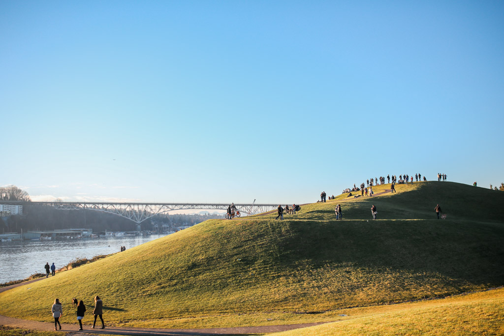
Following a long tradition of land forming as a part of city-making, Haag reshaped the promontory of north Lake Union. He created dynamic hills where there was a gradual slope, valleys where they had been flat marshland. While others flattened the landscape, Haag honored and celebrated the varied topography of the region—a vertically rich landscape. The relationship between land and water at Gas Works Park is reminiscent of Seattle’s landscape, with the soft edges of vegetation and eroding soil and depositional rock suggesting the marshes and wetlands that once comprised the city’s waterfronts from Pike Place Market to Lake Washington. The topography of Gas Works Park thus serves as a microcosm of the city with its view points and its protected inlets as well as a reminder of its own history.
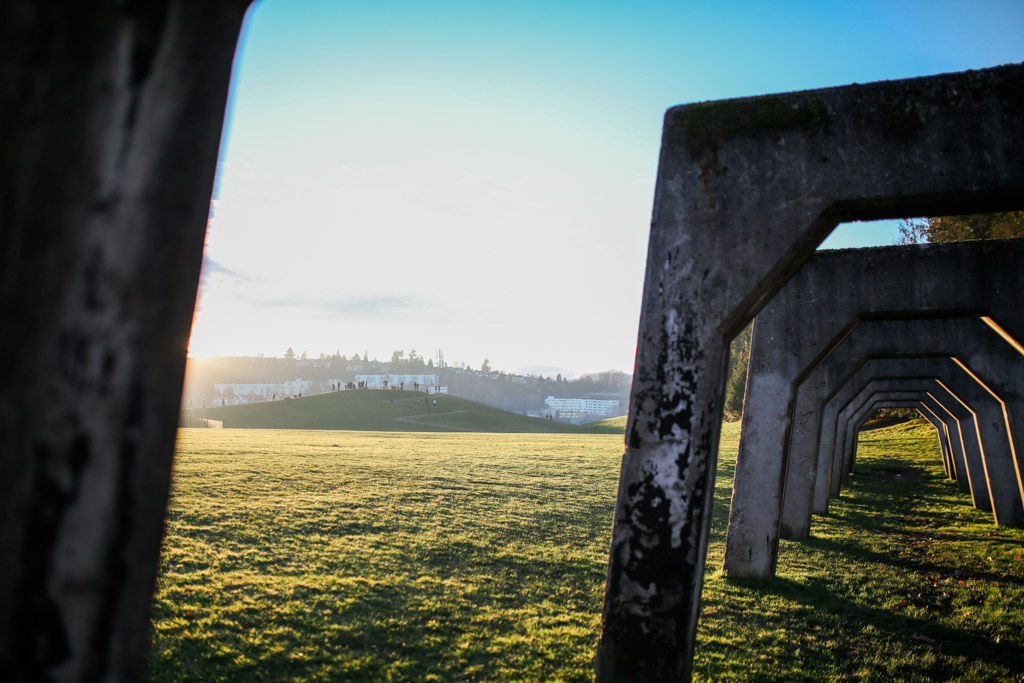
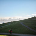
One experiences Haag’s microcosm of Seattle upon entering the site from the north. After crossing through the parking lot and over the forested threshold, one arrives into a small valley framed by the Great Mound to one side, also known as Kite Hill, and the Towers to the other. An iconic view of Seattle’s Capitol Hill neighborhood lies ahead. It is here that the narrative of the landscape is first revealed to the careful reader: the forest is behind, the water ahead, with a landscape of hills and mountains framing a vista of the city.
Kite Hill is climbed by means of a spiraling path that culminates at the top with a sundial that uses the observing person as its gnomon. Looking out over the scene, the gas works towers lead the eye across the water to the urban setting of city, then around the bowl to the Space Needle, across to the Queen Anne neighborhood, and back to the fishing industry of Ballard. These are the histories of Seattle: the settling of a city in the hilly landscape, the struggle to flatten the city site, the aspirations of the mid- to late twentieth century, and the industries of gas and fish, as well as logging and high technology.
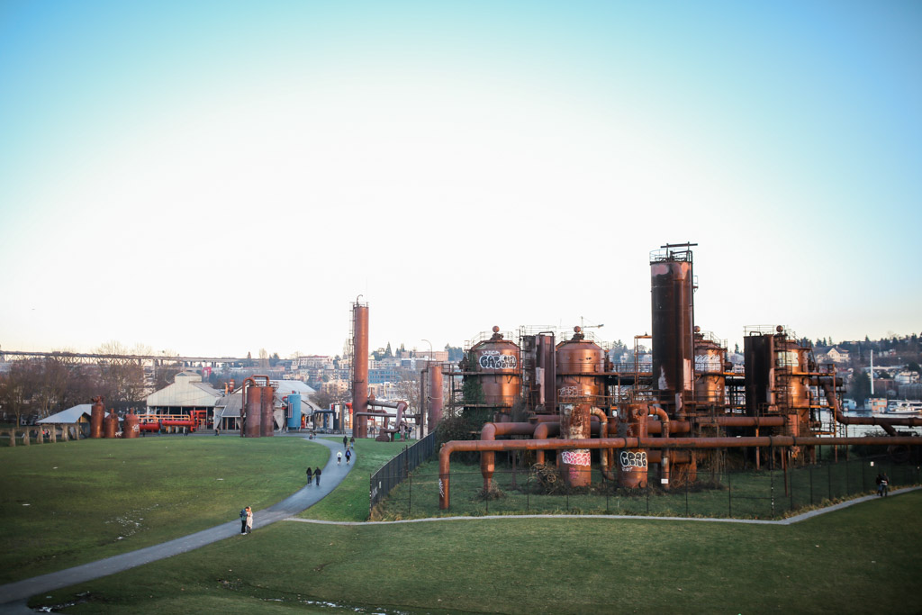
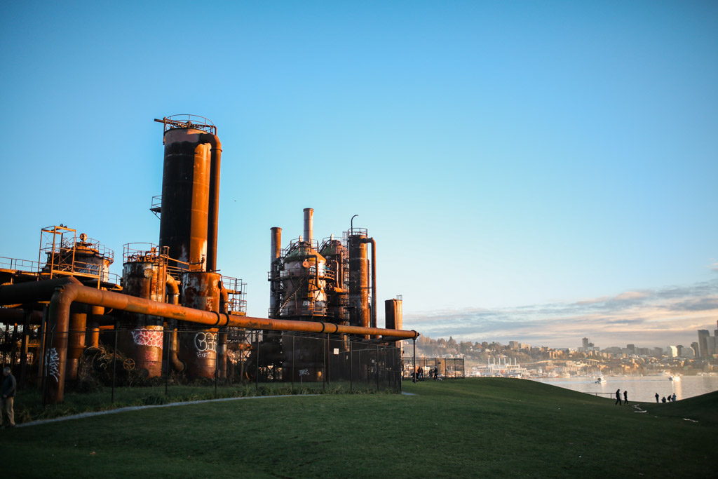
Down Kite Hill is the waterfront, where the land drops precipitously to meet Lake Union. Near the water’s edge, a promontory holds a large concrete form now serving as a terrace at the water’s edge. Once the loading dock for the coal plant, this point reaches farthest into the water. By means of the sea wall, the land pushes the waterline outward as it did in the pre-industrial days. Thus, the curved line of coast is a remnant of both a longer history as the northern shore of the lake and the more recent industrial uses now overlaid with contemporary programs and events, including Fourth of July fireworks.
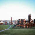
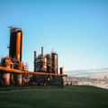
The view of the park from afar is of a meandering coastline along the northern edge of Lake Union, bordering what can be read as green lawn that serves as setting for immense rusting towers of industry. This is juxtaposed against the Great Mound set against a background of coniferous trees. The view engages Seattle’s icons—the water and coastline, the trees and forests, the hills and mountains. The towers remind us of the industrial past, its scale, its presence, and its traces. The Great Mound, covered in what first appears as an innocuous green lawn, contains the toxic soils generated by the industry that, in turn, is symbolized by the towers and other architectural remains.
Serving as an example of reclamation and bioremediation of a post-industrial landscape, today Gas Works Park is a place of celebration for the city of Seattle, hosting events throughout the year, as well as being a place where visitors can enjoy the view of Seattle’s skyline from several vantage points and watch the passing boats and seaplanes landing in the lake. In 2013 Gas Works Park was listed in the National Register of Historic Places.
Gas Works Park remains a model for experimentation in public landscapes. It continues to be monitored and a variety of remediating approaches have been considered and tried.
References
Richard, Michael. Seattle’s Gas Works Park: The History, the Designer, the Plant, the Park, Map & Tour. Seattle: M. Richard, 1983.
Way, Thaïsa. “Under the Sky: Landscapes of industrial excess: A thick sections approach to Gas Works Park.” Journal of Landscape Architecture (JOLA) 11, no. 1 (Spring 2013): 28-39.
Way, Thaïsa. The Landscape Architecture of Richard Haag: From Modern Space to Urban Ecological Design. Seattle: University of Washington Press, 2015.